
1. What is PW? PW stands for Precipitable Water. It is a parameter which gives the amount of moisture in the troposphere. 2. How is PW determined? PW is determined by taking all the mass of water vapor in the troposphere and depositing it on the earth's surface. The depth of moisture that would be on the earth's surface is the PW value. The mass of water vapor is determined by the dewpoint (saturation mixing ratio) of the air integrated over the troposphere. Higher dewpoints lead to higher PW values, especially if the relatively high dewpoints extend through a significant vertical depth. The scale below gives an indication of the moisture content of the troposphere via PW. 0.50 inches or less = very low moisture content 0.50 to 1.25 inches = low moisture content 1.25 to 1.75 inches = moderate moisture content 1.75 to 2.00 inches = high moisture content 2.00 inches or above = very high moisture content At the bottom is a sounding from Grand Junction, CO. This is an inverted-V sounding with a low PW. The PW, as can be seen from the parameters given to the right of the sounding, is 0.64 inches. 3. Operational significance of PW: Severe Storms: Tropospheric moisture determines whether a supercell storm will be HP (High Precipitation), Classic, or LP (Low Precipitation). HP supercells often have PW of 1.75 inches or above and LP supercells often have a PW value of less than 1 inch. For more information on these supercell types, go to link below: http://theweatherprediction.com/habyhints/42/index.html Flooding potential: A forecast area has a climatological normal PW for a certain time of year. In cases where the PW value is 2 to 3 or greater times more than the climatological value, flooding becomes more likely when a heavy precipitation event occurs. This often occurs in drier climates whose vegetation and land is not adapted to absorbing large amounts of precipitation. Lightning: In a high CAPE environment, high PW will lead to storms that produce an abundant amount of lightning. Updraft velocity: PW is the most significant contribution to water loading. Water loading reduces updraft strength since gravity tries to push the precipitation mass downwards-- against the momentum of the updraft. High PW also produces a heavier downdraft. The updraft being reduced is especially evident in a weak shear environment where the downdraft locates very near the updraft, thus destroying the updraft. Hail: High PW tends to reduce hail size since the updraft velocity is reduced. Classic supercells are often better large hail producers compared to HP supercells (HP supercells often form in very moist low elevation environment). Convective wind gusts: A high PW often occurs when the troposphere is fairly saturated. This can reduce convective wind gusts since convective wind gusts require dry mid-level air to add to their significance. Winter weather: It is more important for the troposphere to be near saturation than it is for the PW to be high in a winter weather situation since lifting, rather than instability release, is most important in precipitation generation. Cold temperatures limit the amount of PW. Winter soundings can have a low PW and still produce significant precipitation events if lifting and saturated conditions exist. 4. Pitfalls: PW should not be used directly to forecast precipitation amounts (i.e. 1.25 inches of PW does not mean 1.25 inches of precipitation will occur). Factors such as storm motion, moisture convergence, areal coverage of precipitation, amount of lifting and instability release, etc. also determine precipitation amount other than the amount of moisture in the air. 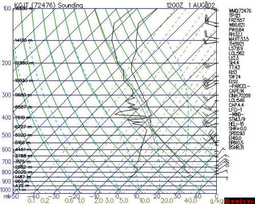 |