
1. What is CAPE? CAPE (Convective Available Potential Energy) is the integration of the positive area on a Skew-T sounding. The positive area is that region where the theoretical parcel temperature is warmer than the actual temperature at each pressure level in the troposphere. The theoretical parcel temperature is the lapse rate(s) a parcel would take if raised from the lower PBL. 2. How is CAPE determined? The positive area on a sounding is proportional to the amount of CAPE. The higher the positive area, the higher the CAPE. The positive area is that area where the parcel sounding is to the right (warmer) than the environmental sounding. The units of CAPE are Joules per kilogram (energy per unit mass). The sounding at the bottom of this page shows a CAPE value of 2,032 Joules per kilogram. 3. Operational significance of CAPE:
High CAPE means storms will build vertically very quickly. The updraft speed depends on the CAPE environment. Hail: As CAPE increases (especially above 2,500 J/kg) the hail potential increases. Large hail requires very large CAPE values. Downdraft: An intense updraft often produces an intense downdraft since an intense updraft will condense out a large amount of moisture. Expect isolated regions of very heavy rain when storms form in a large or extreme CAPE environment. Lightning: Large and extreme CAPE will produce storms with abundant lightning. 4. Pitfalls: a. Storms will only form and the CAPE actualized if the low level capping inversion is broken. b. CAPE magnitude can rise or fall very rapidly across time and space. 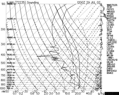 |