
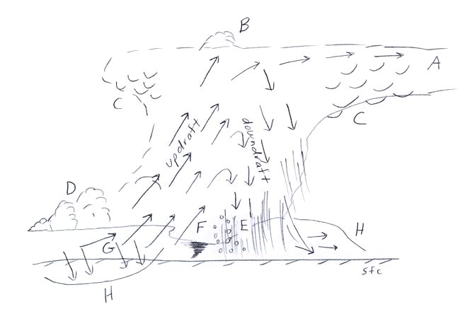
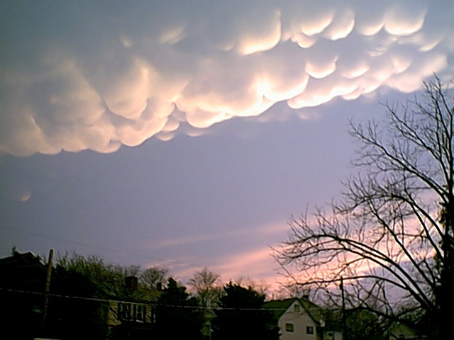
 The diagram above shows the primary characteristics of a supercell thunderstorm. Each of the terms in the supercell storm are defined below: A. Anvil- The Anvil is one of the most impressive features of a severe storm due to its areal coverage and icy texture. Within a severe storm, moisture is transported from the lower troposphere to deep into the upper troposphere. Not all moisture that is ingested into a storm is precipitated out of the storm. Some of the moisture in a strong updraft is lofted so high into the troposphere that it is not able to drop back down immediately. Strong upper level winds move and fan the moisture out over great distances. The temperature of the anvil is frigid cold. The light density of the moisture allows the wind to move it at will. A forecaster can note the direction and speed of the upper level winds by noting the anvil's orientation. The moisture within the anvil will be blown downstream. B. Overshooting Top- The core of the updraft has the strongest convective upward vertical velocity. This core of rapidly rising air will only slow down and stop when it encounters a very stable layer in the atmosphere. This very stable layer is the tropopause. Air will rise as long as it is less dense and therefore more buoyant than surrounding air. The faster air rises the longer it takes generally to slow down and stop once it encounters a very stable layer. This occurs because a moving object has momentum. That part of the updraft that has the greatest momentum will form the overshooting top on a severe thunderstorm. C. Mammatus- Mammatus are pouched shaped clouds that protrude downward from the thunderstorm's anvil. They form as negatively buoyant moisture laden air sinks. The cloud remains visible until the air sinks enough that the relative humidity falls below 100%. The portion that has a relative humidity of 100% remains visible. Theories to how they form include: 1) turbulent eddies mixing down moisture, 2) evaporative cooling with surrounding air causes pockets of sinking air, 3) Pockets of precipitation falling out of the anvil that produce virga. Mammatus tend to be most prominent in extremely severe storms but can occur when storms are not severe also. Click here for an image of mammatus clouds. D. Flanking Line- The flanking line is produced by convergence along an outflow boundary extending from the storm. This outflow is often air from aloft that is converged into warm and moist air near the surface. It can be seen as a line of developing cumulus clouds extending from the storm. The cumulus closer to the storm tend to be more mature and eventually merge into the parent storm. The flanking line often feeds into the updraft of the storm. E. Rain Core / Hail Core- The core refers to the heaviest precipitation. The most violent rain and hail in a supercell tend to be on the outer edge of the updraft on the downdraft side of the storm. Extreme turbulence on the edge of the updraft can contribute to significant hail growth. As hail falls into above freezing air it sheds its moisture as rain. F. Wall Cloud- The wall cloud is located in the updraft region of a supercell. Rising air cools and condenses out moisture once it is saturated. Due to the rapidly rising air and the verticality of the rising air, the cloud base is close to the ground within the wall cloud. The wall cloud will often be witnessed as rotating since directional wind shear acts on the updraft as it rises. Tornadoes can occur under the wall cloud. G. Rain-Free Base- The updraft region in supercells will often lack precipitation. This is most true for developing supercells and for classic/LP supercells. As a supercell matures or has a high moisture content, often precipitation will wrap around the updraft region and eventually fall into the updraft region. The updraft region of a supercell will be tilted with height. This will deposit the precipitation away from the updraft and thus this also results in less precipitation in the updraft region. Being in the rain free base region offers an awe-striking view of the storm. H. Forward Flank / Rear Flank Downdraft- The forward flank downdraft is the outflow from the rain-cooled air of the storm's downdraft. The rear flank downdraft is air from aloft that is transported down to the surface from colliding with the storm. The rear flank downdraft air tends to be dry and warm since the air warms by adiabatic compression as it sinks to the surface. Adiabatically warmed air will also decrease in relative humidity if no precipitation falls into the air. The rear flank downdraft tends to be warmer than the forward flank downdraft also since rain the evaporational cooling is not as common in the rear flank. Shear is enhanced along these flanking downdraft boundaries and the shear can be magnified along where the two flanks merge. The right balance of shear and instability release can lead to tornadogenesis. |