
Much of the light precipitation detected on radar does not reach the ground. This is especially true if there is a dry layer of air between the surface and from where the precipitation is falling. This is even more especially true if the precipitation falls through a deep dry layer and the precipitation begins the fall from high aloft. Rain falling from high aloft is very common in the downwind portion of a thunderstorm. Mammatus and virga are common on the downwind side of a storm. When the radar beam gets high enough it will detect these thick clouds and virga aloft. This may mislead the radar operator into thinking precipitation is reaching the ground in those locations when it is not. Strong winds will shear the top of a thunderstorm. This moves thick cloud, precipitation and virga downwind from the storm. If this shows on radar as a green color it is likely not reaching the ground. Keep the following in mind: 1. Anvil blowoff will be especially evident at long ranges from the radar since the radar beam increases in elevation away from the radar site. 2. Anvil blowoff will generally show as light reflectivity (usually color coded green) and this reflectivity generally does not result in precipitation reaching the ground. 3. Strong updrafts in a strong shear environment (strong upper level wind) will often have the anvil blowoff showing on radar. 4. Anvil blowoff tends to show up best on composite reflectivity since it is using multiple tilt angles and showing reflectivity from all the different angles. Here are some example of anvil blowoff from storm(s) on radar: 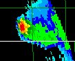 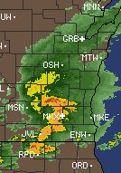 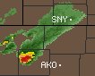 |