
1. What is HEL? Helicity (HEL) is a mathematical quantity derived from: 1. speed shear (how much wind speed increases with height) between the surface and 3 km above, 2. directional shear (how much wind speed changes direction with height) between the surface and 3 km above, 3. The strength of the low level wind directly into the speed and directional wind shear. The stronger each of these components is the higher the helicity. The sounding at the bottom has a helicity of 28. It is low since the wind direction does not change much between the surface and 3 km above and the wind speed is not increasing with height between the surface and 3 km above. The low level wind speeds are not impressive either. Storms that develop in this environment will likely not be supercellular and will not rotate. 2. Operational significance of HEL:
TORNADOES: Tornado risk becomes more likely with high helicity values when severe storms develop especially if adequate CAPE and moist low level air are in place. 3. Pitfalls: a. HEL gives no assessment of cap, CAPE and low level moisture. Check these on forecast soundings. b. Mesoscale influences can rapidly enhance the helicity value. 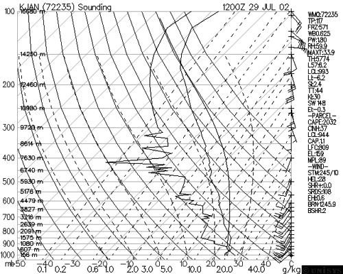 |