
The vorticity advection term is also called the upper level divergence term. The upper levels generally extend from 550 millibars to the tropopause. Upper level divergence occurs when a mass of air is pulled away from a region faster than that mass can be replaced. This most commonly occurs when the upper level wind field is strong and meridional (high amplitude upper level waves). An operational forecaster locates regions of upper level divergence by locating the divergence sector of a vorticity gradient near the LND (Level of Non-divergence). The LND is closest to the mandatory level of 500 mb, thus upper level vorticity is usually plotted on this prog. The LND is the general level that separates the low levels of the troposphere from the upper levels. Vorticity advection is best assessed near the LND. A process that creates upper level divergence is DPVA (Differential Positive Vorticity Advection). DPVA has been previously defined in the Haby Hint given below: http://www.theweatherprediction.com/habyhints/65/ Since the wind speed is generally higher in the upper levels of the troposphere as compared to the low levels of the troposphere within regions of PVA, a forecaster can usually take for granted that the PVA is differential (increasing with height). Thus the D in DPVA is often left off. An operational forecaster recognizes PVA by locating: a. The downstream region of relatively higher vorticity values along with the gradient of vorticity values, b. the wind speed of air through the gradient of vorticity, and c. the angle the airflow goes through the vorticity gradient PVA generally occurs in the downstream region (region where airflow is moving away from highest values of vorticity) of a vort max or vort lobe. The following Haby Hint defines a vort max and vort lobe: http://www.theweatherprediction.com/habyhints/217/ PVA is maximized by the combination of: a. high values of vorticity, with more importantly a large rate of change (gradient) of vorticity, b. a strong, downwind of vort max, airflow through the high gradient of vorticity, c. an airflow perpendicular to the vorticity gradient Below is an example that should help clarify this process an operational forecaster goes through in locating PVA. The prog below shows 500-millibar vorticity. 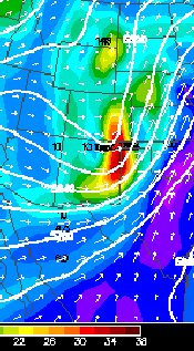 The vort max and the region of highest vorticity values are located in the red shading mostly on the New Mexico/Texas Panhandle border. The gradient in vorticity across the vort max is fairly sharp. The value of vorticity changes over 10 units over a distance of 100 miles. The following Haby Hint explains how the units of vorticity are calculated: http://www.theweatherprediction.com/habyhints/194/ That region of the vort max/vort lobe that experiences uplift is the downstream portion. An operational forecaster will draw a line through the vort max and perpendicular to the airflow. It is the region to the east of this line, in this particular example, that is experiencing PVA (Texas Panhandle and extreme southeast Colorado). Since this shortwave is moving toward the east, the entire Texas panhandle and western Kansas will experience PVA over the next several hours. The airflow through the vort max is strong and close to perpendicular, especially on the southern side of the region of high vorticity where the horizontal wind vectors are longer. This helps maximize the amount of vorticity advection at this location. DPVA leads to rising air on the synoptic scale. Thus, a forecaster locates these regions of enhanced uplift in order to determine areas that are most likely to receive precipitation. Precipitation as a result of DPVA alone is often termed dynamic precipitation. This precipitation tends to be high based also since the lifting is most intense in the upper troposphere (assuming DPVA is primary lifting mechanism). Severe weather is enhanced where strong DPVA overrides low level moisture, instability and low level WAA. A process that creates upper level convergence and thus sinking air is DNVA (Differential Negative Vorticity Advection). NVA generally occurs in the upstream region of a vort max or vort lobe. Usually when strong PVA is found a region of strong NVA will be coupled upstream from the PVA. The same mechanisms that maximize PVA also maximize NVA. The only difference is that NVA occurs in the region the airflow is approaching higher values of vorticity (upstream region) and PVA occurs in the region the airflow is moving away from the higher values of vorticity (downstream region). From the example examined previously, NVA is occurring in central/eastern New Mexico and central Colorado. NVA enhances sinking air, thus precipitation and severe weather is less common in the NVA region of a vort max. |