
One term in the omega equation is thermal advection. This essay will be interested in the operational meteorology interpretation of thermal advection and the contribution it gives to vertical motion. For this essay I will use the UNISYS graphical output and explain how to interpret it when it comes to thermal advection: http://weather.unisys.com/nam/850.php Thermal advection can be divided into Warm Air Advection (WAA) and Cold Air Advection (CAA). We can also divide the troposphere in the Low Levels (LL) which is between the surface and 550 millibars and the Upper Levels (UL) which is between 550 millibars and the tropopause (~150 millibars). This gives us 4 operational interpretations of thermal advection. Each of these is discussed below along with the operational significance. 1. Low Level Warm Air Advection (LL WAA)- Warm air advection is the movement of warmer air toward a fixed point on a horizontal plane. Adiabatic warming due to the air sinking and also air warming at a fixed point due to solar radiation are not WAA. Remember that thermal advection is always about a horizontal plane. LL WAA is common behind warm fronts and ahead of cold fronts. LL WAA contributes to rising air. Do not confuse the adiabatic cooling from rising air with WAA. The layer in which WAA occurs will generally warm more from WAA than will cool by the rising air process although the rising motion exacerbated by other lifting mechanisms, radiational cooling and evaporational cooling can partially and sometimes completely offset the warming from WAA. LL WAA contributes to rising air because warm air is less dense than cold air. Since warmer air expands to a larger volume than cold air, this expansion in the low levels pushes the air above the low levels up also. Keep in mind that this upward motion is slow and on the synoptic scale. The rate that the air rises is much less than the rate the air rises in an updraft of a thunderstorm. Synoptic upward vertical motion varies generally between 1 and 30 centimeters per second. An example of LL WAA is shown in the state of Indiana below: 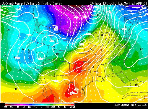 2. Low Level Cold Air Advection (LL CAA)- Cold air advection is the movement of colder air toward a fixed point on a horizontal plane. Adiabatic cooling due to air rising, evaporative cooling and also air cooling at a fixed point due to radiational cooling are not CAA. LL CAA is common behind cold fronts. LL CAA contributes to sinking air. Do not confuse the adiabatic warming from sinking air with CAA. The layer in which CAA occurs will generally cool more from CAA than will warm by the sinking air process although the sinking motion exacerbated by other sinking mechanisms, condensational warming and the warming of air by solar heating can partially and sometimes completely offset the cooling from CAA. LL CAA contributes to sinking air because cold air is denser than warm air. Since cooler air is more contracted than warmer air, this contraction in the low levels forces a sinking motion aloft to compensate for the reduction of volume in the LL. Thus, in the ideal case the skies will clear behind cold fronts. An example of LL CAA is shown in the states of Nebraska and South Dakota below: 3. Upper Level Warm Air Advection (UL WAA) and Upper Level Cold Air Advection (UL CAA)- Thermal advection is generally much less significant in the upper levels as compared to the low levels. The upper levels are much more uniform in temperature and the flow is more zonal and geostrophic thus thermal advection is usually weak. For LL WAA to produce a rising motion, the WAA must decrease with height. Similarly, for LL CAA to produce a sinking motion, the CAA must decrease with height. This generally always occurs since UL thermal advection is weaker than LL thermal advection. From an operational meteorology standpoint, UL thermal advection can be ignored in most cases. IMPORTANT POINTS: a. In complex situations differential advection occurs (WAA and CAA both occurring in the LL (i.e. surface to 700 mb WAA and 700 mb to 500 mb CAA or vice versa)). In these cases the magnitude of each thermal advection needs to be analyzed. b. There is not a direct relationship between thermal advection and resultant vertical motion in the atmosphere since other lifting and sinking mechanisms can complicate the picture (i.e. upslope flow, LL CAA, and divergence aloft occurring at same time). In these cases the magnitude of each lifting or sinking mechanism needs to be analyzed (often done by model output of resultant UVV over forecast region). c. Evaporative cooling, condensation warming, solar heating, complex topography, and radiational cooling contaminate thermal advection. A forecaster will examine these contaminating factors to determine the actual magnitude of the resultant thermal advection. For example, the warming and uplift from LL WAA will be reduced in cases where precipitation is falling into the low levels and cooling the air through evaporation. |