
Washington State is a truly unique place to live and forecast. The states weather is greatly affected by topography, Oceans, and different air mass types. Because of these distinctive attributes, and characteristics the weather can vary greatly in precipitation quantity, and overall weather pattern. Trying to determine when and where there is going to be rain, snow, fog, wind, cold, warmth, clouds, sunshine and even the occasional thunderstorm can make forecasting in the Washington state extremely demanding. Western Washington is influenced by Maritime Polar air that comes in off the pacific. With that two mountain ranges (the Olympics near the coast) which influence weather so greatly that they create a series of smaller climates through out the western part of the state. Further to the east the Cascades Mountains stand as a magnificent North to South obstruction to Pacific storms, and Maritime Polar air masses. It literally acts as a blockade to mid-latitude cyclones that come in off the Pacific, but also stands to confine the Maritime air to the west and dryer continental air masses to the east. The location of the State of Washington on the windward coast in mid-latitudes is such that the climatic elements combine to produce a predominantly marine-type climate west of the Cascade Mountains, while east of the Cascades, the climate possesses both continental and marine characteristics. Considering its northerly latitude, 46 to 49, Washington’s climate is mild. There are several climatic controls which have a definite influence on the climate, of both western Washington, and Eastern Washington, namely; (a) Pacific Ocean, (b) Cascade Mountains, (c) Different air masses. The effect of these various controls combines to produce entirely different conditions within short distances, or microclimates. There are two ranges of mountains parallel to the coast to the prevailing direction of moist air moving inland from over the Pacific. The first orographic lifting and major release of moisture occurs along the western and south west slopes of the Olympic Mountains. The second area of heavy orographic precipitation is along the windward (western) slopes of the Cascade Range. Theses mountain ranges are approximately 4,000 to 10,000 feet in elevation, and act as topographic and climatic barrier separating the State into eastern and western Washington. To the east of the cascades dryer weather is generally the rule. Most of the storm systems that move in off the Pacific drop most of there precipitation on the west side of the Cascades, leaving the rain shadow to the east. East of the Cascades, summers are warmer, winters are colder and precipitation is less than in western Washington. Warming and drying of air as it descends along the lee (eastern) slopes of the Cascade Range results in near desert conditions in the lowest section of the Columbia Basin. Most of the air masses and weather systems crossing eastern Washington are traveling under the influence of the prevailing westerly winds. Infrequently, dry cold continental air masses enter the inland basin from the north or east. In the summer season this air from over the Southwest United states which results in low relative humidity and high temperatures, while in winter clear, cold weather prevails. Extremes in both summer and winter temperatures generally occur when the inland basin is under the influence of air from over the continent. East of the Cascades, summers are warmer, winters are colder. Also there is less precipitation than in western Washington. During the coldest months, a loss of heat by radiational cooling at night and moist air crossing the Cascades mixes in the inland basin results in cloudiness, and occasional freezing drizzle. Sometimes a “Chinook” wind which produces a rapid rise in temperature occurs a few times each winter. These two distinctly different halves of the state, are unique in there own climates, and weather patterns. Certainly the largest contributing factor is the Cascade Mountains. The Puget Sound Lowlands area includes a narrow strip of land along the west side of Puget Sound southward from the Strait of Juan de Fuca to the vicinity of Centralia to the southwest and a somewhat wider strip along the east side of the Sound extending northward to the Canadian Border. Variations in the temperature, fog, rainfall and snowfall are due to such factors as distance away from the Sound. Occasionally in the winter season, cold air from the interior of Canada flows southward through the Fraser River canyon and over the northern Puget Sound lowlands. This cold air intrusion can often be the cause of heavy snow accumulations in the winter time, as warm wet systems move in off the Pacific, and override the cold air that is in place from the Fraser River Valley. In the winter season prevailing wind directions is from the south or southwest, and from the northwest direction in summertime. Annual precipitation of 37 inches from the Canadian Border to Seattle, and even more to the south of Seattle because of the prevailing storm track from the south/ southwest. The winter season snowfall generally ranges from 10 to 20 inches. This statistic may be very misleading since many areas in the Puget Sound that are away from the water, and have greater elevation, so in the foothills of the Cascades is where you have greater elevation so they receive more snow. Compared to many places in the lower elevations near the water, which rarely see snow. Both rainfall and snowfall increase with a slight increase in elevation and distance from the Sound, and increase topography. Snow generally melts rather quickly if it does occur near sea level due to the influence of the warmer Maritime Pacific influence. Eastern Washington is part of the large inland basin east of the Cascades. In a north south direction, the Cascade Range forms a barrier and confines to the easterly movement of moist and comparatively mild air in winter and cooler moist air in summer. To the east the Cascades block hot continental tropical air from moving west, in the summer, and cold dry continental polar air from moving west in the winter. Some of the air from each of these source regions reaches this section of the State and produces a climate which has some of the characteristics of both continental and marine type climates but that scenario is fairly rare!! Most of the air masses and weather systems crossing eastern Washington are traveling under the influence of the prevailing westerly winds, and must cross the Cascades Mountains which removes quiet a bit of moisture from mid latitude cyclones. Infrequently, dry continental polar air masses enter the inland basin from the north or east in the winter. In the summer season air from the southern deserts (continental tropical air) moves north and results in low relative humidity and high temperatures, while in winter clear, cold weather prevails. Extremes in both summer and winter temperatures generally occur when the inland basin is under the influence of air from over the continent. East of the Cascades, summers are warmer, winters are colder and precipitation is less than in western Washington. Washington's climate varies greatly from west to east. A fairly moderate, humid climate predominates in the western part of the state, while hot & cold dry climate prevails east of the Cascade Range. Looking at the climatology and statistics of both Western and Eastern Washington you can see that the western part of Washington state has much less variability on an annual basis in terms of temperature than Eastern Washington. During the coldest months of the year (Which is November through March) Western Washington will see average overnight lows above freezing. The influence of the Maritime air from the Pacific not only keeps the air moderate, it also creates a cloud deck that forms overnight and keeps radiational cooling from taking place. Yearly overnight lows can be as mild as 55 in July and August, and as cool as 35.9 in December and January. If you took an overall mean of low temperatures for the year in Seattle it is 44.8 degrees. The coolest average high temperatures high temperatures in the winter are 45.7 in December and January. In the summer the warmest months are July and August which have an average temperature of 75.5 degrees. If you took the mean of all the high temperatures for all twelve months you get and average of 60degrees. Compare that with the temperature Variability Eastern Washington. See chart 1 below for average seasonal high temperatures in Seattle. 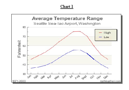 Eastern Washington coldest months are also November through March. Using Spokane Washington as the example, the coldest overnight lows are well below freezing in the 20’s. December and January are the coldest months with an average low of 21.6 degrees. Conversely; the warmest months are July and August with and average high of 82.5 degrees. Looking at the average overnight low for the year in Spokane is 37.1 degrees. The yearly mean high temp is 57.3 degrees. Clearly the location of Seattle on the Western side of the Cascades shows much less variability in temperature range for both the summer and winter season due to the influence of the maritime air form the Pacific. The Eastern part of the state show much more variability in temperature range form the summer to winter for both highs and low due to continentality of the location, and the source regions of the air masses. See Chart 2 below for average temperature range for Spokane. 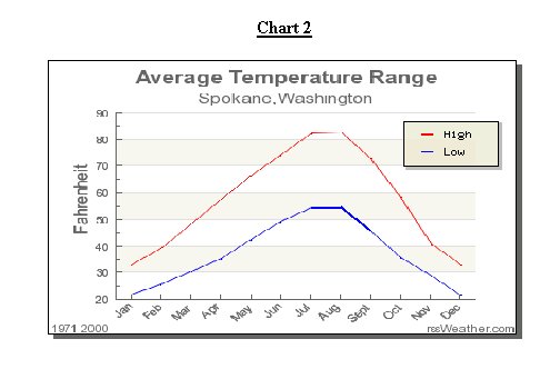 This is also true of the precipitation regimes for both Western & Eastern Washington. Western Washington has its wettest months are October through March, and the driest months are July and August. Seattle’s wettest month is November when the average rainfall is 5.90inches of rain to .79 inches in July. Overall for the year Seattle receives about 37 inches of rain a year or 3.08 inches a month. See chart 3 below for average monthly precipitation for Seattle. 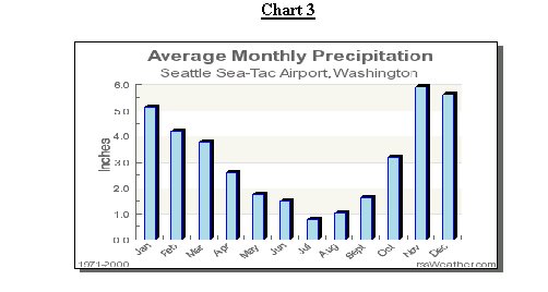 In Spokane in Eastern Washington they are quiet a bit drier than Western Washington. Spokane’s wettest months are November & December, and there driest months are July August, and September. In both November & December the average rainfall (or rain equivalent because most of the precipitation falls as snow) is about 2.25 inches of rain (15inches of snow equivalent), and the driest month is August when Spokane only receives .68 inches of rain, and only .76 inches in August, and September. The mean average for the year is 16.67 inches of rain for the year or about 1.3 inches per month. See chart 4 below for the average monthly precipitation for Spokane, Washington. 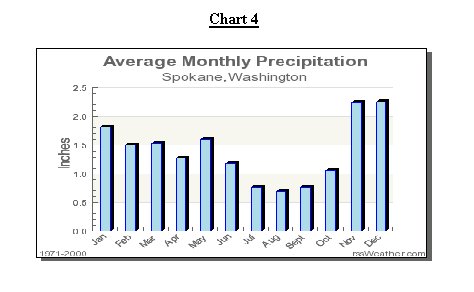 So looking at both the temperature and precipitation regimes in Western Washington and Eastern Washington it is clear the difference to there weather patterns. Western Washington is under the influence of the Maritime air from the Pacific which creates very little variation in temperature through out the year, and a fairly consistent amount of precipitation that occurs through out the year with the exception of July & August. Ultimately Eastern Washington sees much more extreme temperature variation, and much less in the way of precipitation, than Western Washington. The greater annual temperature variation, which causes quiet a bit of snow to fall in the winter time as apposed to rain, but over all looking at liquid equivalent of precipitation Spokane and all of Eastern Washington receives much less than Seattle or Western Washington. It’s these differences air mass source regions, and topography that create not only very different climates for each half of the state, but it also poses great challenges for those brave Meteorologists that try to forecast for the region. |