
I was first introduced to the microclimates of San Luis Obispo County, California in late 1994. I was 24 years old, and had just accepted the weekday morning weather position for the NBC affiliate in San Luis Obispo. As a newbie to the weather team, I wasn't all too familiar with the equipment, and had the help of a weather producer on my first day. She made maps and quickly left the station around 4am. An hour later, while preparing for the broadcast, I skimmed through the forecast graphics and saw something like this: TODAY'S HIGHS FOR SAN LUIS OBISPO COUNTY 63 to 102 degrees Surely, there was a big mistake here. My producer obviously meant the daytime high would be 102 with a nighttime low 63. It didn't seem possible that in one single county, you could have such a difference in daytime highs! Unfortunately for me, there was no way to contact her for clarification. She didn't have a cell phone and didn't leave her home number. The station's weather wire was dead, and the difax machine was also kaput. Keep in mind; this was long before the Internet was commonplace-so my ability to perform quick research was impossible. Desperate, I changed the graphics myself, and mentioned to viewers that the high would be near the century mark with the low in the lower to mid 60s. Moments later, the phones were ringing off the hook at the station's switchboard. The graphics I had changed were originally correct, and here I was, my first day on the job, royally screwing up the forecast with my ignorance. I had learned my first lesson about the weather of Central California the hard way. It was a lesson I'd never forget. THE FORECASTING PROBLEM What I eventually discovered, was that to accurately forecast the weather for San Luis Obispo County, California, one must have an understanding of several key things: the location of the forecast cities in the region, the topography, and how both are influenced by the Pacific Ocean. The mix of these features makes San Luis Obispo County a climactically diverse and special place for the people of this region. For the sake of this paper, let's examine two cities along the western border of San Luis Obispo County, and two communities on the eastern side, and two more towns that are centrally located. Let's also look the summer seasonal temperature differences-as they offer the most contrast between locations. 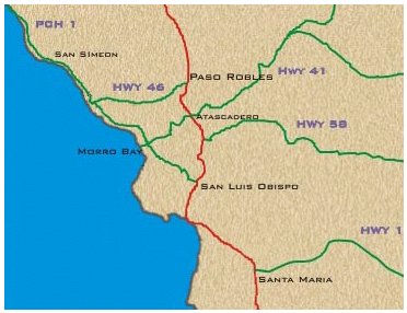 THE SHEER NUMBERS To the west, you'll find the coastal towns of San Simeon, and Morro Bay. During the summer months of June though August, both spots average high temperatures in the low to mid 60s (San Simeon, 62.3 F, Morro Bay, 65.2 F). Nighttime lows drop into the low 50s (San Simeon, 50.1 F, Morro Bay, 51.8). Not much separation between the highs and lows, huh? Towards the middle of the county average summer temperatures in San Luis Obispo (high: 77.5 F, low: 51.9) and Santa Maria (high: 72.2 F, low: 52.2 F) are considerably warmer, but the nighttime temperatures are a bit cooler than what you'd find along the coast. However, less than 20 miles to the east, average summertime high temperatures are even hotter in Atascadero (high: 90.8 F), and Paso Robles (high: 91.6 F). The contrast between the average highs in these towns and the summertime nighttime lows is even more dramatic (Atascadero average summer low: 49.5 F, Paso Robles average summer low: 52.3 F)! 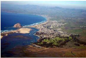 LOCATION, LOCATION, LOCATION So what causes these towns to record such variance in temperature? Look at the location of each city. Both San Simeon and Morro Bay are located along California's Central Coast. Just offshore, the California Current runs southward along the coast. Like an oceanic conveyor belt, it brings a blast of cool water from the Gulf of Alaska. The timeless movement of this current and the heat capacity of water have a moderating effect on the seaside communities-keeping temperatures from getting too high or too low. Their close proximity to the cold ocean water also causes these coastal towns to often experience thick fog and occasionally a dense marine layer-which can sometimes move farther inland to Lompoc, and San Luis Obispo. 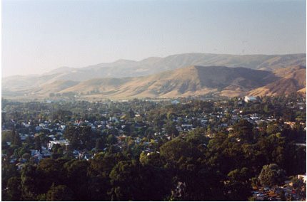 The City of San Luis Obispo. The Santa Lucia Mountain Range can be seen in the distance. Both in Santa Maria and San Luis Obispo, the climate certainly benefits from the Pacific Ocean, however, the influence isn't nearly as strong as observed along the coast. Both towns are a few miles from the beach, and surrounded by hilly terrain. When the marine layer creeps inland, the thick cloudbank can meander around the highest hillsides, and may significantly affect high temperatures-keeping the sun's radiant energy from warming the landscape. But even without the layer, the sea breeze will often be felt in each town. During the summer, this inflow of mild air keeps temperatures from seldom rising higher than 80 degrees. East-northeast of Santa Maria, and San Luis Obispo, the topography changes dramatically. The Santa Lucia Mountain Range quickly rises some two thousand feet in less than a two-mile span. On the other side of this fetch of peaks, you'll find Atascadero, and Paso Robles. The mountain chain that separates these eastern towns from the rest of the county is a tremendous climactic barrier-it blocks all significant influence of the maritime air, allowing these towns to achieve the highest daytime highs and the lowest nighttime lows in the region. These municipalities never benefit from an ocean breeze or rarely from the marine layer. During the dry summer months, the combination of high temperatures and low humidity tends to dry much of the vegetation, making much of the area susceptible to wildfires. 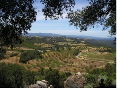 WHAT MAKES THIS PLACE SO SPECIAL? The microclimates in this region provide an amazing tapestry for agriculture. The wine industry is enormously successful. The cooler climates along the coast, with ample moisture from the ocean, have proven beneficial to vintners growing Pinot Noir grapes, and Chardonnay. The extreme heat in vineyards across eastern San Luis Obispo County increases the sugar content of the grapes-perfect for makers of the sweeter dessert wines like Rieslings or white wines like Zinfandels. See Canyon, a small community due west of San Luis Obispo is a hot spot for Jonathan apples. The production of Chandler strawberries has been booming near Santa Maria, in the southwest corner of the county thanks to the cooler conditions. Cattle ranchers have been thriving, raising beef on the hot and dry plateaus just east of the Santa Lucia Mountain Range. 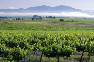 For the non-farmers, these diverse climates offer something most Americans can only dream of when it comes to weather: choice. If you live in a place like Paso Robles and you're not enjoying clear skies and 90-degree summer heat, a 25-minute drive to the southwest on highway 101, will bring you to 77-degree temperatures in San Luis Obispo under partly cloudy skies. Just 10-minutes more in the car will transport you to 62-degrees, with low clouds and fog in Morro Bay. At the same token, if you're sick of the overcast conditions and salty air of San Simeon, a 30-minute drive east will bring you to sunny conditions and 90-degrees in Atascadero. When it comes to weather and climate in San Luis Obispo County, you certainly have options as a resident-and plenty of challenges as a forecaster. |