
The greater Seattle area is one of the more challenging regions to forecast weather accurately. Rarely can we generalize or broad brush the prognosis. It's the Costco of meso-scale environments… everything imaginable and all under one big roof. The weather is spun every which way by two huge mountain ranges, by large and small bodies of salt water, several large freshwater lakes, and of course the region's most dominating weather force; the nearby Pacific Ocean. The landscape that makes this area so beautiful and unique, also controls how likely you'll be able to enjoy or even see it. 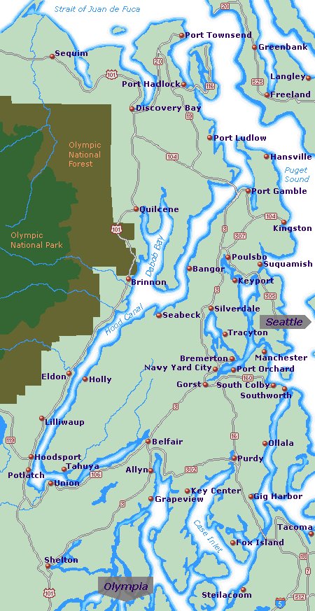 This paper focuses on one of those intriguing meso-curiosities… the isolated and thin band of sea-level snow that tends to fall on the lee side of the majestic Olympic Mountains while neighboring areas at equal elevation get rain. The target of my investigation is Hood Canal, a deep saltwater fjord 18 nautical miles west of downtown Seattle, and 20 nautical miles northwest of Tacoma. It's a narrow, hook-shaped canal, generally running north-south, on the eastern downwind side of the Olympics, which stand as a dramatic snow covered wall to incoming Pacific storms. Now by all I've learned it would seem that the east side of a Pacific coast mountain range would usually be the lee side, and lend itself to warm, down slope Chinook winds that would do nothing but dry out and warm up the Hood Canal basin as the descending air heats adiabatically on the east side of the Olympics. It turns out that's just one of several meteorological misconceptions for that area. The other misleading component is the conventional belief that at sea-level the heat capacity of an ocean-connected body of water such as Hood Canal would moderate surface temps to a point that snow would be rare and certainly not stick around if it did fall. Snow is uncommon for most Washington state coastal communities. Coupling a lee side of a mountain range with a sea-level climate should spell the same type of mild drizzly weather seen a little farther east in Seattle when the ocean fronts arrive under a westerly flow. Not always the case for Hood Canal. I've lost count how many times we hear from viewers reporting several inches of snow on the canal, while nearby Seattle and Tacoma are getting warmer drizzle. When our forecasts focus on the metro rain, those watching us from the canal cry foul. When we talk about their flurries, the neighboring urbanites ask, snow? What snow? So let's expose the forecasting pitfalls that can make Hood Canal weather so hard to predict. First, it's the water, or lack thereof. Yes Hood Canal is salt water at sea level… but it's only a mile and a half wide, about the size of a large mid-west river. That's just not enough water to have the same moderating temperature influences of the broader Puget Sound, nor the vast Pacific Ocean. National Weather Service forecaster Ted Buehner in the Seattle NOAA office says that narrow body of water allows radiational cooling to happen much faster than over communities like nearby Seattle and Tacoma that sit along the wider Puget Sound. The other red herring in all this is the assumption that Pacific storms always send westerly wind into the Olympics, making the east side of the range the lee side. In fact, the University of Washington has studied various extratropical cyclone wind patterns affecting Hood Canal that make it a little more obvious how the isolated snows get started. When low pressure sits over the eastern Pacific, but southwest of the Olympics, and high pressure dominates eastern Washington (east of the parallel Cascade mountain range), a pressure gradient sets up that replaces incoming ocean air from the west with wind from the east and south east. This results in a colder precipitation event that runs around to the back door, or eastside of the Olympics. Simply put, the windward and the leeward sides of the mountain range switch places. With that reversal, wrap around wind is now directed toward the east side of the mountains along the canal. The rest is elementary… orographic lift creates low-level, adiabatic upslope cooling along the Hood Canal shoreline. This is the first step in creating a colder precipitation event on what was once the leeward, but now the windward side of the Olympics. 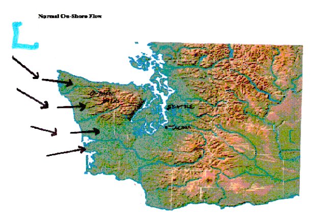 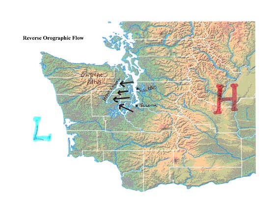 But what else contributes to the cold air component? If Seattle and Tacoma are too warm for snow… what makes the drops turn to flakes so close by, and at the same elevation? Sure there's the quicker radiational cooling from the narrower body of water, and the big cities certainly have an urban heat component… but something else comes into play. Remember Hood Canal is a true fjord, with tall mountains on one side that dive steeply right into the water, and very high bluffs on the opposite side of this narrow channel. KIRO TV meteorologist Rebecca Stevenson blames that topography for making it difficult to scour cold air from the Hood Canal basin. NWS Meteorologist Buehner agrees, and adds that a lower wet bulb zero level is also common in the Hood Canal snow scenario. Cold air often flows back downstream from the mountain tops into the fjord; dropping temps to 32 Fahrenheit while nearby Seattle and Tacoma have 36 degrees. It's similar to the phenomenon that chills the Nisqually Valley near Olympia Washington as cold air rolls downstream from Mount Rainier. A dome of cold air settles in over the slopes next to Hood Canal. This meso-scale snow event occurs 4 to 6 times a year on average… but the wild winter of 2007-2008 saw 8 such incidents…. most of which brought six inches of snow to Hood Canal, while a short distance away, Seattle and Tacoma got zero. Nailing this tricky forecast is important… it affects many people… and more each year. Hood Canal is home to the U.S. Navy's Bangor submarine base and its fleet of Trident nuclear subs. 10-thousand military personnel and civilians work there. Add to that the growing number of city people fleeing to the quieter, calmer environs of the canal, and you can see this is rapidly becoming an important zone to include in our daily forecasts. Important yes. Easy? No. As the Weather Service's Buehner says, "Forecasting snow (and its quantity) in the lowlands of Western Washington is always a challenge. Our weather around here is terrain driven, which is why it is so different from one area to the next to the next." Hood Canal takes those terrain differences to the extreme. But forecasters who take the time to consider all the variables that drive that mesoscale environment, especially the reverse wind direction and winter orographics, will likely have less trouble with that challenge. References and Sources Ted Buehner National Weather Service Office, Seattle WA Rebecca Stevenson KIRO Television, Seattle WA Interaction of an Intense Extratropical Cyclone with Coastal Orography W. James Steenburgh, Clifford F. Mass 1995 University of Washington Atmospheric Sciences, Seattle, WA, |