
Tule fog is a widely discussed weather phenomena in California's Central Valley. It gets its name from the tule grass wetlands of the region. The persistent dense fog is most commonly associated with the southern San Joaquin Valley where it can persist for days. For the purpose of this study, we will examine the ingredients that can lead to a busted valley fog forecast a bit farther to the north in the greater Sacramento region. This includes the extreme northern portions of the San Joaquin Valley (including Stockton and Modesto) and the southern Sacramento Valley (including Sacramento & Yuba City). Forecasting Tule fog in this northern region comes with a unique set of intricacies due to the local topography. The local fog season runs from November through March. During this late fall / early winter time frame, the nights are longer allowing for more significant ground cooling and a more pronounced inversion. This also marks the rainy season in California's Central Valley. It is on the clear and calm nights that follow a good rain event when all the ingredients are in place for widespread dense fog. Those ingredients include a moisture source (to help saturate the air), clear skies (for adequate radiational cooling), light winds (to prevent mixing) and a small dew point depression (to allow for water vapor condensation). The ground cools rapidly causing the moist air above it to cool and condense. The only way to dissipate this dense fog is to mix it out with a moderate wind or lift it with surface heating. At first glance, this may seem like a pretty simple weather event to forecast: moisture, plus clear skies, plus light winds, equals fog. In reality, it is still very easy to bust a valley fog forecast. Even with all of the ingredients in place you can end up with a fog-free morning. Or, you may wake up to dense fog on days when a key ingredient is missing. Because of the local topography, wind seems to be the most common fog ingredient to lead to a busted forecast. The soil and air can be completely saturated on a clear night with very light winds, yet the morning may still end up fog-free depending on the direction of those "very light winds." The valley is situated between the coastal mountains to the west and the Sierra Nevada Range to the east. Tule fog is formed when the dense mountain air flows down into the valley at night. Because of the strong temperature inversion that is created by this cold dense air trapped underneath a significantly warmer layer, light winds are typically unable to mix out the cold air and the resulting dense fog. However, a north wind can throw a wrench into this basic forecast rule. When a north wind flows down-slope of the Klamath and Cascade mountain ranges that mark the north end of the valley, it can have a drying affect. This, in turn, decreases dew points just enough to prevent widespread fog formation. In addition, a north wind commonly occurs behind an exiting cold front, which also leads to decreasing dew points. It is not the typical mixing impact you would expect wind to have on a fog forecast, rather it is the down slope drying affect. When forecasting fog in the area, it is imperative to take note of the forecasted direction of any wind. Even a light 3-5mph wind can prevent fog if it is out of the north. Yet, there are exceptions to this rule as well. Meteorologist Jim Matthews of the Sacramento National Weather Service recounts an occasion where a north wind picked up and simply pushed a dense fog bank south instead of mixing it out. "The general fog rule is south wind good, north wind bad� but there are always exceptions and it's the exceptions where we have a problem with our forecast," says Matthews. Another way to bust a fog forecast is to count on the rule that calm winds are a key ingredient for fog. It is actually not uncommon to see areas of dense fog on mornings with relatively high winds. Because of the variation of topography in this part of the valley, there are many wind-sheltered areas. It is here where dense fog can form in spite of 10-15mph winds. These locations are primarily along the east side of the valley and often provide some of the most dangerous conditions for drivers. Two of the most heavily commuted local roadways run east to west (I-80 and SR-50). On a day with a moderate valley breeze, mixing will provide a fog-free commute for miles along either roadway as commuters travel from west to east. However, as they approach the east side of the valley they can encounter a sudden wall of dense fog where visibilities drop to less than a quarter of a mile almost immediately. The fog may only stretch for a few hundred feet making it very difficult to detect on a fog or visibility product. However, during the height of a rush-hour commute, even a small patch of fog can greatly impact thousands of drivers. If drivers are unprepared to reduce speeds, an isolated area of dense fog can lead to major traffic collisions and even greater traffic delays. Those wind-sheltered areas are not the only locations where it is common to see unexpected patches of dense fog. One of the most important ingredients for fog is a moisture source. Interestingly, even in the middle of an extended dry period, the greater Sacramento forecast region is known to provide moisture sources of its own. The Sacramento River provides an ample moisture source that can cause dense fog formation for commuters along SR-50. Similarly, the I-5 / Hwy 99 corridor which runs north to south through the forecast area can see a similar fog situation. These roadways are flanked by the well-irrigated farmland of the greater Central Valley. Even if these areas have not seen any rain for weeks, the farmland can provide an ample moisture source of its own. On mornings where the ground is far too dry for widespread dense fog, a thin line of dense fog often forms right along much of this I-5 / Hwy 99 corridor. This happens to be one of the most traveled stretches of roadway in the state. Much like with the aforementioned wind-sheltered areas along I-80 and SR-50, this type of fog formation provides the added danger of unexpected visibility reductions on the roadways. On days when fog is widespread, valley commuters are typically trained to allow for extra time and expect reduced visibilities. However, they tend to be caught off guard on days like this where visibilities are not reduced until halfway into their commute. Matthews points out that the days with widespread precipitation-induced fog "aren't the days where we see the big problems and accidents." Accidents due to dense patchy fog are a leading cause of weather related casualties in California. One of the most notable incidents occurred in December of 1997. A wall of dense fog formed on I-5 near Elk Grove just south of Sacramento one Thursday morning. Visibilities were completely clear leading up to a huge fog bank where they were greatly reduced in a matter of seconds. A massive chain-reaction collision resulted, killing at least five people and injuring another 26. The accident involved nine big-rigs, another 27 cars and shut down one of the states largest highways all day. So it is easy to see the extreme consequences of a busted fog forecast. However, in spite of the dire consequences, there is not much in terms of expert opinion or research on the topic of forecasting Tule Fog. There are many articles on the occurrence of the phenomena and many more articles on the resulting accidents. However, I have yet to find any articles, academic or otherwise, on the forecasting intricacies and problems associated with the infamous fog. I suspect this is because there is no simple way to get around the difficulties of Tule Fog in the greater Sacramento region forecasting. So what can be done to better forecast this dangerous and common weather event? First and foremost, local forecasters must be aware of the key ingredients listed above that lead to a dense valley fog event. They should also have a thorough understanding of the local topography and how it impacts these various ingredients. However, even with this knowledge there is no guarantee when it comes to fog forecasting. Often the only differences between a fog forecast that verifies and one that busts are experience, a gut feeling and a little luck. 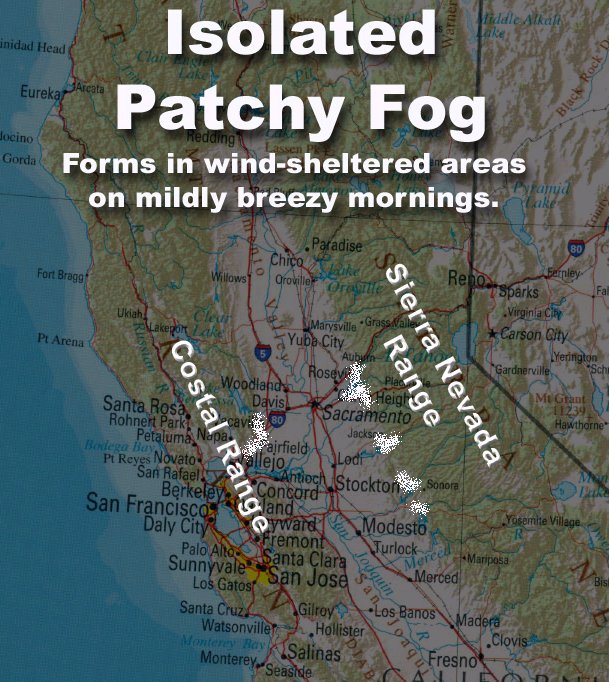 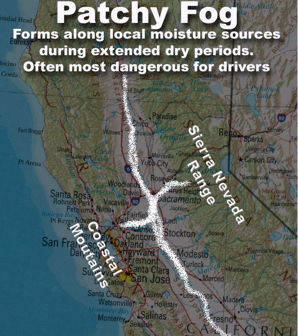 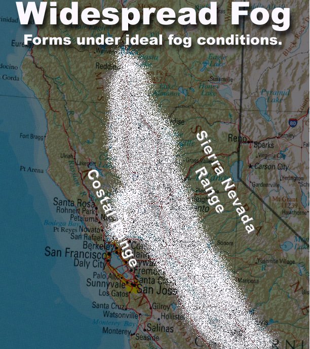 |