
A drought is considered a period of abnormally dry weather that causes a serious hydrological imbalance over an area. High temperatures and lack of precipitation can have devastating agricultural and economic impacts. It also forces local governments to place water restrictions on homes and businesses within the affected region. According to the U.S. Drought Monitor of North Carolina, 39 counties are experiencing exceptional drought; 32 extreme drought; 23 severe drought; and 6 moderate drought. State officials have deemed the condition the worst in recorded history. In 2007, the average rainfall deficit across North Carolina was 14 inches, and up to 24 inches in the piedmont and coastal plains. Farmers lost an estimated $382 million in crops in the past year. 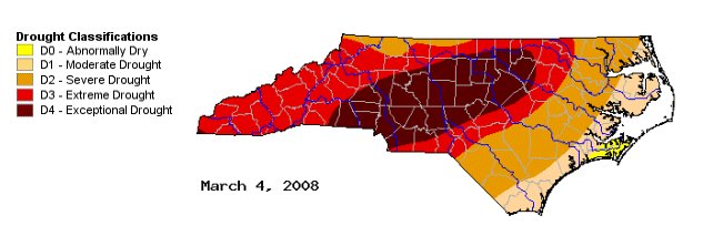 So what is causing this unusual weather pattern across the state? It is most likely the result of several ongoing factors. The major cause seems to be the La Nińa weather pattern, which is affecting the entire southeastern US. There is a strong correlation between sea surface temperatures in the Pacific and what happens in the Gulf of Mexico. The La Nińa pattern is an anomalous pattern of cooler than average sea surface temperatures across the central and eastern Pacific and warmer than average sea surface temperatures over the western Pacific. The jet stream created during a La Nińa event results in high pressure (ridging) just west of the United States. The downstream effect is that high pressure builds up over the southeastern United States, deflecting storms into the north. 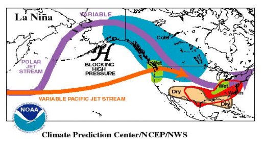 Researchers have shown that this pattern causes a sizeable reduction in storm systems tracking across the Gulf of Mexico, the ones that bring the most rainfall to North Carolina. The majority of the systems that impact North Carolina during a La Nińa pattern are Alberta Clippers. Alberta Clippers form on Alberta's high plains east of the Canadian Rockies. Once organized, they move quickly southeastward under the push of a northwesterly jet stream into Montana and the Dakotas, then turn across the Great Lakes basin headed toward the Atlantic Coast. This track, however, leaves them far from the moisture sources of the Pacific, Atlantic and Gulf of Mexico. As a result of their high forward speed and dryness, the average Clipper rarely deposits huge amounts of precipitation, dropping instead only a few hundredths of an inch of precipitation over North Carolina. 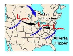 The National Weather Service expects the La Nińa climate pattern to continue through the spring. That pattern usually brings rainfall of 3 to 5 inches below normal in the six-month span covering winter and spring. It is rare for a La Nińa event to persist for two years or more. Long-term statistics suggest it is more likely that in the latter part of 2008, neutral conditions will prevail, with no significant cooling or warming of Equatorial Pacific sea surface temperatures. Another cause of the drought is the lack of tropical storms that had an impact on North Carolina in 2007. It was a slightly above-average hurricane season, with 15 named storms, 6 hurricanes, and 2 major hurricanes. While there were 2 landfalling category-5 hurricanes that made landfall in the Yucatán Peninsula of Mexico, the season had a minimal affect on North Carolina, strengthening the drought conditions. The state needs 12 to 18 inches of rainfall to ease drought conditions, the kind or rain that tropical storms could bring. According to Doug LeComte, a drought specialist at the National Oceanic and Atmospheric Administration's Climate Prediction Center, "A tropical system or slightly above average rainfall could alleviate much of the drought conditions. I don't want to be too pessimistic. Droughts do end, and sometimes surprisingly quickly. You never hope for a hurricane, but you might hope for the remains of one." 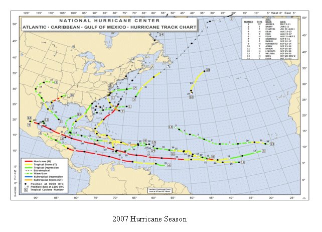 Or could the drought simply be the result of climate change? The Southeast experienced above normal temperatures in 2007. Last year had several months of above normal temperatures and extended heat waves. North Carolina measured its warmest August on record. The southeast baked under a strong upper-level ridge that persisted through the summer. The Raleigh and Durham area set a record with 83 days in which temperatures hit 90 degrees, more than double the usual 37. This caused greater evaporation, particularly during summer and fall, which added to the drought conditions. Forecasting drought conditions can be very difficult. Meteorologists determine the onset and the end of a drought by carefully monitoring meteorological and hydrological variables such as precipitation patterns, soil moisture, and stream flow. Meteorologists make use of various indices that show deficits in precipitation over periods of time. Prolonged droughts occur when large-scale anomalies in atmospheric circulation patterns persist for months, seasons, or even longer. According to the National Drought Mitigation Center, even scientists making use of General Circulation Models are no match for this complexity of all factors contributing to a drought. Current long-range forecasts are only moderately reliable. The wide variety of disciplines affected by drought, along with its large geographical and time scale, makes it difficult to develop an index to measure drought. Developed in 1965 by W.C. Palmer, the Palmer Drought Severity Index (PDSI) is an important climatoligical tool for evaluating the scope, severity, and frequency of prolonged periods of abnormally dry or wet weather. It has become the official drought index used by the National Climatic Data Center. The PDSI quantitatively compares the actual amount of precipitation received in an area during a specified time period with the normal or average amount expected during that same period. The PDSI is most effective in determining long term drought lasting several months, and is not as good with short-term forecasts. It uses a 0 as normal, and drought is shown in terms of minus numbers; for example, minus 2 is moderate drought, minus 3 is severe drought, and minus 4 is extreme drought. Parts of North Carolina are currently -3.58. As of March 2008, Raleigh has 107 days of water remaining. Increased water restrictions have reduced water usage across the state, but the demand will soon rise as spring arrives. Rising temperatures will increase evaporation rates and growing vegetation will decrease the ground water supply. The potential exists for drought conditions to worsen across the state in the coming months. References: http://www.ncdrought.org http://www.nhc.noaa.gov http://www.cpc.noaa.gov/products/analysis_monitoring/ensocycle/nawinter.shtml http://www.wrh.noaa.gov/fgz/science/drought.php |