
A drought is lower than normal precipitation that persists for a period of time. It takes months of above normal precipitation to make up for long-term deficits, causing draughts to take a while to go away. The year 2007 is one of the driest (if not the driest in some areas) years on record for much of the Southeastern United States. This year was Georgia's second driest, as the region experienced decreased lake levels and extreme rainfall deficits. A mere 31.85 inches of rain fell in Atlanta, Georgia throughout the year. That is just sixty-two percent of the average forty-eight inches the area is accustomed to receiving. Atlanta was only five one-hundredths shy of breaking the record of 31.80 inches of precipitation, set back in 1954. Droughts in Georgia have been documented by the U.S. Geological Survey (USGS) since the 1890's. The drought from 1903-1905 was the earliest recorded severe drought in the state. The drought of 1924-1927 was most severe in the north-central Georgia area, including the area in an around the city of Atlanta. Georgia saw similar drought patterns throughout the 1900s, with notable periods of drought including 1930-1935, 1938-1944, 1950-1957, and 1980-1982. The most severe period of drought was in the 1950s (hence the all-time record lowest precipitation recorded back in 1954). Drought is part of the natural cycle of Georgia's climatology. Most of Georgia sees drought recurrence intervals of somewhere around every 10-25 years. In general, Georgia can expect a two-year drought approximately once in twenty-five years and a drought lasting three or more years about once every forty years. Whether or not a particular area is more susceptible to a drought due to an increase in population and urbanization remains the question. Water-supply shortages first began occurring in Georgia in 1986, in cities such as Atlanta. During this time, the U.S. Army Corps of Engineers significantly decreased the release of water from Lake Sidney Lanier; however, reservoir levels continued to decrease to almost record minimum lake level, which occurred during the 1980-82 drought. During the 1985-89 drought, groundwater levels in northern Georgia were much less than normal and shortages in groundwater supplies from water wells occurred. Water shortages similar to those during 1986 occurred in the 1998-2000 drought as well as the most recent drought of 2007-2008. There are several factors responsible for the drought in the Southeast United States. First, the rainfall deficits in the North Georgia area began as a result of below normal rainfall back in spring of 2006. The South typically receives summer convective activity, and it brought some relief to the area, but the summer ended dry overall. The precipitation patterns of 2006 continued on and off through 2007. Atlanta only saw roughly eleven inches of rain from January through April, where it usually records at least twenty-two inches during this time period in a normal year. To make matters worse, a persistent jet stream pattern set up over the summer of 2007 that steered many storms away from the region. North Georgia also saw record-breaking temperatures throughout the summer of 2007. "Long stretches of hot temperatures and dry conditions increased evaporation rates and water usage across North Georgia." If lack of precipitation and record-breaking heat were not enough, the area also experienced an absence of tropical storms and hurricanes during 2006 and 2007. Tropical storms are a very important part of the annual rainfall budget for the Southeast, including the state of Georgia. The 2007 tropical season ended as one of the most inactive seasons since 1977. (Dobur, 2007) Another important contributing factor to the current drought in Georgia is the fact that Atlanta is a large city with limited water resources available. Metropolitan Atlanta depends on both Lake Alatoona and Lake Lanier for almost eighty percent of its water supply. Since construction of the Lake Lanier reservoir in the 1950s, the population of Atlanta has quadrupled and pressure has increased on what limited water is available in the reservoir. The outlook for spring shows some signs of possible relief, but officials worry about what will happen if the drought continues while the lakes are not adequately replenished. (See Figure below) 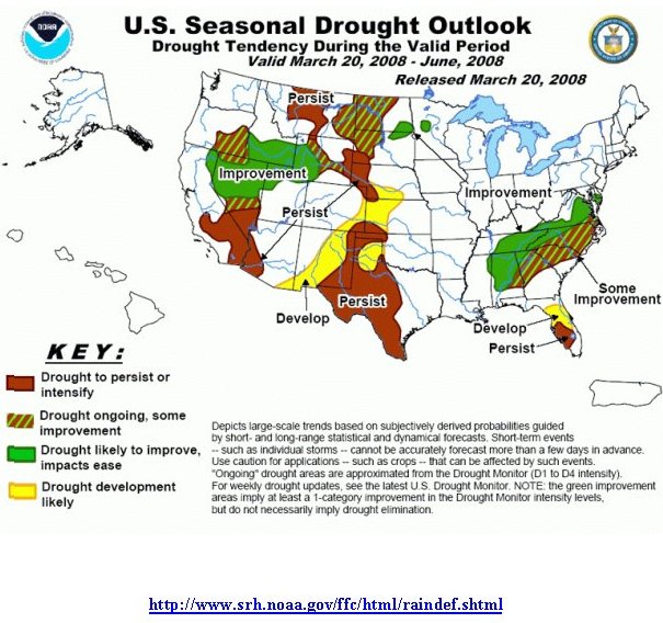 Forecasting periods of drought is extremely difficult to do until a drought is actually occurring. The National Weather Service and other private forecasting companies keep track of a deficit in precipitation and then compare the shortage with what is normally received at a particular location. Once a certain level of deficit is reached it is considered a drought. A drought is referred to as light, moderate, severe, extreme, or exception depending on how long the drought has gone on and the extent of bad effects from the lack of precipitation. The Atlanta Metropolitan area underwent a period of rapid population growth and vast urban and suburban development in the 1990s. The metro Atlanta area consists of twenty counties covering an area of nearly 6,100 square miles. Atlanta is #1 in the twenty most land-consuming metropolitan areas, ranked by land area developed between 1982 and 1997. Atlanta had an increase of 609,000 acres of new development, an increase of nearly eighty-one percent. Atlanta's population also boomed at this time, with a forty-six percent increase from 1980 to 2000. (See Figure below) 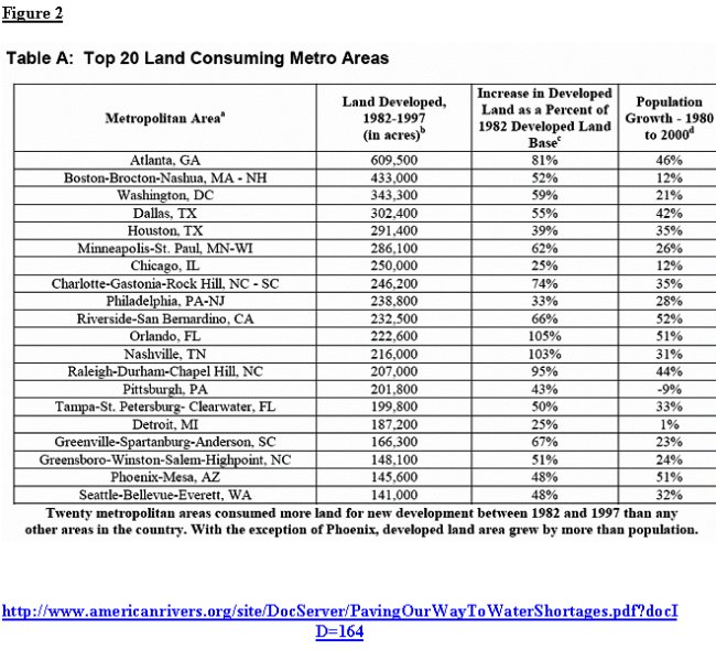 Studies in recent years have linked urbanization to the threatened water supply. Suburban sprawl contributes to polluted waterways as well as reduces water supplies. As surfaces characterized by growth (roads, parking lots, driveways, roofs, etc.) replace natural land such as forests, streams, and wetlands, rain cannot replenish aquifers any longer. A study was conducted in which researchers calculated the amount of rainwater that runs off the land instead of filtering through groundwater resources, comparing the year 1997 versus 1982. Results found that the potential amount of water not infiltrated in Atlanta was 56.9 billion gallons to 132.8 billion gallons. Atlanta's losses in 1997 amounted to enough water to supply the average daily household needs of 1.5 million to 3.6 million people per year. Since the area has continued to see a steady increase in development since the study conducted in 1997, one can only assume that the amount of water not infiltrated today is even more than that eleven years ago. (See Figure below) 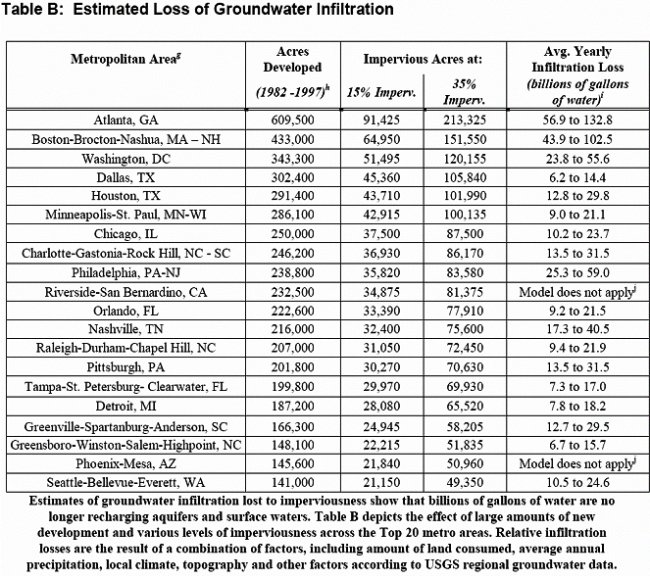  Urbanization threatens water resources at the time that demand for them is increasing. The building of roads in natural areas prevents rain from soaking into the ground. Under natural conditions, rain waters filter into the ground and feed rivers through springs, recharging the underground aquifers. However, the increase in paved surfaces causes precipitation to run off more rapidly and in greater volume. The result is a decrease in groundwater flow to streams, less recharge into aquifers, and an increase in the magnitude and frequency of severe floods. Construction of things we think nothing of on a day to day basis, such as a parking lot and bridges, cause major impacts on the way water makes its way back into the water cycle. "A one-acre parking lot produces 16 times more runoff than an undeveloped meadow." (Paving Our Way to Water Shortages) The population of the Atlanta metropolitan area is expected to increase from five million to nine million by the year 2030. Current water resources in the region may not be able to support this population increase unless developers make an effort to plan ahead. Right now the Atlanta area is under a Level Four Drought Response declaration for the sixty-one counties in North Georgia. This declaration prohibits most types of outdoor watering. Georgia Governor Sonny Perdue has declared a state of emergency for the area and has asked all resident to reduce water use by at least ten percent as compared to a year ago. Governor Perdue has also asked Georgians to reduce water use inside their homes and has ordered all state-owned facilities to do the same. There are well-established strategies, referred to as "smart growth," used for reducing the impacts of our development patterns. These strategies include the involvement of different community designs and regional patterns. Some of the principles of smart growth include mixed land uses, taking advantage of compact building design, preserving open space and farmland as well as natural beauty areas, and providing a variety of transportation choices. The Atlanta area could save a possible 245,338 acres of land by 2025 through the implementation of smart growth techniques. Taking small steps like redesigning parking lots to reduce the amount of runoff is just one of the many things the area can do to embark upon the goal of growing in the most environmentally safe way. Urbanization does have an effect on the severity of a drought, but is not the single cause of the drought in Georgia. Droughts in Georgia occur in 10-25 year cycles. A drought will occur despite how much land has been developed or how many people have moved into a particular area. Rainfall deficits and the lack of tropical storms in 2006 and 2007 contributed a great deal to the state of drought in Georgia. Studies show that urban sprawl does increase the amount of water that goes to waste and leads to water shortages at a faster rate than if the population were smaller and the area less developed. The Atlanta area has grown tremendously in recent years, and urban developers need to take heed of suggestion to help ease the negative effects of growth on the environment, in hopes of lessening the severity of future droughts. References Cech, Thomas V. "Drought." Principles of Water Resources, 2nd Edition. Massachusetts: John Wiley & Sons, Inc, 2005: 48-51. Dobur, Jeffery, "When Did the Drought Begin: A Focus on North Georgia and Atlanta Areas," http://www.srh.noaa.gov/alr/drought/Journal111607.pdf - November 16, 2007. "Drought and Water Use Information," Environmental Protection Division/Georgia Department of Natural Resources, http://www.gaepd.org/Documents/outdoorwater.html Metropolitan North Georgia Water Planning District http://www.northgeorgiawater.com/html/305.htm NOAA/ National Weather Service Forecast Office, "Drought Situation in Georgia…" http://www.srh.noaa.gov/ffc/html/raindef.shtml Betsy Otto, Katherine Ransel, and Jason Todd, American Rivers Deron Lovaas and Hannah Stutzman, Natural Resources Defense Council John Bailey, Smart Growth America "Paving Our Way to Water Shortages: How Sprawl Aggravates the Effects of Drought," http://www.americanrivers.org/site/DocServer/ PavingOurWayToWaterShortages.pdf?docID=164 Stooksbury, David E. "Georgia Drought," http://www.caes.uga.edu/topics/disasters/drought/ USGS, "Drought in Georgia," http://pubs.usgs.gov/of/2000/0380/pdf/ofr00-380.pdf |