
Cold air damming (CAD) is a synoptic scale weather event, resulting in the transport of a shallow layer of cold air trapped and channeled by mountains. If conditions are right, this can lead to the formation of a self-sustaining, prolonged weather phenomenon known infamously as, "the wedge." The wedge is hard to predict, and can exist as a separate mesoscale entity for days after the initial CAD has ended, inducing cool, cloudy weather in the warm months, and potentially significant icing events in winter. Wedges can occur any place in the world where mountain ranges exist. In the United States, two primary CAD/wedge locations are the lee of the Rockies and the lee of the Appalachians.(1) This paper focuses on the challenge of forecasting the development of a wedge, and examines wind direction at different levels to aid in that determination. While the synoptic nature of CAD events makes them easy to spot on forecast surface progs (visible in the northern hemisphere as kinked isobars nosing down the lee of north-south oriented mountain ranges, thanks to their higher air-pressure values in association with the denser cold air), forecasting the development of a resulting wedge is tough. This is due to the specific meteorological requirements in its initial stratus deck formation. (It is thus important to distinguish "the wedge" as a separate entity from "cold air damming." While CAD can induce a wedge, it is not needed to sustain it. The author commonly notices broadcasters using the terms "wedge" and "cold air damming" interchangeably, when, by definition, they are technically a separate phenomena.) 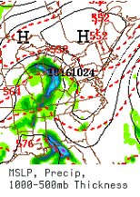
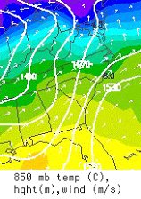 Models can usually predict the onset of a wedge, but commonly underestimate their duration.(3)(5) This author has found the key to a successful "field prediction" (a rough estimate) of a wedge's survival is identifying the proper wind direction angle needed to induce the formation of a the stratiform deck during the initial CAD event. Winds between the surface and the 850mb level must flow nearly opposite each other (180°) for the most efficient isentropic lift to occur on its potential temperature plain. The author has found that a difference in angle between the surface and 850mb must be within 30° of 180° for a solid-overcast stratus deck to form. Otherwise, limited cloud-cover subject to solar isolation and quick thermal modification can be expected. In the following example, we assume a CAD event is occurring at the surface: Forecast surface winds are northeast at 45°, and 850mb winds are southwest at 230°, the difference in angle (230° - 45°) is 185°, which is just 5° from the "ideal" of 180° difference - safely within the rough "30° rule-of-thumb" range, to best develop stratiform clouds through isentropic processes in CAD scenario. If this wind scenario occurs for a prolonged period (usually at least overnight, when solar insolation is at a minimum) stratus will likely form and a wedge is a good bet. In a "close, but no cigar" scenario, surface winds are northeast at 45°, and 850mb winds are south-southeast at 160°, the combined difference (160°-45°) is 115°, which is 65° from the "isentropically ideal" 180°, and 35° from the "stratus-forming standard" of residing roughly within 30° of 180°. Only broken clouds would likely develop, opening the region to solar-warming and quick modification of the newly advected surface cold. To illustrate a "non-wedge" scenario, common with some quazi-CAD events (like the occurrence of a "backdoor" cold front): Surface winds are northeast at 45° and 850mb winds are north at 0°. The difference in angle (45° - 0°) is 45°, a full 135° from the "ideal" combined difference of 180°, and 105° from the minimum difference to achieve our "30° rule-of-thumb." Mostly sunny skies would be forecast, and any cold air would quickly wash out within a day with solar insolation. If there was slightly warmer air aloft in this type of scenario, it would actually "fall down" the cold wedge, subsiding and further inhibiting cloud development. Studying winds in a CAD event to forecast the development of a a classic wedge will also give a forecaster the edge in determining if MOS predictions are at all realistic, or if drastically undercutting its forecast high temperature is appropriate. While this paper focuses specifically on rough "field forecasting" techniques associated with a classic wedge, it is important to discuss the "in-situ" wedge -- Latin for "where it stands" -- which forms in place over the Piedmont of Virginia and North Carolina in response to approaching low-pressure and its associated easterly pressure-gradient-induced winds.(1) This wedge does not require CAD, but instead adiabatic lifting. While in-situ wedges are not long-lived -- because the passing storm system which induced it will eventually sweep it away -- it is significant in that surface temperatures can fall below freezing in winter, resulting in potentially significant icing events when liquid precipitation overspreads the region. In warmer months, it can enhance local sheer and helicity levels, aiding in severe weather development.(4) The challenging and hard-to-predict character of the classic wedge can easily make or break a forecast, with only a slight change in wind direction. Great care and consideration are thus required to know when to "hedge on the wedge" if forecasting for "the [cold-air] dammed." SOURCES: 1) Wesley, Doug, Dr., et al. "CAD Module." University Corporation for Atmospheric Research; http://www.meted.ucar.edu/mesoprim/cad/index.htm 2) Fritsch, J. M.; Kapolka, J.; Hirschberg P. A. "The Effects of Subcloud-Layer Diabatic Processes on Cold Air Damming." Journal of Atmospheric Sciences, vol. 49, Issue 1, pp.49-70; Harvard-Smithsonian Center for Astrophysics Website; http://adsabs.harvard.edu/abs/1992JAtS...49...49F 3) Osterman, Martin. "Ice storms and what makes them..." The Star Press, Feb, 25, 2007. http://orig.thestarpress.com/blogs/ 4) Schneider, Doug, et al NWS RAH. "CAD Forecasting Tips." NWS/NC State University CSTAR Meeting. http://www2.ncsu.edu/eos/service/pams/meas/sco/research/ 5) Scott; Hartfield, Gail, NWS RAH. "CAD Forecast Tips." Page 38. NWS/NC State University CSTAR Meeting. http://www2.ncsu.edu/eos/service/pams/meas/sco/research/ |