
Introduction: An Alberta Clipper is born in the Canadian province of Alberta. ItÆs one of the most significant synoptic-scale winter weather phenomena affecting central North America. It occurs most frequently during December and January and substantially less during October and March. ItÆs defined as; a very fast moving low-pressure system, usually low in moisture content, originates in Alberta in the lee of the Canadian Rockies, and then travels southeastwards. Often the Clipper travels through Winnipeg, Manitoba. Formation: As a Pacific cyclone approaches the coast of British Columbia the lower-tropospheric wind flow crossing the Rocky Mountains increases. A lee trough will develop as a result. ItÆll remain stationary to the lee slopes and broadens as air warmed by descent is advected eastward. The approaching upper-level trough and its associated vorticity maximum produces cyclonic development within the lee trough. Once a cold front overtakes the lee trough the cyclone begins to move away from the lee of the Rocky Mountains. Track: Once the Alberta Clipper is formed east of the Rockies itÆll sail southeastward into the Dakotas and Minnesota, also effecting southern regions of Manitoba. It then steers across the Great Lakes, usually just north of Lake Superior, before progressing eastward into southeastern Canada or the Northeastern United States. Less that 10% of these storms track south of the Great Lakes. It usually moves very rapidly, generally at 50-60 kilometers per hour. 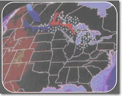 Precipitation: This course keeps them hundreds of miles away from any moisture source, so typically they donÆt deposit huge snowfalls. Alberta Clippers are generally regarded as rather small-scale systems, within the spectrum of extra tropical cyclones. Lack of available moisture and rapid movement produce relatively low precipitation amounts over a narrow band. However, several factors could combine to produce somewhat impressive snowfall totals, 15 centimeters (6 inches) or more. These factors include; access to more moisture, which could raise precipitation amounts, slower system movement, this increases snowfall duration, and colder temperatures, this increases the snow to water ratio. Other Precipitation Factors: Alberta Clippers love La Nina years. La Nina means the Jet Stream dives south across the Great Lakes. That can often mean areas surrounding the lakes are the only ones in the U.S. to see a white Christmas. The Great Lakes southern and eastern shores often receive enhanced snowfall from Clippers during the winter months from lake enhancement. Lake effect snow substantially increases snowfall totals. Also, if conditions are favorable, an Alberta Clipper can rapidly intensify off the East Coast. Once the storm taps the relatively warm moist air over the Atlantic Ocean, the storm sometimes spreads heavy snow over New England and Southeastern Canada. Wind: What the Alberta Clipper is most known for is itÆs strong, frigid winds. A mature Clipper can sport winds of 65 kilometers per hour with gusts up to 95 (40 miles per hour with gusts up to 60). ItÆs not uncommon for areas in the lee of the Rockies to sustain Chinooks as a Pacific Low approaches B.C. Over Central and Eastern Northern America; the region between the cyclone and the often-intense anticyclone trailing the Clipper experience the strongest winds. Enhanced winds associated with a substantial pressure rise and fall, and a downward transport of high momentum air in areas of strong cold air advection and low static stability produce strong winds. In the wake of the Alberta Clipper strong winds usually follow. With recently fallen fresh snow, blizzard conditions are common. Temperature: The push of the northwesterly jet stream tends to sail Alberta Clippers. Often these lows are followed by bitter outbreaks of polar air, which can continue for days after the low has moved off. The effects of an Alberta Clipper can be a drastic change in temperature. In the wake of the system the mercury could plunge by 16 degrees Celsius (30F) in as little as 10 to 12 hours. Strong northerly winds and bitterly cold temperatures leave behind dangerous wind-chills, ground blizzards, and days of whiteout conditions. Other Clippers: Two variations of Alberta Clippers are Manitoba Maulers or Saskatchewan Screamers. These two types of systems are far less common than Clippers, and even when they take place they are still often referred to as Clippers. The main difference between the three is from which Canadian province they begin their southward track. References: The Weather Notebook by Dave Thurlow of the Mount Washington Observatory: http://www.weathernotebook.org Wikipedia, the free Encyclopedia: http://www.wikipedia.org USA Today by Chad Palmer: http://www.usatoday.com ōA synoptic-Climatology and Composite Analysis of The Alberta Clipper,ö by Blaine Thomas and Jonathan Martin with the Department of Atmospheric Oceanic Sciences University of Wisconsin-Madison |