
GRAPHICAL AREA DISPLAY:
LCL (LIFTING CONDENSATION LEVEL)
| |||||||||||||||||||||||||||||||||||||||||||||||||||||||||||||||||||||||||||||||||||||||||||||||||||||||||||||||||||||||||||||||||||||||||||||||||||||||||||||||||||||||||||||||||||||||||||||||||||||||||||||||||||||||||||||||||||||||||||||||||||||||||||||||||||||||||||||||||||||||||||||||||||||||||||||||||||||||||||||||||||||||||||||||||||||||||||||||||||||||||||||||||||||||||||||||||||||||||||||||||||||||||||||||||||||||||||||||||||||||||||||||||||||||||||||||||||||||||||||||||||||||||||||||||||||||||||||||||||||||||||||||||||||||||||||||||||||||||||||||||||||||||||||||||||||||||||||||||||||||||||||||||||||||||||||||||||||||||||||||||||||||||
METEOROLOGIST JEFF HABY
The LCL (Lifting Condensation Level) is the height in meters above the ground surface at which a rising parcel of air first becomes saturated. This
level is found theoretically in several similar ways. A common way is to determine the average temperature and dewpoint between the ground surface
and 50 mb above the ground surface. Use these temperature and dewpoint values for a parcel of air that is force lifted from the lower PBL (Planetary
Boundary Layer: layer of air closest to ground surface where friction and thermal mixing is common). The elevation that this parcel of air first
becomes saturated (relative humidity = 100%) is the LCL. One assumption that must be made is that the lifting is occurring from the lower PBL, thus
the LCL is only relevant for lifting that is occurring from the PBL and not lifting that is starting higher aloft such as lifting that first
starts above the PBL. Thus, the LCL is most relevant to warm season convection that is helped in the initiation process by solar warming of
the ground surface in the PBL. LCL is not relevant for cool season convection that is initiated above the PBL or for any convection that first
starts above the PBL.
There are a couple of reasons why this value is important to operational meteorology. First, it gives an indication of how high cloud bases
will be. If the PBL is moist (high relative humidity) then cloud bases (the bottom of clouds) will tend to be lower in elevation and thus
closer to the ground surface when surface based convection occurs. A hot and dry PBL will lead to very high cloud bases and significant
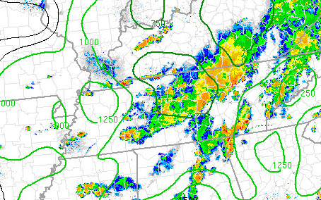
lifting will need to occur to lift the air high enough in order for saturation to occur. A LCL value of 1,500 m and especially less than
1,000 m is relatively close to the ground while a value greater than 2,000 m and especially greater than 3,000 m are relatively high. Second,
An LCL closer to the surface (assuming the LFC (Level of Free Convection, which will be further analyzed in next writing) is relatively close
to the surface also) indicates a greater potential for tornadic development. Of course, other factors such as wind shear and instability need
to be significant and influencing the lower troposphere. With no other limiting factors, a LCL and LFC close to the ground surface will allow
the region of CAPE and wind shear to be overlapped close to the ground surface. This makes it more likely a tornadic circulation can occur. The
image below is an example of LCL height shown over an area.
|
|
|