
At the surface, the wind direction crosses the isobars toward lower pressure. This occurs due to surface friction. Friction slows the wind and this causes the Pressure Gradient Force and Coriolis force to not be equal since a slowing wind is less influenced by Coriolis. Since the Pressure Gradient Force becomes greater than the Coriolis and since air flows from high toward low pressure due to the Pressure Gradient Force, the actual surface wind flows across the isobars toward lower pressure. The angle the wind crosses the isobars is more or less a 30 degree angle. This angle is less when friction is less but is more when friction is very high such as over a rough topographic terrain. The example below shows Montana and the isobars and wind plots evenly spaced. The pressure is higher over western Montana and lower over eastern Montana. This results in basically an anticyclonic wind flow pattern about the high pressure in western Montana. The surface terrain is rough thus you will notice the wind directions are crossing the isobars from higher toward lower pressure at 30 degree and greater angles. The isobars are fairly close together across Montana and this promotes stronger winds. Many of the wind plots have from 15 to 25 knot wind speeds. The network of station plots is often less over mountain regions and less populated regions. Highly changing elevations with fewer station plots can cause plotting inconsistencies in the data. This should be kept in mind when examining data based on equally spaced data points that are using interpolation techniques. 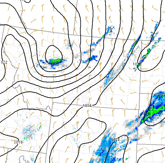 |