
Precipitable Water (PW) indicates the amount of moisture there is above a fixed point. It does not indicate how much it will rain but rather how much moisture is in the air. For example, a Precipitable Water value of 1 inch does not indicate it will rain 1 inch but rather indicates all the moisture above a location if condensed would be 1 inch. The Precipitable Water value is also an instantaneous value of the amount of moisture in the air above a location. It can precipitate more than the precipitable value amount since moisture convergence can occur and precipitation falls over a span of time and is not instantaneous. The Precipitable Water value gives a forecaster an idea of the amount of moisture in the air. Higher values indicate greater availability of moisture to make rainfall if precipitation develops. Below is a general guide to interpreting the Precipitable Water values: 0.50 inches or less = very low moisture content 0.50 to 1.25 inches = low moisture content 1.25 to 1.75 inches = moderate moisture content 1.75 to 2.00 inches = high moisture content 2.00 inches or above = very high moisture content Below are some forecasting implications of Precipitable Water. Severe Storms: Tropospheric moisture determines whether a supercell storm will be HP (High Precipitation), Classic, or LP (Low Precipitation). HP supercells often have PW of 1.75 inches or above and LP supercells often have a PW value of less than 1 inch. Flooding potential: A forecast area has a climatological normal PW for a certain time of year. In cases where the PW value is 2 to 3 or greater times more than the climatological value, flooding becomes more likely when a heavy precipitation event occurs. This often occurs in drier climates whose vegetation and land is not adapted to absorbing large amounts of precipitation. Lightning: In a high CAPE environment, high PW will lead to storms that produce an abundant amount of lightning. Updraft velocity: PW is the most significant contribution to water loading. Water loading reduces updraft strength since gravity tries to push the precipitation mass downwards-- against the momentum of the updraft. High PW also produces a heavier downdraft. The updraft being reduced is especially evident in a weak shear environment where the downdraft locates very near the updraft, thus destroying the updraft. Hail: High PW tends to reduce hail size since the updraft velocity is reduced. Classic supercells are often better large hail producers compared to HP supercells (HP supercells often form in very moist low elevation environment). Convective wind gusts: A high PW often occurs when the troposphere is fairly saturated. This can reduce convective wind gusts since convective wind gusts require dry mid-level air to add to their significance. Winter weather: It is more important for the troposphere to be near saturation than it is for the PW to be high in a winter weather situation since lifting, rather than instability release, is most important in precipitation generation. Cold temperatures limit the amount of PW. Winter soundings can have a low PW and still produce significant precipitation events if lifting and saturated conditions exist. The image below shows an example of a Precipitable Water chart with a radar image overlay. Higher values occur in air that has a higher average dewpoint through the depth of the troposphere. High dewpoints in the lower troposphere will aid in producing high values of Precipitable Water. Moisture advecting from a warm ocean such as the Gulf of Mexico will transport in significant amounts of moisture that will lead to higher values of Precipitable Water. Note the relatively high values over Georgia with values decreasing going north. 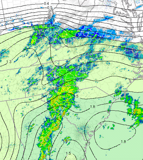 |