
METEOROLOGIST JEFF HABY
A polar high is a high pressure system found in higher latitudes in the cool season that develop over polar land masses. They can propagate
into the middle latitudes when the jet stream flow is conducive. They are strongest at the surface and weaken with height. The high pressure
at the surface is caused by dense cold air. Dense cold air sinks, thus it is the ground surface and lower portion of troposphere that
will experience the cold dense air. Often a trough will exist aloft above the polar high. This is due to the rapidly decreasing air
pressure with height. Since cold air is very dense, increasing elevations have more and more of the dense cold air (and thus the mass) below
it and this causes the pressure (and thus heights) to decrease quickly with height.
The region under a polar high tends to be very stable with a high surface pressure. Near the center of the high, the depth of the cold
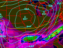
air is deeper and surface temperatures are very cold and the troposphere is very stable. The first image below shows a strong polar
high (surface air pressure with an impressively high 1047 mb) with no precipitation chances directly under the high. The second
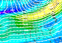
image shows the 300-mb image that shows the troughing above the polar high. The southern periphery of the polar high does have
precipitation chances since it is at the periphery where fronts and other lifting mechanisms will be present. The polar air tends
to decrease in depth as it moves into lower latitudes. This shallow cold air can be an ingredient for ice storms.
|
|
|