
| WX MODEL 16: Cold Air Retreat
| |||||||||||||||||||||||||||||||||||||||||||||||||||||||||||||||||||||||||||||||||||||||||||||||||||||||||||||||||||||||||||||||||||||||||||||||||||||||||||||||||||||||||||||||||||||||||||||||||||||||||||||||||||||||||||||||||||||||||||||||||||||||||||||||||||||||||||||||||||||||||||||||||||||||||||||||||||||||||||||||||||||||||||||||||||||||||||||||||||||||||||||||||||||||||||||||||||||||||||||||||||||||||||||||||||||||||||||||||||||||||||||||||||||||||||||||||||||||||||||||||||||||||||||||||||||||||||||||||||||||||||||||||||||||||||||||||||||||||||||||||||||||||||||||||||||||||||||||||||||||||||||||||||||||||||||||||||||||||||||||||||||||||
METEOROLOGIST JEFF HABY
After a cold air outbreak, when the trough associated with the cold air progresses away from the forecast area and a ridge progresses
into the forecast region, there can be a dramatic warm up. This warm up can be called a cold air retreat. The temperature can increase
rapidly over a short period of time and space. Clearing skies and thus sunshine can also aid in the warm up during the day. Another
mechanism that can contribute to the warm up is a downslope flow. This occurs when cold air retreats from a higher toward a
lower elevation. When these events are significant in magnitude they are called Chinook winds. Sinking air warms adiabatically. This
warming by sinking, along with sunshine and replacement by a warmer air mass, all work together to produce a significant warm up. These
events can help melt snow that fell during the cold air outbreak. The much drier air that is brought in can also evaporate the
snow as it melts.
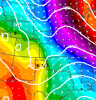
The 850 model image below shows cold air retreating over the central United States. The temperatures over Minnesota and Missouri are very
cold while to the west there is a dramatic warm up occurring over the states such as Texas, Colorado, Kansas, and Nebraska. Notice the
strong west to east temperature gradient across the map. Frigid temperatures are to the east and much warmer temperatures are to the
west. The gradual flow from the west over these western states is producing a warming downslope flow. The replacement by a warmer
mid-latitudinal continental air mass and abundant sunshine also aid in the warm up.
|
|
|