
METEOROLOGIST JEFF HABY
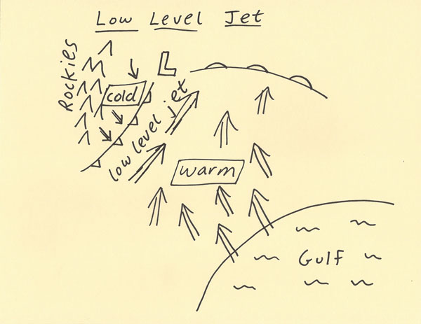
The low level jet is produced by the temperature gradient between colder high elevation air in the Rockies and high plains and the warmer air
farther to the east. In the higher elevations, the air cools at night due to cooling of the Earth’s surface. The same pressure level farther
to the east is at a higher elevation above the ground surface and is thus not cooled as much. The process that produces the low level jet
is like a mini version of the same process that produces the polar jet stream. The low level jet tends to be strongest in the early morning
hours since it is at this time that the high elevation land is at its coolest.
The low level jet can be enhanced by a cold front. The cold front intensifies the temperature gradient between the high plains and lower
elevation regions of the plains at a given pressure levels such as the 850 and 700 mb level. The diagram below shows a mid-latitude
cyclone induced low level jet out ahead of the cold front boundary. The low level jet tends to blow parallel to the cold front boundary.
These southerly type winds can rapidly transport heat and moisture from warm land and the Gulf of Mexico. The low level jet is
important for severe weather since it enhances Helicity, rapidly transports in heat and moisture and increases instability.
|
|
|