
| HABYTIME MINI LECTURE 66: THE POLAR VORTEX
| |||||||||||||||||||||||||||||||||||||||||||||||||||||||||||||||||||||||||||||||||||||||||||||||||||||||||||||||||||||||||||||||||||||||||||||||||||||||||||||||||||||||||||||||||||||||||||||||||||||||||||||||||||||||||||||||||||||||||||||||||||||||||||||||||||||||||||||||||||||||||||||||||||||||||||||||||||||||||||||||||||||||||||||||||||||||||||||||||||||||||||||||||||||||||||||||||||||||||||||||||||||||||||||||||||||||||||||||||||||||||||||||||||||||||||||||||||||||||||||||||||||||||||||||||||||||||||||||||||||||||||||||||||||||||||||||||||||||||||||||||||||||||||||||||||||||||||||||||||||||||||||||||||||||||||||||||||||||||||||||||||||||||
METEOROLOGIST JEFF HABY
The polar vortex is a term that became famous with the public in 2014. The winter of 2014 was particularly brutal for many parts of the
United States. Very cold outbreaks of air from the arctic were termed the polar vortex by some. “Here comes the polar vortex!”, was
a phrase that could be heard. But what exactly is the polar vortex?
In the winter, there is 24 hours of darkness at the North Pole and adjacent regions. High latitude regions that do get sunlight get diffuse
sunlight from a low angle and a short daylight length. This allows the land and frozen ocean to cool to very cold temperatures. Air
moving from the very high latitudes is influence by the polar easterlies. Easterly wind generally flows from the east toward the
west. Farther toward the south in the middle latitudes the upper level wind flow is influenced by the westerlies. Westerly wind
generally flows from the west toward the east. In the polar regions, very cold dense air builds at the surface. This helps create
troughing aloft since the region with the coldest densest air is more compacted. The influence of the polar easterlies and
mid-latitude westerlies can produce a vortex of very cold air and a strong cyclonic circulation. The polar vortex is nothing
unusual in the winter but what can make it seem more unusual is when the atmospheric flow pattern brings the circulation
far to the south and into the middle latitudes. This produces temperatures that are well below normal and icy and snowy weather. An arctic
outbreak can bring in record low temperatures, snow and ice to places where it is not too common, strong north winds, blizzards, heavy
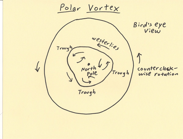
snow storms and extended periods of very cold weather. The diagram below shows where the polar vortex can develop and the upper
level flow pattern that can produce cyclonic circulations of air.
|
|
|