
The 1000 to 700 millibar thickness is the vertical distance in meters from the 1000 mb pressure surface to the 700 mb pressure surface. Thickness is primarily a function of temperature. As the average temperature of a column of air increases, then the thickness will increase because less dense air takes up more space than colder more dense air. Thickness values can be used to help forecast the precipitation type in a winter weather event. The 1000 to 700 mb thickness has the primary purpose of distinguishing between precipitations that will be rain or snow once it reaches the ground surface. The diagram below is a vertical profile of the troposphere from 1000 mb to 300 mb. Typically, the temperatures from 700 mb to 300 mb will always be below zero within this entire layer during a winter precipitation event. Thus, it is not as important to examine the temperature profile above 700 mb when it comes to forecasting winter weather precipitation type except for locations that are at high elevations such as mountain regions. For locations near sea level, it can be assumed the temperatures aloft from 700 mb and higher will be below zero when forecasting precipitation type. The 1000 to 700 mb thickness can give a forecaster an indication if snow will melt before reaching the ground or if snow will reach the ground. This value works best for locations that have an elevation of 1000 feet or less. This thickness index, while good at distinguishing between rain and snow, is of less use by itself when forecasting ice pellets or freezing rain (it will need to be combined with other thickness index values such as 1000 to 850 mb thickness, 850 mb to 700 mb and an EWL (Elevated Warm Layer) analysis in order to distinguish between other precipitation types. When the 1000 to 700 thickness is at 2,820 m or lower then it is very likely that snow will be able to reach the ground surface. Between 2,820 m and 2,860 is a borderline range in which precipitation could be snow, rain or a mixture of both. Once this thickness is 2,860 or higher then generally all snow will melt before reaching the ground surface. 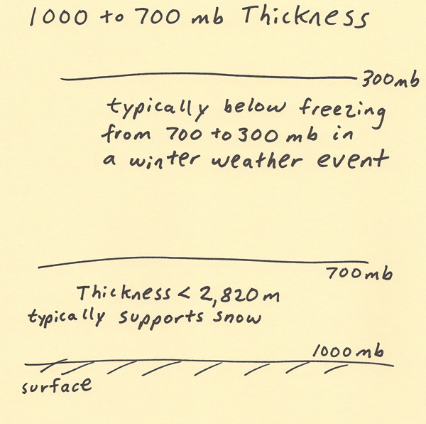 |