
There are two types of warm core lows that will be discussed in this writing. One type is fairly stable and occurs over hot land. The other has the potential to be violent and occurs over hot water. The fairly stable warm core low is termed a “thermal low” and the potentially violent warm core low is termed a “tropical low”. The warm core thermal low is shown below. It develops over hot land. Hot air has an inclination to rise since hot air is less dense than surrounding cooler air. This rising of the air produces a lowering a surface pressure. A thermal low is most intense at the surface but weakens with height away from the source region of the hot land. Higher aloft the air tends to be stable. Thus the rising motion from the surface is often not able to develop areas of precipitation due to the stable air aloft ending vertical motions that are initiated from the surface. Thermal lows are most common over subtropical dry land regions in the summer. Dry land tends to heat up more than moist land. This is another reason thermal lows tend to not produce much precipitation since they develop over dry land. In specific situations though, if the thermal low is able to draw in moisture from a moisture source, then afternoon thunderstorm type precipitation can develop. The warm core tropical low is shown below. In develops over hot water. Hot water is able to evaporate large amounts of moisture into the air. This moisture is what fuels the tropical low. Just as a thermal low, the tropical low is most intense at the surface and weakens with height. The upper troposphere will be fairly stable above a well developed tropical low. The strong convergence of hot and moist air at the surface results in intense thunderstorm updrafts near the tropical low center. The Coriolis influence organizes the updrafts into a circulation that rotates cyclonically around the center. The diagram below shows a tropical low that has developed into a strong tropical low. Features of this strong tropical low include strong convergence and updrafts circulating around the low center, an “eye” of sinking air at the very center, stable environment in upper troposphere that includes diverging wind flow that removes the mass of air that has converged in the lower troposphere, a strong surface low pressure center, and strong surface wind. 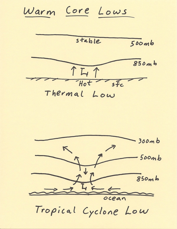 |