
There are four important categories of weather information to examine in a severe weather situation and these categories are moisture, lift, instability and wind shear. Moisture is the amount of water vapor in the air and when it comes to a typical severe storm situation it is the water vapor near the surface that is important to examine. Surface dewpoint is one important moisture chart to examine. It is interesting to note that the initial lack of water vapor higher aloft can be important to making a storm more severe (i.e. convective instability, negative buoyancy from evaporation of storm moisture into the dry air aloft). Lift is in reference to dynamic lifting. There are many that can be mentioned and examples include PVA, surface convergence, low level WAA, topographic uplift, frontal convergence, dryline convergence, surface low pressure system, jet streak divergence, sea breeze convergence, troughing, short wave, differential heating of surface, etc. Basically, it is important to know what lifting mechanisms will be in place and how powerful each will be (weak, moderate, strong). Instability is a situation in which if a parcel is initially lifted then it will eventually be able to rise on its own. Convective lifting is much faster than dynamic lifting thus in a severe weather situation it is one of the most important ingredients to study (i.e. LI, CAPE). Wind shear is a change in wind speed or direction with height. A forecaster will examine the turning of winds between the surface and 700 mb, the wind speeds in the upper troposphere (500 to 200 mb), and the speed of the wind in the boundary layer (low level inflow). 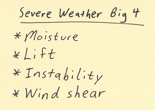 Moisture is an important ingredient to thunderstorm development. Precipitation, including heavy rain and hail, requires significant moisture. The air has the capacity to contain more moisture as the temperature increases. Thus, severe weather storm events occur more often when the weather is warm. High dewpoints (such as 55 F or higher, with the higher the better) in the boundary layer is an indication of good moisture. Also, moisture can converge along a convergence boundary. Thus, a storm has the potential to be supplied much more moisture than the dewpoint indicates. To have good low level moisture, typically the wind direction needs to supply moisture from a warm ocean source. Moisture can travel hundreds and thousands of miles away from its source region. Many of the analysis and model panels that a forecaster examines are for the presence and intensity of lift. Below are the model panels and the type of lift that is looked for. Multiple lifting mechanisms will increase the lift over any one individual lifting mechanism. Also, each lifting mechanism varies in intensity. Keep in mind that there are also sinking mechanisms and stable layers that a forecaster must study since they can counteract lifting mechanisms. The mechanisms listed below are just the lifting mechanisms: Surface chart- frontal convergence, sea breeze, dryline convergence, surface convergence, topographic uplift, differential heating, low pressure system (synoptic and mesoscale), etc. 850 mb- Convergence near the surface, WAA, low pressure convergence, etc. 700 mb- troughing convergence, short waves, low pressure system 500 mb- PVA, troughing, short waves 300 mb- divergence, jet streak divergence, troughing divergence 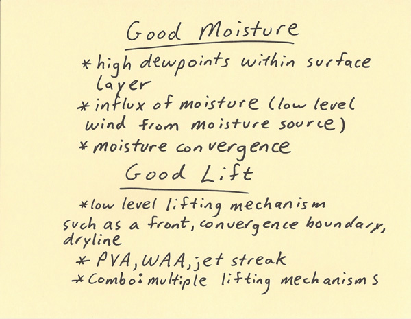 When it is known that storms WILL form, then analyzing the instability and wind shear are two important components for how severe those storms will be. Instability is commonly analyzed on forecast Skew-T plots. These can show how the instability profile of the troposphere changes over time. On this profile the LI (Lifting Index) and CAPE (Convective Available Potential Energy) are analyzed. Strong LI and Strong CAPE values indicate the updraft of a storm will be intense. This can lead to more intense rain, larger hail and stronger surface convective wind gusts. To have strong instability what is generally needed is warm/moist air in the boundary layer (surface to 850 or 700 mb) and cool dry air aloft (700 mb or 500 mb). Wind shear is the other very important component to turning a storm into a severe storm. There are three main points I want to mention when it comes to wind shear: 1. It helps to have moderate to strong winds in the boundary layer (such as being 20 knots or greater). If winds are too weak then this will reduce surface convergence and the ability for the storm to ingest warmth and moisture into the updraft. 2. Storms are more likely to be stronger if they develop in an environment in which the low level winds (surface to 700 mb) are turning with height (along with point 1 above). This directional shear helps twist the updraft which is one reason why wind shear is important to the development of tornadic storms. 3. Strong upper level winds (in about the 500 to 300 mb region). This helps remove mass from the top of the storm which both helps sustain the updraft and increases the updraft strength. It also helps prevent the downdraft from smothering the updraft. 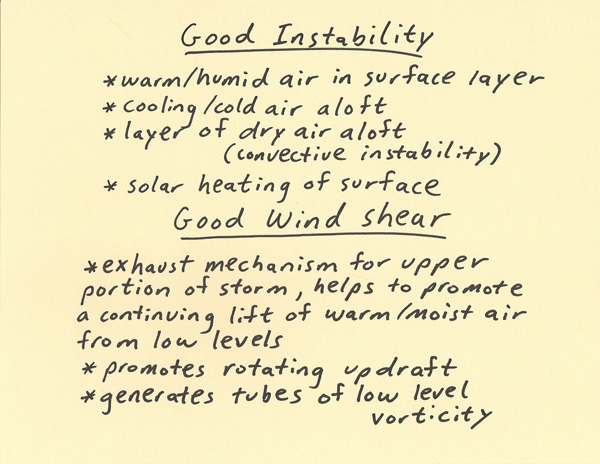
|