
A lifting mechanism is an atmospheric process that forces the air to rise. A lifting mechanism would NOT be thunderstorm convection nor any rising that results from rising air due to positive buoyancy. For an explanation of the difference between forced lifting and convective lifting see: http://www.theweatherprediction.com/habyhints/336/. This writing will examine five powerful lifting mechanisms. These lifting mechanisms are warm air advection, forcing along a density discontinuity, topographic uplift, low level convergence and upper level divergence. Often these lifting mechanisms act in conjunction with each other. Multiple lifting mechanisms when combined will produce powerful forced uplift. Warm Air Advection: Warm air advection on the whole is the most powerful lifting mechanism when it comes to the volume of precipitation in produces. Warm air advection can bring widespread stratiform rain. Warm air advection generated precipitation is common along and north of a warm front boundary and where warm-moist air wraps into a low pressure system. Below is a depiction of the common region warm air advection precipitation occurs in association with a low pressure system. The warm air advection moves to a higher altitude as it advects north of the shallow colder air north of the warm front. 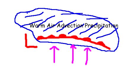 Forcing along a Density Discontinuity: Air with different densities do not readily mix. The more dense air will stay at a lower elevation while the less dense air will go over the top of the more dense air. Air that is more dense is more influenced by its weight and gravity and thus will sink or stay at the lower elevation. Because of this, when two air masses meet, the less dense air mass will be the one that is forced upwards. Examples of density discontinuities are cold fronts, warm fronts, outflow boundaries, drylines and air mass transition zones. Below is a depiction of less dense air rising over more dense air. 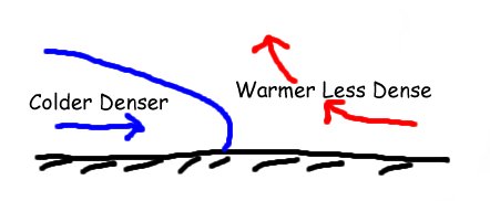 Topographic uplift: Topographic uplifts results from an extreme density discontinuity. The land is much more dense than air, thus when air moves into higher topography it must rise as the elevation of the topography rises. The windward side of high elevation regions receive abundant precipitation by this process especially if the air being lifting has an abundance of moisture. Below is a depiction of the topographic (orographic) lifting process. 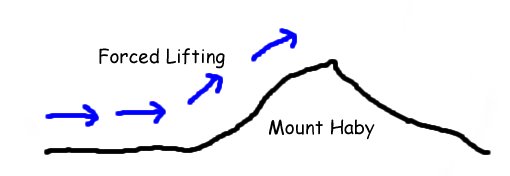 Low Level Convergence: When air at the surface moves together it must rise up since it can not go below the surface. This convergence occurs when faster winds move into weaker winds or air streams move into each other such as in the case with fronts and shear boundaries. Below is a depiction of uplift with low level convergence. 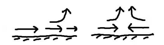 Upper Level Divergence: When wind speed changes aloft it creates a sort of vacuum effect in which air will be pulled upward from below. Two commonly analyzed upper level divergence mechanisms are jet streaks and positive vorticity advection. Each of these processes forces the air to change speeds aloft. Below is a depiction of upper level divergence pulling up air from below. 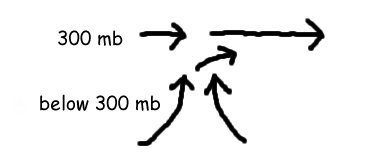 |