
| WHAT IS DIFFERENTIAL ADVECTION?
| |||||||||||||||||||||||||||||||||||||||||||||||||||||||||||||||||||||||||||||||||||||||||||||||||||||||||||||||||||||||||||||||||||||||||||||||||||||||||||||||||||||||||||||||||||||||||||||||||||||||||||||||||||||||||||||||||||||||||||||||||||||||||||||||||||||||||||||||||||||||||||||||||||||||||||||||||||||||||||||||||||||||||||||||||||||||||||||||||||||||||||||||||||||||||||||||||||||||||||||||||||||||||||||||||||||||||||||||||||||||||||||||||||||||||||||||||||||||||||||||||||||||||||||||||||||||||||||||||||||||||||||||||||||||||||||||||||||||||||||||||||||||||||||||||||||||||||||||||||||||||||||||||||||||||||||||||||||||||||||||||||||||||
METEOROLOGIST JEFF HABY
Differential advection is when there are two or more
air masses advecting at different elevations.
The two or more air masses will often have different wind directions and different source regions. For
example, continental tropical (cT) air from Mexican plateau advecting over and above lower level maritime tropical
(mT) air in Plains. For a second example, mT
air from the Gulf flowing over a warm front and advecting over the top of polar air to the north. If two air
masses clash with each other at the same elevation, the air mass with the lesser density will advect over
the top of the air mass with a higher density. Thus differential advection will cause vertical motions
when the less dense air mass has to move up and over a more dense air mass along a slope that forces
the less dense air mass to have a vertical component of motion. NWS forecast discussions will refer to
vertical motions produced by differential advection as
"isentropic lift". The classic cases for this is
a warm/moist wind flow along the slope of a warm front that forces the air to glide not just
horizontally but gradually upwards also.
Widespread stratiform precipitation
is common in that situation.
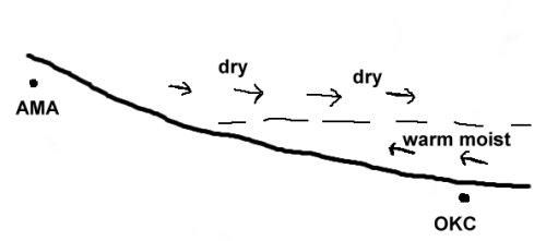
The diagram below shows differential advection occuring over the Oklahoma City region. Drier air from
Amarillo is advecting over the top of warm and moist air in Oklahoma.
|
|
|