
Clear air mode serves a few useful purposes. It is often used when no significant precipitation echoes are on radar, when light precipitation is on radar, or when the detection of subtle boundaries in the troposphere is desired. During clear air mode, the radar antenna ROTATES MORE SLOWLY. This allows for a finer resolution and heightened sensitivity of the radar. The goal of clear air mode is to detect "clear air echoes". Clear air echoes include dust, insects, birds, and even subtle reflection differences produced along boundaries in the troposphere due to temperature and moisture gradients. Clear air returns (returns that would not show on precipitation mode) are typically 5 dBZ or less. Only the lowest tilt angles are used in clear air mode. This is because most clear air returns are in the lower troposphere. Less actual tilt scans compensates for the fact that each tilt scan takes much longer in clear air mode (remember the antenna is rotating more slowly). Even though there are less tilt scans to make up a volume scan, a clear air volume scan still takes twice as long as a precipitation mode volume scan since the antenna rotates much more slowly to catch the fine details in the troposphere. Also in clear air mode the PRF is decreased. This allows the radar to detect echoes further from the radar site but also contributes to tilt scans taking longer and an increase of velocity aliasing. The precipitation particles clear air mode is used to detect are primarily drizzle and light snow. Since the antenna rotates much faster in precipitation mode, the reduced sensitivity does not allow the radar to detect fine particles of precipitation or particles of precipitation that have minimal reflections. Ice is less reflective than water with respect to radar energy, thus a finer resolution of the radar beam is needed in order to detect small snow crystals. Clear air mode can also be used to locate frontal boundaries and mesoscale frontal boundaries such as outflow boundaries, sea breeze fronts and drylines. A sharp moisture and/or temperature gradient in the troposphere sets up an interface of higher reflectivity (an example is to think of skipping rocks on water, the rock is reflective as it hits the boundary between the air and water). In a case where rapid refraction occurs, some of the energy will backscatter. Also, convergence occurs along frontal boundaries. Dust and insects tend to convergence along synoptic and mesoscale frontal boundaries. These increased regions of bugs and dust allow for a higher return on clear air mode thus allowing for the detection of these boundaries. Bird migrations can also be detected in clear air mode. The instructional image below shows lake effect snow using clear air mode. Notice how much of the returns are 5 dBZ or less. 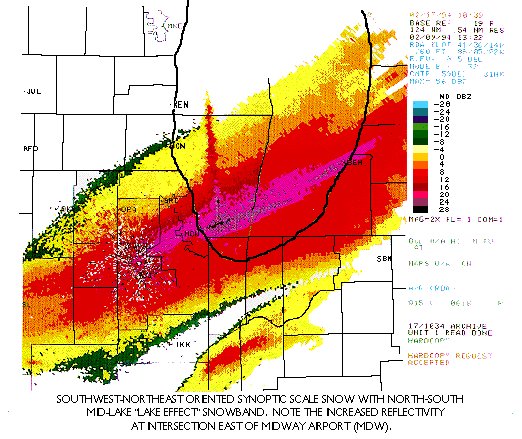
|