
A shear axis denotes a horizontal change in wind speed or direction. Convergence will occur when horizontal wind streams move toward one another. Strong wind speeds moving into a region of weaker wind can also do the trick. The following can create a shear axis: sea breeze front, outflow boundary, secondary surge of cold air behind cold front boundary, dryline, trough axis, and topography. On a surface chart, a dashed line denotes a shear axis. What is the difference between a shear axis and a front? A shear axis does not have as well of a defined synoptic scale temperature gradient from one side of the axis to the other. There can be a dramatic temperature and moisture difference on the mesoscale however. A shear axis represents a zone of convergence more than it does a boundary between air masses. A shear axis can be mesoscale or synoptic in size while a front is synoptic scale in size. Why are shear axes important? (1) They can act as a trigger mechanism for precipitation, (2) They can change a forecast significantly. Locating their presence is extremely important. 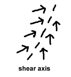 |