
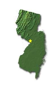
 The forecasting problem that I chose for this paper is forecasting winter and spring mixed precipitation in the central portion of New Jersey. While mixed precipitation can be a challenging endeavor for any Meteorologist, New Jersey's humid, warm-summer sub-tropical climate can bring about an enormous amount of variance in weather throughout the state. This variance can occur on a daily basis, but is especially observed on a seasonal basis. These differences will include a vast array of temperatures and precipitation due to the mesoscale influences across the state. The focus of this paper is concentrated on the difficulty in forecasting winter and spring precipitation. The precipitation during these times of the year can yield a number of mixed weather events including snow, sleet and freezing-rain. All of these produce a variety of dangerous conditions for the state's residents. These conditions can cause dangerous roads, electrical outages, school closings, and other events that can put the resident's lives at risk. The challenge to the weather forecasters includes predicting where these events will occur. This is difficult due to New Jersey containing five different topographical and sub-climatic zones. Each of these zones has different characteristics which influence weather processes in the other zones. According to the office of the New Jersey State Climatologist, the five distinct zones that divide New Jersey are as follows: The Northern Zone which includes the Appalachian Valley, and the Kittatinny Ridge and Valley. This zone is located in the northwest corner of the state. It will produce orographic precipitation as well as cold air damming due to its hilly terrain. It can rain here while the rest of New Jersey can be experiencing calm weather due to the subsiding air coming off the Northern Zone highlands. The Central Zone includes the northeast and central portion of New Jersey. The zone runs in a northeast to southwest direction from the New York Harbor toward Trenton, New Jersey. This zone produces an urban heat island effect in the summer months. One key aspect of the Central Zone is that the northern edge of the zone is often the boundary between freezing and non-freezing precipitation in the winter months. It is often the boundary between comfortable and uncomfortable heat and humidity in the summer months. This is the zone that is relevant to the forecasting problem being presented in this article. The Pine Barrens Zone located in the southern interior of New Jersey. This zone is dominated by scrub pine and oak forests. The sandy soil in this zone can emit large amounts of solar radiation which will lead to extreme low temperatures. The porous soil allows the surface to become very dry resulting in a wide range of daily highs and lows. The Southwest Zone is the driest and warmest zone with a maritime influence due to the nearby Delaware Bay. The soil is the least sandy, which causes the zone to experience the highest average daily temperatures and highest night-time low temperatures in New Jersey. This zone typically receives the least rainfall due to a lack of orographic features, and is located further from the Great Lakes-St. Lawrence storm track. It is also located far enough inland to avoid heavy rains from the New Jersey coastal storms. The Coastal Zone is a battleground between the continental and maritime influences. During the fall and early winter, the ocean is warmer than land. As a result, the coastal temperatures will be higher than the rest of New Jersey. In late winter and spring, the ocean keeps the coast cooler than the rest of the states. Each of the zones affects each other. In addition, the interplay between the zones is inconsistent due to the various features of each one. Therefore, forecasting mixed precipitation in the Central Zone is inherently quite difficult. 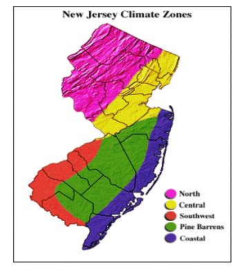 In order to forecast mixed precipitation in Central New Jersey, especially during the winter and spring, it is necessary to understand the atmospheric setup of the Central Zone. In this zone ground temperatures rarely stay at or below freezing for an extended period of time. However, they do freeze long enough to create a variety of conditions at the surface. The atmospheric setup will vary somewhat for each individual event, and includes a number of different profiles. The vertical profile of a column of air becomes extremely complex and varied and must be analyzed closely in a number of ways which are described as follows: A freezing rain event, which can be mixed with snow or sleet, must include a polar air-mass in place for a freezing to sub-freezing surface. At the same time warm-air advection from the southern reach of New Jersey or from the Atlantic Coast brings a maritime air mass above this surface layer. In the Central Zone, the antecedent conditions are also important to consider. The northern edge of this boundary will often mark a transition point of cold air from the hilly terrain of the Northern Zone to a slightly warmer air mass in the Central Zone. This cold air may advect southward to the Central Zone. In other situations, such as cold-air damming, it may stay north allowing the Central Zone surfaces to remain warmer. A sleet event which is similar to freezing rain and has many of the previously mentioned factors. A difference is that the freezing or subfreezing surface layer extends higher up vertically with a deep layer of polar air in place. This can be due to evaporative cooling which aids in keeping temperatures lower in the atmosphere. At the same time there will be warm air advecting above it. This can cause partial melting but the precipitation still falls as fine ice particles or pellets. This process is often a transition stage from a rain to snow event. A snow profile event is less complicated because the entire column of air keeps temperatures cold enough to avoid melting. This will depend on the track of the storm and antecedent conditions as well. In central New Jersey it should be noted that ground temperatures do not remain at freezing or below freezing for very long and usually any snowfall or mixed precipitation is melted within the next 24 to 48 hours. This includes grassy and natural areas as well. An expert opinion of these processes is Gary Szatkowski, who has served as a Meteorologist for the National Weather Service in Mount Holly New Jersey for the last 28 years. Mr. Szatkowski states that the most useful tool he has found in forecasting mixed precipitation is Skew-T soundings such as the "sleet sounding" and "freezing rain sounding", respectively, on the following pages: 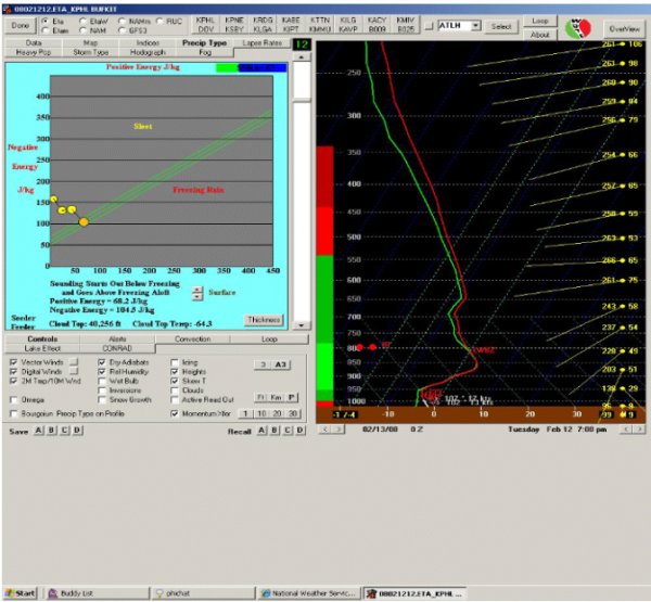 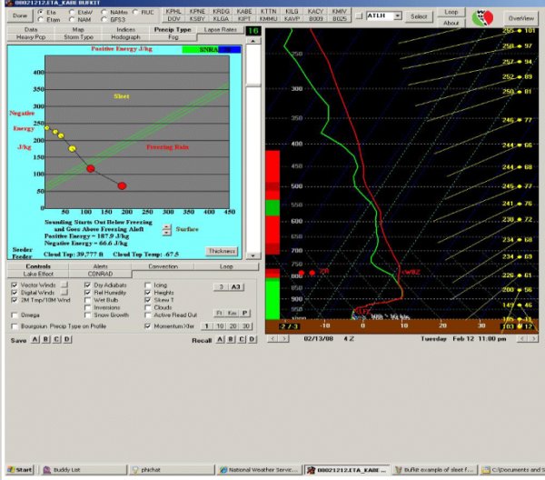 Mr. Szatkowski believes the advanced physics packages and numerical models lend themselves to a higher accuracy rate. He believes that one way to improve forecasting these events is through computer technology which he believes will likely continue to improve. However, his office is currently reporting a 90% accuracy rate in forecasting winter precipitation across the state. He often relies on the 925-850 millibar charts to assess temperatures, wind speeds and directions during a mixed-precipitation event. Mr. Szatkowski acknowledges the Central Zone of New Jersey as the primary "battleground" or division of many mixed weather events as compared to the rest of the state. On a mesocale level, Mr. Szatkowski uses the I-95 corridor as a general guideline when considering a mixed precipitation event. I-95 bisects the state in a Northeast to Southwest direction toward Trenton. Refer to the map on the following page: 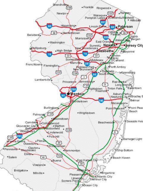 The area west and north of the I-95 corridor exhibits a hilly terrain which often times leads to cold air damming. This effect can keep temperatures cooler aloft and determine whether or not a rain event will reach the ground as snow, sleet, rain or a mixture. Ground temperature is another important factor to consider in forecasting mixed precipitation events. The temperature of the surface is dependent not only on terrain but incoming solar radiation and the time of day. Recall that in the Central Zone description, the area is very urban. This feature lends itself to many warmer darker surfaces which can retain more heat and cause melting or partial melting. If the weather-event happens during the day with breaks in cloud-cover, solar radiation can reach the surface during peak-heating at mid-day. As a result, melting can occur on the surface and produce a slushy condition. If the air above the surface is colder, the effect will be an ice-cover on anything that is slightly above the ground (such as trees and power-lines). However if the ground remains freezing with substantial cloud cover to block the solar radiation, black ice may form at the surface causing dangerous driving conditions in the area. This is especially true in the evening and night hours. In summary, forecasting mixed precipitation accurately in Central New Jersey requires knowledge of not only synoptic-scale events of the atmosphere, but of the column of air and its profile over a particular area of the state, the time of day, cloud cover, surface temperature, moisture processes and local terrain. Further, an understanding of the mesoscale processes, topographical influences and the Skew-T soundings are essential to assessing the forecast. As forecasters it is of utmost importance to continuously search for ways to improve our skills but these factors are the current items needed to forecast mixed precipitation in Central New Jersey. References Office of the New Jersey State Climatologist, Dr. David A. Robinson, link to website; Office of the New Jersey State Climatologist David Ludlum's New Jersey Weather Book, Rutgers University Press, New Brunswick, New Jersey, 1983, and also includes information from Climate of New Jersey, by the National Climatic Center, Ashville, North Carolina, and June 1982. Gary Szatkowski, Meteorologist in charge at the National Weather Service, Mount Holly, NJ, link to website; NWS, Mount Holly New Jersey Geology.com provided both state maps of New Jersey. |