
The state of Maryland has very unique properties that make forecasting the weather quite challenging. Those properties affect both temperature and precipitation. Although it is a small state, the weather changes rapidly from one city to the next- most times, we're talking about a distance of 30-60 miles. The forecast for one city is not the forecast for another. Therefore, when looking at synoptic and mesoscale patterns, a meteorologist must take many variables into consideration. We'll start with precipitation. The central portion of the state and it's main city, Baltimore, is considered a humid subtropical climate. The region gets frequent rainfall, averaging about 43 inches per year. Each month brings about 3-4 inches of precipitation.(*) This frequent precipitation has two main moisture sources- one from the east, and one from the west of the region. To the east, the Atlantic Ocean and the Chesapeake Bay provide tremendous amounts of moisture. When the wind flow is from the NE or the SE, clouds and moisture build and the precipitation travels inland until it hits the region's western feature. The Allegheny Mountains are part of the Appalachain Mountain chain. As the precipitation moves in from the east, the orographic flow makes for wet conditions on the eastern side, while the western side of the mountains will remain dry. Those mountains also provide shelter for much of Central Maryland when the wind flow is out of the west. A northwesterly flow brings in lake moisture from the Great Lakes region of the United States. In this case, orographic flow provides wetter conditions for the western side of the mountains, and much drier conditions for areas east of the mountains. This is especially true during the winter months, when much of that precipitation can be in the form of heavy snow in the mountains, but little more than flurries- or even light rain- to the east. In terms of temperature, the Chesapeake Bay moderates much of the state. In the summer it is not uncommon for a coastal city like Annapolis to read 75F, while just 10 miles away, Bowie might read 85-90F. The temperature contrast can be great over just a short distance, making for a tricky forecast. The reverse is true also in winter, where coastal cities and towns are a good 5-10 degrees warmer than areas in the central region of the state. The Bay creates foggy conditions as well. Some mornings, schools along the Bay and on "The Eastern Shore" of the Delmarva Peninsula delay the start of classes due to thick fog, while much of central Maryland experiences no problem. The city of Baltimore is often several degrees warmer than the suburbs. This is due to the urban heat island effect. Travel farther to the west, and the elevation rises as one approaches the mountains. Temperatures in the western regions of the state are often 10-15 degrees cooler than central Maryland. Sometimes there is as much as a 20 degree difference between Cumberland in Allegany County, and Essex on the Eastern Shore. The challenges of forecasting temperatures alone can keep a meteorologist on his toes! By far, the greatest challenge in forecasting for Maryland is the effect these two topographical features create when put together. The coastal plain and the mountains often create "coastal frontogenesis." A coastal front is a shallow (<1km deep), mesoscale frontal zone. This zone is marked by a distinct cyclonic windshift in a region of enhanced thermal contrast. The fronts develop inland when land is cooler than the ocean waters. This is most common in winter- and creates a rain/snow line. Generally, areas to the east of the front get rain, and areas to the west of the front get sleet and freezing rain. Predicting where that line develops is the key to an accurate forecast. Meteorologist James Lee, with the National Weather Service office in Sterling, Virginia, calls it "a balancing act. Where the coastal front sets up is the tricky part." On December 5th of 2007, a storm approached the state. It was a clipper system, coming in from the northwest. Predicting that precipitation depended upon how cold the air mass was when the storm arrived. Computer models predicted two different outcomes- one with rain, the other with a wintry mix. This is a situation where models just aren't that great with boundary layer predictions. Lee says that is due to lack of initializing and sampling. This is also where human experience and knowledge of your forecast region is a must for accurate forecasts. The region ended up with snow. The amounts varied greatly- with heavier accumulations in the west, and lesser amounts in the central region, and finally, sleet and rain on the Eastern Shore. One week later, another storm approached the state- this one from the south. The coastal front made the forecasting more difficult. Predictions started out as a mix of snow and sleet. The result was freezing rain and rain across most of the state. The ocean temperatures and air masses played a big factor. Lee says that "at 6,000 feet the air mass was just too warm to support any frozen precipitation." Municipalities, school districts, and commuters all depend on accurate forecasts, and missing the mark can be costly. Paying for snow crews on stand- by is expensive, especially if snow does not happen. Canceling school, or other events is also costly and inconvenient, not to mention infuriating when the forecast is incorrect. On the other hand, when rain is predicted, and freezing rain or snow is the outcome, highways become deadly. Models do not do well with coastal frontogenesis. There is not a great deal that can be done to improve them at this point. Perhaps more sampling stations can help- but in many cases, experience and intuition is going to be the best bet, along with very vigilant watch on the observation sites, satellites, radars and other tools. One area that has not been extensively researched, is the correlation between the fall line along the east coast of the United States and coastal frontogenesis. The fall line is where the land changes geographically from coastal plain to piedmont. Could that elevation change contribute to the coastal front formation? Baltimore is one of the cities on the fall line. Yet it is also a city located between coastline and mountain. Which is more responsible for the coastal front? If the front always sets up along the fall line, then prediction would certainly be much easier. Although Maryland, and the Mid-Atlantic region in general, is not known as a weather "hot spot," it is definitely a state with very diversified weather, and a unique set of challenges. A keen sense of the atmospheric profile, along with an extensive knowledge of topography is vital to an accurate forecast. Simply depending upon forecast models will, without a doubt, result in botched forecasts. In the world of weather, accuracy is the key. It not only equates with credibility, it can also equate with saving money and saving lives. 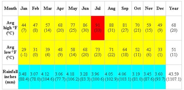 Source: The Weather Channel[26] 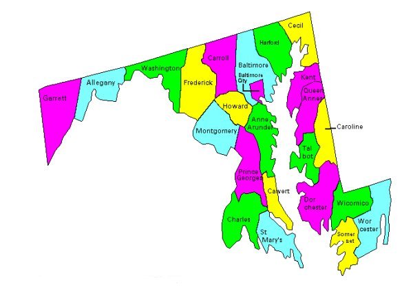 Map of Maryland, showing counties 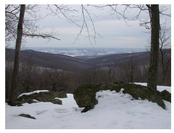 Alleghey Mountains, Allegany County, Maryland, courtesy Sierra Club 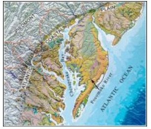 Map of Chesapeake Bay & Fall Line, courtesy USGS  Chesapeake Bay, courtesy Mary Hollinger, NOAA |