
Preface The Denver Convergence-Vorticity Zone has been studied since 1981 by various meteorologists, storm chasers and amateur weather enthusiasts. The numerous studies and analyses of each discipline have stemmed from a few different motivations. Meteorologists, especially those employed by NOAA, are most interested in protecting life and property in and near the Denver suburbs. Storm chasers wish to take advantage of film and photographic opportunities, and share their “catch” with the public. Amateur weather enthusiasts primarily focus on the basics of the phenomena with a general interest in spotting and predicting non-supercell tornadoes and severe weather events. The most comprehensive official study of the Denver Convergence-Vorticity Zone was done by Meteorologist Edward J. Szoke of the NOAA Earth Systems research Laboratory in Boulder, Colorado. Mr. Szoke has compiled extensive documentation of the wind flow patterns, overlain on terrain maps, to support the general accepted theory of this important warm-season circulation. An additional study was completed on the 25th anniversary of the discovery of the Denver Convergence Vorticity Zone in 2006 by Mr. Szoke, along with Dave Barjenbruch, Robert Glancy and Robert Kleyla of the NOAA WSFO in Boulder, Colorado. This paper will address the Denver Convergence-Vorticity Zone, (henceforth referred to as the “DCVZ”), from the perspective of storm chasers. The focus will be on the nomenclature, definition and theories of formation, and related severe weather. Finally, some strategies will be put forth for storm chasers to consider when attempting to study and photograph resultant non-supercell tornadoes and other circulations which can be a focal-point for the development of larger storms farther out on the Colorado plains. Discussion of Nomenclature and Terminology The DCVZ has recently been otherwise referred to as the “Denver Cyclone”. It’s my personal preference to refer to the phenomena as a zone of vorticity and convergence. The use of the term “cyclone” implies that the DCVZ is formed in a similar fashion as a mid-latitude cyclone. There are several key differences in the formation of the DCVZ compared to a mid-latitude cyclone, although the main circulations of the two are both cyclonic. A few of the basic differences are noted below. First, cyclones which form in the mid-latitudes of North America are initially formed by large-scale temperature differences, which generate pressure gradients and result in specific wind flow patterns, advection, convergence and synoptic scale dynamic lifting. This is known as a baroclinic environment, (fronts, and air masses of differing temperature and moisture are present). A cyclone is a counter-clockwise, (northern hemisphere), circulation in association with baroclinic differentials, (temperature, moisture). The DCVZ is a zone of converging air resulting from wind shear as it relates to the convergence portion of the matrix. The DCVZ is formed when low-level wind flow interacts with terrain features in eastern Colorado. Often, the temperature field in eastern Colorado on a DCVZ day contains no synoptic-scale differentials, (baroclinicity), and the moisture field is consistent throughout, or shows only minor variation, with lower dewpoints usually the result of higher terrain rather than air mass characteristics. The key difference lies in the fact that a baroclinic environment causes the formation of a typical mid-latitude cyclone, while a baroclinically-induced wind field assists in the formation of the DCVZ. In the case of the former, it is the baroclinicity itself that forms the cyclone, while in the case of the latter, the baroclinic environment is usually already formed when the DCVZ is initiated. So, a DCVZ could be formed as an after-product of a passing mid-latitude cyclone or a cold front. However, it should be noted that a baroclinic environment is not always necessary to form a DCVZ because it is the result of the PBL wind field interacting with terrain, not temperature discontinuity. DCVZ can indeed form as the result of a mid-latitude cyclone passing through the area with its counter-clockwise circulation. This situation is more accurately known as a Denver Cyclone. Second, in the case of mid-latitude cyclones, the wind field is formed due to pressure gradients, whereas the wind field in the DCVZ develops as a result of the overall synoptic-scale pattern or possibly due to diurnal wind flow. The difference being that the wind field is not necessarily generated by differences in temperature or moisture across a boundary. Terms used to describe the formation of the DCVZ include: Mesoscale – a meteorological scale referring to events and air masses smaller than synoptic scale. In the case of the DCVZ, mesoscale refers to the convergence boundary associated with the event, (20 to 200 km) and to the thunderstorms which sometimes form on the boundary, (20 to 30 km). Convergence – a meeting of winds from opposing directions, sometimes of different intensities. The angle at which the winds meet in the DCVZ can help determine the intensity of the uplift and whether the resultant updrafts will be successful in breaking any capping inversion. Convergence is one of the primary ways of achieving dynamic uplift, which is critical for condensation and precipitation. Vorticity – A spin or circulation of air present in the meso or synoptic scales. As it relates to the DCVZ, the overall circulation is counter-clockwise, generating “positive” vorticity. The mesoscale circulations, or eddies, are on the order of 5 to 20 km. Non-supercell Tornado – A violently rotating column of air that occurs with a parent cumulus cloud in the growth stage, with vorticity that originates in the boundary layer. The parent cloud does not contain a preexisting mid-level mesocyclone. Growth Stage – This refers to a cumulus cloud that is in the stage prior to the “mature” stage. The growth stage is marked by rapid vertical development. In the case of the DCVZ, the development is caused by dynamic lifting of air above the area experiencing convergence. PBL (Planetary Boundary Layer) – The layer of the atmosphere extending from the surface to approximately 3 km above the surface. In relation to the DCVZ, the PBL wind field is the prerequisite for the formation of the circulation. Landspout – A non-supercell tornado. To conclude, a proper name for this phenomenon should be the Denver Convergence-Vorticity Zone, versus the Denver Cyclone, referring to the formation prerequisites of a mid-latitude cyclone. The other terms used in descriptions of the DCVZ retain their proper meanings. Definition and Formation The DCVZ, as defined by the American Meteorological Society, is a mesoscale flow feature of convergent winds, 50 to 100 km in length, usually oriented north to south, just east of the Denver, Colorado area. This is a general definition of the phenomenon, and its position, length and intensity can vary greatly depending on the synoptic conditions, temperature and moisture fields, interference from non-related synoptic features, and prevailing wind vectors. The prevailing theory of the formation of the DCVZ is that a south or southeasterly wind flow interacts with the varied terrain in eastern Colorado. One of the prominent features is an outcrop called the Palmer Divide. This is a region of relatively high elevation, (approximately 7,800 feet) which protrudes in an east-west fashion, somewhat perpendicular to the north-south line formed by the Rocky Mountains to the west. The Denver metropolitan area sits in somewhat of a “bowl” of lower elevation, to the north and west of this location. Denver is lower than the foothills to the west, the slightly elevated terrain to the northeast and the Palmer Divide to the south. All of these features contribute to the formation of the DCVZ. The Denver valley serves to enhance the deflected wind flow and concentrate it in a relatively small area. The formation of a DCVZ requires a strong low-level wind flow from the south or most favorably the southeast. The geographical area involved in the formation of a DCVZ extends from Cheyenne, WY in the north to Colorado Springs, CO in the south. The western boundary is the foothills of the Colorado Front Range to the west, and a line extending from Akron to Limon, CO in the east. The Palmer Divide or ridge is located in an east-west orientation north of Colorado Springs and south of a line from Castle Rock to Elizabeth to Kiowa, CO. The DCVZ is thought to form as PBL air, moving from south-southeast to north-northwest, flows over the Palmer Divide in a general southeasterly flow at the synoptic scale. The higher terrain serves to bend the wind flow toward the west due to friction as it passes over the Palmer Ridge. A statically-stable lower tropospheric condition serves to concentrate the circulation in the PBL. The vorticity piece of the DCVZ forms as the air is deflected due to friction over the Palmer and bent toward the northwest. From here, some of the air can be deflected further westward along the Cheyenne ridge to the north in the case of a large-scale DCVZ. Otherwise, air flowing over the mountains from west to east moves down the east slopes and meets the southeasterly flow somewhere east to southeast of Denver. This denotes the convergence piece of the DCVZ. The resulting severe weather forms along the convergence boundary where dynamic uplift is most enhanced. There can also be a vast difference in the moisture field of the mountain air and the air moving in from the southeast, which is usually more moist. Nearly three decades of tornado reports have been gathered in eastern Colorado. While the levels of occurrence were down in the 1990s and 2000s, the distribution of tornadic events remained fairly uniform. According to NOAA, greater numbers of tornadoes have occurred in the non-mountainous counties just east of the Denver area since 1980. Coincidentally, the DCVZ frequently forms over these counties. Weld County has reported the highest number of tornadoes, partially because of its larger size. Second in ranking is Adams County, followed by Arapahoe, then Douglas. Incidentally, the NOAA data have shown that a substantial drop in the number of tornadoes in all of these counties has occurred in the current decade, coinciding with fewer DCVZ events. The reasons for a southeasterly surface flow forming a DCVZ are usually synoptic in nature. It is common for a DCVZ to form one to three days after the passage of a Canadian cold front. These situations are more frequent in the months of May and June, before the polar front moves too far north. A few days after the front passes, the return flow around the following high pressure ridge is normally from the southeast. According to a study done by researcher and veteran storm chaser Albert Pietrycha, a high degree of static stability is required for a cyclonic circulation to form. That is, sinking air under the high pressure ridge. With static stability present, the intensity of the southeasterly air flow over the Palmer Ridge can be kept in the PBL and the full momentum can be used in the formation of the DCVZ. Related Severe Weather The most intense and dangerous weather resulting from a DCVZ is the non-supercell tornado. However, the conditions on any given DCVZ day may or may not generate NSC tornadoes. On some DCVZ days, the formation of the circulation and consequent convergence generates nothing more than a few cumulus clouds, or an invisible convergence boundary where the prevailing low-level southeast flow meets the north or northwest flow moving south along the foothills. Referring to the 1981 Szoke study, it has been found that on days where an ambient south or southeast surface wind flow was present, a DCVZ formed about 80% of the time. A strong correlation with non-supercell tornadoes was also identified. In the month of June, Szoke found that 40% of the DCVZ days had a tornado. June seems to be the most dominant month for the formation of a DCVZ, and tornadoes that formed in association with a DCVZ were not associated with any other type of severe weather. In other words, tornadoes have been forming in the vicinity of a DCVZ under conditions which formed ordinary, or non-mesocyclone, thunderstorms. In the Szoke study, conclusions were drawn that June days with a DCVZ present had a 30% chance of being “tornado days”, with the chance rising to about 60% in the presence of a strong DCVZ. 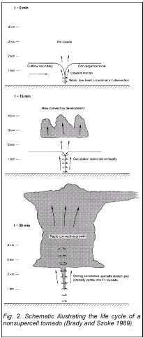 The figure above is a model of the formation of a non-supercell tornado, developed from a Doppler radar study of the DCVZ conducted by Szoke and Bradley in 1989. The importance of a boundary as a point of initiation was revealed in this, and subsequent, studies. It has been widely documented that non-supercell tornadoes can form in association with growth-stage cumulus clouds. These rapidly-developing cumulus clouds form along a convergence boundary such as the DCVZ, or an interaction between low-level wind flow and an outflow boundary. As illustrated at left, the convergence zone formation is the first phase in the development of clouds in the region. The elements of heat, moisture and convergence work together to form a circulation around a vertical axis. In approximately 15 minutes, the visible cumulus cloud forms in the rising vertical column of air above the vort point, and the vorticity is vertically advected and imposed on the rising air, (center frame). As the cloud develops pas the 30 minute mark, while still in growth stage, the vorticity is stretched as the air column rises rapidly. Air is pulled in at the base of the circulation to replace the rising air, enhancing development. In this manner, a non-supercell tornado forms, essentially from the ground, up. Or, more accurately, involving the entire column of air as it rises from the ground to the LCL and beyond. In addition, the position of the strongest convergence can have a profound effect on what type of severe weather develops, and its morphology. Convergence zones that form farther west, usually in more dry air, may only generate a few clouds as visible clues. When the zone forms farther east, in more abundant moisture and with more intense heating, stronger updrafts can be the result. Generally, storms forming on the DCVZ are slow-moving compared to those forming due to other situations. Most DCVZ storms sustain themselves in the same general area, rather than moving off onto the plains. When these storms do eventually get caught up in the mid-level flow, they sometimes lose intensity after moving off the convergence zone, because they no longer have a source of uplift. Unless such a storm can sustain its updraft in a favorable environment, it may dissipate. A favorable environment would be a region that has been experiencing strong diurnal heating and has had good moisture advected into it. Another key ingredient is shear. Unfortunately, most DCVZ days lack vertical shear due to the nature of the preexisting conditions that formed the DCVZ in the first place. A DCVZ will usually form on days of limited shear, especially in the PBL. The only shear that is generated is due to the deflected wind flow, rather than baroclinic conditions. All of the shear is at the lower-levels of the atmosphere, in the PBL. Mid and upper-level winds are usually weak on DCVZ days. DCVZ Chase Strategies  Non-supercell tornadoes can be fascinating to chase and photograph. The main advantage in viewing/chasing these tornadoes over mesocyclonic tornadoes is their slow movement. Supercell tornadoes can move as fast as 50 or 60 mph. Since DCVZ tornadoes form along a convergence boundary which sustains their growth and development, they tend to move at less than 25 mph and sometimes appear nearly stationary. In anticipating a DCVZ chase day, the synoptic and mesoscale features to look for include a stable southeasterly flow at the surface, strong diurnal heating, a capping inversion and low values of mid-level horizontal and vertical shear. Following frontal passage and the formation of a DCVZ, Al Pietrycha recommends an analysis of the persistence of the gyre. It should persist for at least 6 hours to be considered a true DCVZ. According to his research, the longest recorded DCVZ circulation was of a duration of about 36 hours. Surface data, satellite imagery and radar data are the three critical elements that should be utilized when in “chase mode” on a non-supercell tornado event along the DCVZ. According to Mr. Pietrycha and other veteran storm chasers, the key strategy in intercepting non-supercell DCVZ tornadoes is to locate on the DCVZ prior to the development of rapidly growing cumulus towers. Frequently, the time from initial cloud formation to tornadogenesis is less than 30 minutes. Surface data are essential for determining the location of the convergence boundary. Since temperature and humidity differences may be minimal, use the surface wind observations to determine the strongest area of convergence. Locating the boundary itself and the areas of strongest convergence can be difficult using only surface observations. This is due to the fact that there are very few “official” observation stations east of Denver, and they are widely scattered. Also, surface observations are only issued once per hour and mesoscale conditions can change much more rapidly than that. It is therefore necessary to supplement surface data with WSR-88D data. The National Weather Service office in Boulder, CO maintains a Doppler radar facility northeast of Denver, in perfect position for analysis of the DCVZ. As strong shear develops in the convergence zone, this will be evident in the colors displayed on the WSR-88D data. Storm-relative motion mode will reveal inbound winds as green and outbound winds as red. This will show the actual boundary, and eddies forming along it. These eddies can be a focal point for NSC tornadoes if a cumulus tower forms over them. High-resolution satellite data are also useful in locating the boundary and any cumulus clouds forming on it. The high-res images are updated every 15 minutes and will show towers going up along the convergence boundary. It should be noted that many DCVZ events generate non-supercell tornadoes in the early afternoon hours, between noon and 2 p.m. Therefore, shadows on the satellite images will be at a minimum. Careful analysis of satellite data on a large non-glossy display in low-glare conditions is usually necessary to pick up small cumulus clouds. Non-supercell tornadoes must be viewed from the west, looking east. The primary reason for this is their visual characteristics. Non-supercell tornadoes rarely reach above EF-1 intensity. Thus, they do not pull as much debris and dust from the surface up into their funnels. Additionally, there is no condensation funnel to speak of. This gives the tornadoes a semi-transparent appearance. If they are viewed looking west into brighter skies, they will be nearly invisible. However, looking east from behind the developing towers, the sun will not be an interference, and the dark color of the dust and dirt being sucked off the ground will contrast nicely with either blue sky or white clouds in the background. Forecasting tornadoes on the DCVZ is a continued challenge. There are no definite parameters on which to base forecasts, and no obvious patterns to the formation of storms along the boundary which produce non-supercell tornadoes. Conclusions With populations growing rapidly in the Denver area, continued research is necessary to better predict non-supercell tornadoes along the DCVZ. Non-supercell tornadoes can reach EF-1 intensity, causing substantial damage to homes and businesses. The rapid development of DCVZ tornadoes is a serious challenge to their prediction. The goal of NOAA is to be able to more accurately predict DCVZ tornadoes, while limiting the number of false alarms, which damage credibility and undermine the confidence of the public. I’ll propose a plan here that may aid in the research of conditions leading to non-supercell tornadoes on the DCVZ. With the development of GPS and mobile internet technology, it is now possible to coordinate a team of storm chasers positioned around developing cumulus towers on DCVZ days. My proposal would be to organize a volunteer group of chasers based in the Denver area who would be available to deploy on favorable days. In the chase vehicles would be a laptop computer with mobile internet. Interactive software can be developed to that the positions of the chase vehicles can be constantly monitored by a coordinator at NOAA in Boulder. The GR Level 3 radar program would be installed on each laptop in the chase vehicles. Also, NOAA could develop a standardized instrument package to measure wind speed and direction, temperature and humidity on each chase vehicle. This information would also be transmitted via mobile internet back to NOAA. In this way, a mobile mesonet of chasers could be positioned along the DCVZ to gather data, and then document any non-supercell tornadoes with video and digital photography. The key to accurately researching mesoscale events such as the DCVZ is to have a network of perhaps 50 mobile observation platforms, capable of delivering a large data sample for analysis. From this data, it may be possible to pinpoint enough parameters on which to base a tornado forecast on DCVZ days. The cost-benefit relationship is increasingly justifiable with the increases in population in areas frequently affected by the DCVZ. References Observations Of The DCVZ Using Mobile Mesonet Data. Albert E. Pietrycha and Erik N. Rasmussen. National Severe Storms Laboratory and Texas Tech University. Cooperative Institute for Mesoscale Meteorological Studies, NSSL and University of Oklahoma. The Denver Cyclone And Tornadoes 25 Years Later: The Continued Challenge Of Predicting Non-Supercell Tornadoes. Edward J. Szoke, NOAA Earth System Research Laboratory/Global Systems Division, Boulder Colorado in collaboration with the Cooperative Institute for Research in the Atmosphere (CIRA). Dave Barjenbruch, Robert Glancy and Robert Kleyla, NOAA National Weather Service Forecast Office, Boulder, Colorado. |