
The Ryukyu Island chain extends southwestward from Kyushu to Taiwan, forming the boundary between the Pacific Ocean and the East China Sea. Kadena AB is on the island of Okinawa, the largest of the Ryukyu islands and is located just to the south of the central ridge on the hills of Okinawa. There is a small plateau north- northwest of the base. The East China Sea is west of Kadena and the southwest runway approach is over water. The approach from the northeast is over four miles of small hills and farms. The Island of Okinawa is approximately 67 miles long and ranges from 2 to 17 miles wide. The northern two-thirds of the island consist of rugged hilly terrain. The average height of the hills is less than 1500 feet. The southern third of the island is less rugged, consisting of coral escarpments and small rolling hills. The terrain combined with the warm Kuroshio Current can cause enhancement of stable/unstable waves/precipitation as it moves towards or over the island. This is most evident when the Baiu Front sets up over the region. 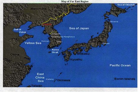 The northward movement of the Baiu Front begins in March and has its greatest effect on Kadena during the months of April-June. The front itself is nothing more than the separation of the tropical airmass to the south from the polar airmass to the north. The primary factors for movement of the boundary are the strength of the subtropical ridge and the upper level jet. If the jet is in a zonal pattern - the migration of the front will be slow and this leads to 6-8 day events of precipitation, low ceilings, visibility and overall poor aviation conditions. If the forecaster begins to see the stalemate setting up on the long range models (GFS, Japanese model GSM) - the focus will begin to shift to the mid levels and eventually down to the surface as the stratus challenge begins. Due to the location of Okinawa, satellite imagery is critical to picking up initial development of any waves that may form along the front. Water Vapor imagery is best suited to determine the location of the sub tropical ridge and the upper level jet stream. The forecaster will check the 500mb chart for any approaching short waves or vorticity maximums. However, if the setup is as mentioned in the previous paragraph…the forecaster will now try to identify and minor short wave troughs at 700mb, 850mb, 925mb and then look for any enhanced low level convergence on the 10m streamline analysis/forecast. Before we go any further into details - the images on the following page will help you visualize the front. Also, satellite imagery displays the typical weather setup during this event. To the north of the Baiu front is a 150-200 mile wide rain belt and an even larger belt of cloudiness while fair weather generally (not always the case but for the aircrew - this is where they want Kadena to be located) prevails to the south of the front. 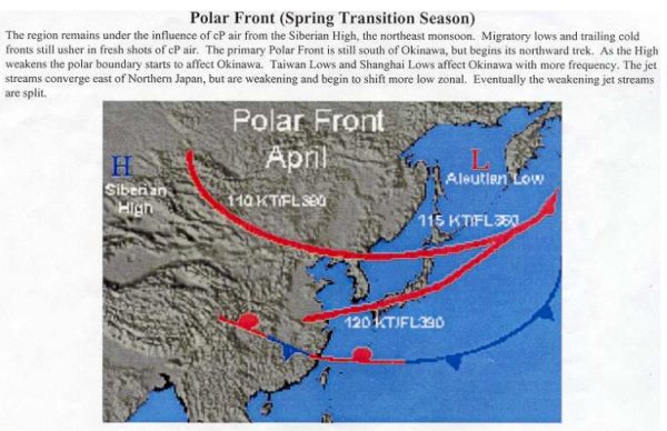 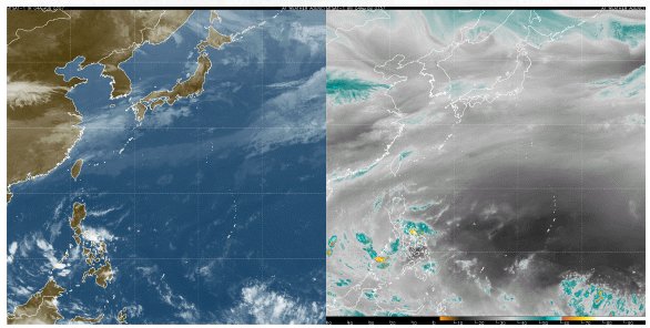 The Baiu rainy season is one of the main weather features on Okinawa. It signals the beginning of the transition from modified polar air to tropical air. It is our only true rainy season, accounting for about 30% to 40% of our annual rainfall. The Baiu generally migrates north at about 18 knots, although actual speed is dependent upon the strength and position of the sub-tropical high. If the high is stronger than normal, or shifts more to the north than usual, the Baiu season is shorter and could lead to a water shortage. As the front moves closer (less than 100 miles until it passes north), low ceilings, frontal fog, and heavy continuous rain will persist. Occasionally huge, persistent, and often stationary embedded thunderstorms form along the front. These thunderstorms are sustained by a combination of upper tropospheric divergence and lower tropospheric convergence from the summer monsoon. Although thunderstorms aren't good for anyone trying to fly - the main problem with the front is forecasting low stratus ceilings prior to passage. Once the winds are southerly ahead of a forming wave along the front, stratus prevails frequently. The onset of this usually occurs during the late afternoon throughout the night ahead of the approaching cold front associated the wave. As an aviation forecaster - timing is everything. If you can accurately pinpoint the time of occurrence - this will help determine what category pilot will be able to fly (as well as get you a beer at the club!). Although there are no real solid experts on this matter and I was not able to locate any studies by the Japanese - throughout the years, the Air Force forecasters stationed here at Kadena have developed some rules of thumbs which we are now in the process of verifying. The rules of thumb for spring stratus are listed below: 1. Apparently caused by cooling of moist southerly flow over cooler shallow waters. 2. Fog over water SSW lifts, advecting over the island's edge and prevails as stratus until dissipation 2 - 3 hours after sunrise. 3. Conditions of paragraph b above are intense when southerly flow is 10 - 20 knots, causing rapid cooling of the air and lowering the MCL (mixing condensation level). 4. Stratus is generally less than 1,000 feet thick, with bases at 500 to 1,000 feet. 5. With strong winds in the lower levels, stratus will form, SCT v BKN shortly after sunset; with winds SE through S, SCT over island but BRK on approach and to the east will be more prevalent. Stratus under these conditions usually is quite variable and burns off rapidly after sunrise, forming a SCT to BKN deck of stratocumulus based at 1,500 - 2,000 feet by 1000 L. 6. With light lower level winds, stratus generally stays SCT over the island until sunrise, becomes BKN for 2 - 4 hours thereafter, lifting from a low of 600 feet to 1,800 feet by 1100 L. In this case it is difficult to forecast the amount of cover and timing of ceiling periods, being generally independent of wind direction. 7. A good rule of thumb to follow on stratus forecasting: Surface to 2,000 foot winds greater than 10 knots. 0600 Z sounding showing 70% humidity or higher between surface and 2,000 feet. NOTE: (1) and (2) above will result in stratus ceiling of less than 1,000 feet by 1200 Z. The ceiling will be intermittent, both cover and height, and will remain until the surface temperature has risen 6°F from the minimum temperature. As I stated before, we are now verifying the rules of thumb and trying to find ways to improve the forecasts of this phenomena. One big hindrance now is the abolition of the only island rawinsonde by the Japanese Met Office at Naha airport (about 12 miles away). Although forecast models are continually expanding their abilities into forecast soundings, nothing beats real time data. If we had the same type of equipment available to us in this part of the world as in the United States, we could tackle this problem better. But for the time being, we will continue to use what tools are available to us - Satellite, models, local observations and any available tropospheric information - to verify, improve and possibly create new rules of thumb for Kadena Air base, Okinawa. |