
Tropical Cyclones also known as Hurricanes in the United States are one of the most destructive forces on the planet and also one of the most fascinating. They occur in various locations across the earth over warm oceanic waters. Their destructive power is usually a result of their strong winds, torrential rains, and storm surge. Within this essay we are going to take a closer look at these massive storms and their effects on the United States, particularly the state of Florida. This state is unique because it has two coasts with warm ocean waters on both sides, which makes the state liable to hurricanes from the west and east coast threatening both coastal and inland populations. Hurricanes form during the summer and early fall season (June-November) when oceans are their warmest. They are powerful storm systems comprised of numerous thunderstorms producing strong winds and flooding rains rotating counter-clockwise around a low-pressure center (clockwise in the southern hemisphere). These storms are fueled by the latent heat release of moist warm air rising causing water vapor to condense. These storms are warm cored systems similar to the extra-tropical mid-latitude cyclones found in the United States. They form within Maritime Tropical Air-masses and are brought to the US by the Trade Winds and the Coriolis force. These storms vary in size; they can be as small as 5 kilometers in diameter to 2170 kilometers, as achieved by Hurricane Tip in October of 1979, which is the largest hurricane on record (List of Tropical Cyclones, Wikipedia). The main atmospheric processes, which create these storms, results from an easterly wave (in this case off the west coast of Africa) and the release of latent heat from water condensing at high altitudes. With solar heating being the cause of evaporation, these storms become fueled by massive energy equated to multiple Nuclear weapons. These unique Mesoscale Convective Complexes develop over a large area of moisture and warmth. Condensation from the latent heat results in higher wind speeds, as a small portion of the released energy is converted into mechanical energy. These faster winds associated with low-pressure increases surface evaporation, thus creating more condensation. The majority of this released energy causes very strong updrafts, which increases the height of the storm clouds, speeding up condensation. This "positive feedback loop" continues for as long as conditions are favorable for hurricane development. This loop is the recipe for producing the hurricanes Eye and Eye-walls where the strongest winds are. The Coriolis effect of the earth causes this system to spin, giving the hurricane the cyclonic effect and plays a roll in its trajectory. (Hurricanes Development, Wikipedia) 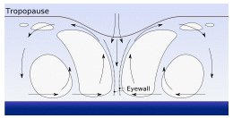 **Tropical cyclones form when the energy released by the condensation of moisture in rising air causes a positive feedback loop over warm ocean waters. ** These storm systems are also known to have deep convection as a result of forming in Tropical climates where convection is the greatest. In order to keep the hurricane's heat engine running, the storm requires the warmth of the ocean. When these storms are no longer over water the "positive feedback loop" is affected and the storm weakens significantly. This is one of the reasons why hurricanes are so dangerous to islands. These landmasses are small compared to the size of hurricanes. Since the majority of the storm is still over water the storm is usually not affected and the full force of the hurricane is felt. These storms although having a season of occurrence are usually sporadic. The year of 2004 was a very busy hurricane season. Four tropical systems (Jeanne, Ivan, Frances and Charley) hit the state of Florida (The Atmosphere P.322). Although it was unusual for so many hurricanes to hit Florida collectively, it was not unusual for so many to form. Florida's location causes these storms to attack from both sides. Florida is a peninsula located on the southern coast of the United States. Unfortunately this state is in the direct pathway of many Hurricanes, which form in the Atlantic Ocean or travel through the warm waters of the Gulf of Mexico. This makes Florida susceptible to these storms because it is surrounded on either side by warm ocean currents. This was made evident as Charley made landfall in Florida from the states west side while Francis and Jeanne made landfall on the states eastside. Since these storms can make landfall on either side of the state, this can pose a slight forecasting problem for Meteorologists. Since these storms are so unpredictable figuring out there trajectory can be difficult. Forecasters also need to take into account Sea Surface Temperature and Windshear, which help negate hurricane intensity (Vasquez, 154). Usually depending on your forecast thousands of people make the decision to evacuate or remain. Hurricane landfall has its variations. Coastal landfall is the most severe as a result of storm surge. The ocean can be one of the most destructive forces on the planet and hurricanes tend to manipulate that power. The high winds of the storm cause oceanic waves to reach as high as 20 feet causing dangerous flooding, which was the case with hurricane Katrina that affected New Orleans horrendously. These storms are also the strongest when they first make landfall. The highest winds of a hurricane are felt on the coast as the storm comes ashore. With all this being said the coastal regions are normally the areas taking a keen interest in the forecast of meteorologist regarding the decision to evacuate. This is the main forecasting challenge. Once hurricanes are onshore they start to weaken drastically. This doesn't mean that they are no longer a threat, their winds are still dangerous averaging around 70mph or greater. Onshore hurricanes pose another forecasting problem: Tornadoes. Hurricane Frances alone produced up to 102 Tornadoes during its landfall onslaught across the southeastern United States. Flooding also remains an issue for hurricanes over land. These storms produce so much torrential rain that they can cause flash flooding in various locations. Provisions are being made to forecast these storms with better accuracy. More weather buoys are being released in the ocean in addition to the forecasting tools available now. If these storms are located before they form more analysis can be done negating in the validity of the forecast. To conclude, Hurricanes are one of the most destructive storms known to man. These storms form in the warm oceanic waters of the northern and southern hemispheres, which varies depending on location. The hurricane season for the southeastern United States is June-November. During this time frame many hurricanes are possible and are brought to the US by the trade winds and other circulation mechanisms. Florida is usually the state most affected by these storms because of its unique location. Florida is a peninsula with warm ocean currents on either side, which allows hurricanes to make land fall on either side of the state. Florida also receives variations of coastal and inland effects from hurricanes. By comparison coastal landfall is usually more severe and results in the evacuation of the effected public. These occurrences make forecasting for hurricanes a great responsibility and quite difficult for meteorologist is this region of the country. Bibliography Lutgens, Frederick K, and Edward J. Tarbuck. The Atmosphere 10 Edition New Jersey: Pearson 2007 Vasquez, Tim. The Weather Forecasting Handbook Garland,TX: 2002 Wikipedia. "List of Tropical Cyclones" March 2007 URL: http://en.wikipedia.org/wiki/List_of_tropical_cyclones Wikipedia. "Tropical Cyclone" November 17, 2003 URL: http://en.wikipedia.org/wiki/Tropical_cyclone |