
Introduction: The Colorado Low is an area of lower pressure that develops in the vicinity of Colorado on the eastern side of the Rocky Mountains. The Colorado Low is the third most frequent synoptic system that influences the United States, trailing only the Alberta and North Pacific Lows. This storm system generally wreaks havoc on forecasters as it can bring an array of weather features and forecast challenges throughout the Southern Plains and the Upper Midwest before moving into the New England States. From heavy snow and torrential rains, to supercell family outbreaks and strong winds, this storm system has it all. 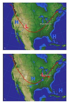 Generally, the Colorado Low is a re-development of a previous system that entered the west coast. Whether North Pacific or South Pacific Lows, these systems will typically dissipate as they move into and over the Rocky Mountains where rugged terrain in the mountains increases the friction leading to dissipation. The Bermuda High will allow for southerly flow to pump an influx of Gulf moisture into the southern plain states. This inflow of warm, moist gulf air aids in airmass destabilization, resulting in the cyclogenesis of the Colorado Low. Don't be fooled by the name of this system; this low doesn't necessarily have to develop in the state of Colorado. Many cases have shown that this system can form in the Texas and Oklahoma Panhandles and possibly western Kansas. A precursor of the development of this low will be a trough that develops on the lee side of the Rocky Mountains. The most typical track of the Colorado low is from western Kansas off to the Northeast towards the Great Lakes and southeastern Canada. In winter and early spring, occasionally the jet stream will dig deep into the Rockies and southern plains, allowing the system to push further south into Texas and Louisiana. In this case, the system will cause widespread showers and thunderstorms throughout the south, and heavy snowfall on the backside of the low, if conditions are right. To add to the difficulty in forecasting these systems, strong gradient winds are extremely common both ahead of and behind the associated cold front. SEVERE WEATHER The four primary ingredients for severe thunderstorms are: instability, wind shear, dynamic lifting and an abundance of moisture. All of this criterion will generally be found in Northern Texas and Oklahoma in a classic Colorado Low set-up. Southerly flow ahead of the approaching cold front will allow for moisture advection from the Gulf of Mexico. Typically, a strong low level jet will form about 1,000 feet above ground level during the nocturnal hours as an inversion sets up. The velocities of this low level jet can vary from 25 knots to higher than 50 knots on some occasions. Graphical model forecasts will often under estimate the strength of these winds; verification will need to be completed by viewing observed soundings and VAD wind profiles on radar. As daytime heating occurs, the surface temperature will increase enough to break the inversion allowing for these winds to mix down to the surface. Gusting southerly flow will interact with the cold front causing an area of convergence that will enable thunderstorms to form, and adding rotation in the lower levels of the atmosphere. With the low levels in prime condition for severe weather possibility, the mid levels of the troposphere must also meet certain criteria to enhance severe thunderstorm activity. Mid-level winds between 700 and 400 millibars will flow from west to east across the Rocky Mountains. As these winds blow perpendicular to the mountain chain, they will begin to descend the peaks in eastern Colorado. As these winds continue their descent, adiabatic warming will add a column of dry air to the parcel. This dry air will entrain into the downdraft, promoting evaporative cooling which will enhance the negative buoyancy of the parcel. Furthermore, the general westerly flow will increase the wind shear from the surface up through the mid levels. This veering in the winds is highly indicative of the potential for supercell and tornado formation. Look at observed soundings and pilot reports to justify the direction of the mid level winds as these are necessary for rotating thunderstorms. One of the most important factors in severe thunderstorm forecasting is the dynamics that take place at and above 700mb. The best case scenario for severe thunderstorm potential will be a negatively tilted trough in the jet stream. This occurs when a strong jet max moves through the base of the long wave trough, causing deepening of the low. As these stronger winds move along the southern edge of the low, the trough position will begin to tilt in a northwest to southeast orientation. Be aware of the location of the right rear and left front quadrants of the jet stream. These locations provide favorable areas of divergence and enhance uplift. View a looping water vapor image to help locate the polar front jet. The most important key is that the jet max will provide tilt within the column, which displaces the updraft from the down draft. Often graphical models will differentiate from one another on the amount of vorticity advection into an area. Recent model developments have come out with ensemble forecasts. This is a good tool to use for 500mb heights and vorticity. The ensemble model is a combination of different models that will provide a single output that can be used. It's basically a blend of all models. Forecasting the severity of thunderstorms can be a difficult task. Knowing the situations and analyzing the proper charts will assist you in forecasting. When the above conditions are met, the likely worst case scenario exists for Kansas, Oklahoma and Texas, also known as Tornado Alley. A strong continental polar airmass, sometimes arctic, will force these lows into northern Texas before moving off into the Mississippi Valley. The colder air from the north will clash with moist subtropical air in the south, causing an outbreak of destructive thunderstorms. Generally, severe thunderstorm activity tends to subside with the loss of daytime heating; however, if these conditions exist throughout the night, view 00Z soundings to compare the actual conditions to that of what the models are forecasting. WINTRY WEATHER A Colorado Low that forms in winter and early spring will almost always have precipitation in the form of snow, sleet or freezing rain that accompanies it. The conditions necessary for winter precipitation isn't nearly as complex as of that needed for severe thunderstorms. Only two elements are needed for wintry weather: cold air and available moisture. Keep in mind that temperatures that are too cold will not retain as much moisture as of those just below freezing. A good indication of heavy snowfall potential is if the 700mb dew points at warmer that -10 to -5 degrees Celsius. Generally, Colorado Low's will be one of the major snow producing mid-latitude cyclones. Frequently in the winter, an area of high pressure will move into the upper mid west from Alberta Canada, known as the Alberta High. This is one of the most common high pressure systems that affect the central plains during the winter. Cold air advection will spill down the eastern side of the Rocky Mountains causing a cold wave that will persist usually for 24-72 hours. If a Colorado Low were to develop during this situation, one of the key ingredients (cold air) for winter weather is already in place. As the low continues to develop, southerly flow will advect moisture into it from the Gulf of Mexico. The typical frontal situation will be a warm front through Kansas and Missouri with the trailing cold front in western Texas. Warm, moist air will spill over the warm front allowing for overrunning conditions to exist. Analysis will be needed to determine the depth of the warm layer above the surface to decide whether precipitation will fall as rain, sleet or snow. Generally light snow will exist along and ahead of the warm front as it moves off to the Northeastern states. The main concern will be the potential for heavy snowfall. The heaviest snow is often a narrow band that is usually 50-200 miles to the left of the cyclone track. If the upper level low were to be cut off from the jet stream, this region of heavy snow can last for several hours, producing significant accumulations that will hamper air and ground travel. White-out conditions have been known to occur when this situation is in place. A forecasting problem will exist if the models do not pick up on the low becoming cut off from the jet stream. FLOODING As Colorado Low's move off to the Northeastern states, an area of higher pressure will move in behind it. During late winter and the beginning of spring, these systems will become more frequent as warmer air attempts to replace the colder air masses. As this occurs, a rapid fluctuation in surface temperature will coincide. Snowfall with previous systems will be melted by rain in the months of February through April which can lead to devastating floods throughout the Mississippi Valley eastward into the Ohio Valley. The ground will become saturated leading to runoff into nearby streams and rivers. After enough run off is obtained, the rivers will exceed the maximum holding capacity and water will advance out of the river banks. The general flow of the rivers in this region will be to the south and west. Waters will flow into flood prone regions from Missouri southward into Mississippi. GRADIENT WINDS During the cyclogenesis stage of the Colorado Low, a pressure difference between High's and Low's will be created due to a difference in air density. In attempt for the atmosphere to attain equilibrium, an increase in pressure gradient force is achieved. Strong southerly winds ahead of Colorado Low's from Texas through Kansas can be a forecast problem. A rapid deepening of the low can make this very problematic. In this case, graphical forecast models may have a tough handle on how tight the gradient actually is. Hourly analysis of surface weather observations may be needed to verify the accuracy of the model forecasts. The strongest gradient winds with a Colorado Low will typically occur after frontal passage as cold air advects into the central plains. A study completed by Altus Air Force Base in Oklahoma indicated that by analyzing the pressure differences between Dodge City, Kansas and Dyess Air Force Base, Texas, a forecaster can accurately forecast the maximum wind gust potential. Over a 2 year span, if the pressure gradient between these locations was 6.7mb, then wind gusts to 25 knots could be expected. This occurred on 475 occasions during this study. It also showed that when the gradient was 9.4mb or greater, then 35 knots or more was likely. This showed an occurrence of 78 times during this time frame. The Colorado Low can be one of the most powerful mid latitude cyclones during the winter months for North America. Fortunately, these cyclones are very frequent which can give forecasters many occasions to experience the different weather effects for a specific place. Contemporary model forecasting seems to be accurate, but it has shown that further analysis will be required to initialize and verify the integrity of the information output. The most difficult challenge for forecasters could be the timing and duration of snowfall. Forecasters need to know their station's proximity to a water source, topography, and other local effects that may enhance the prediction process. References: Altus Air Force Base wind study: https://ows.barksdale.af.mil/ows_unique/26/tech_ref/TFRN/html/ltshtml/ LTS_Fcst_ROT/LTSWindStudy.htm |