
"You do the weather in Palm Springs? That must be easy, hot and sunny everyday!" If I had a dollar for every time I heard that, I would be retired by now. With the name Palm Springs images of sunny skies, beautiful mountains, and swaying palm trees probably come to mind. After all, there are more than 120 golf courses in the area, so the weather must have a little something to do with that. Despite the Albert Hammond song "It Never Rains in Southern California," it really does. When that wet weather comes in, it can be a big forecasting challenge in Palm Springs. This is an area that is a classic rain shadow climate. To set the stage, you have to get a lay of the land. While Palm Springs is probably the most well known, there are 9 cities that make up the Coachella Valley. The valley lies east of Los Angeles and San Diego, where the Southern California Mediterranean climate turns into a mid-latitude desert. One of the main reasons the Coachella Valley is a desert climate, can be credited to the tall mountain ranges that surround it. To the west-southwest are the San Jacinto and Santa Rosa Mountains. To the north-northwest lie the San Bernardino and Little San Bernardino Mountains. The valley's elevation is right around sea level. Palm Springs sits around 400 feet, while the eastern end of the valley near the Salton Sea is about 200 feet below sea level. The highest peaks include Mount San Jacinto, towering 10,834 feet above the valley floor. The highest peak in the San Bernardino range is Mount San Gorgonio standing at 11,502 feet (Wikipedia). 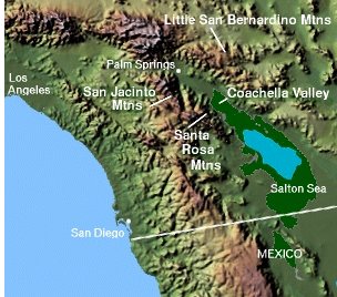 These mountains not only add to the desert's beauty, but are a major factor when forecasting precipitation for this area. When storm systems move through Southern California, the mountains act as a barrier for the rain to get over. Many times it can be raining just 20 miles to the west, while the sun is shining over the Coachella Valley. It's interesting that Palm Springs averages 5.23 inches of rain a year, while areas just west of the mountains see on the order of 10 to 15 inches a year. The picture below is a classic example of a system moving through the area. Rain is falling through areas west, clouds are hanging over the mountains, and the valley is experiencing sunshine. 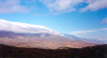 The reason this happens, is because the mountains provide orographic lifting. When moisture laden air comes off the Pacific Ocean, it hits the mountains and is forced to rise. As the air ascends the mountains it cools, condenses, and forms rain over the windward slopes of the range. In addition, the mountain's irregular topography can also provide differential heating, leading to localized enhanced convection (Lutgens & Tarbuck 111). After most of the moisture is essentially wrung out over the mountains, the air descends down the other side of the range. During descent the air compresses, warms, and dries out. This provides the rain shadow for areas on the leeward side of the mountains like the Coachella Valley. 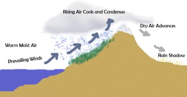 This forecasting problem is seen mostly during the rainy season in Southern California, which runs approximately from November through April. This is when the jet stream heads further south and more storm systems take aim on the area. Forecasting how much or how little rain will make it over the mountains presents a challenge. The biggest reason, which I'm sure is no surprise, is that computer models do not do a good job with a mesoscale process like this one. Many times it will be showing precipitation and none will fall. Other times it will show all the rain staying out of the area and some will make it over the mountains. Models have a hard time grasping where the moisture bands are going to set up. While blaming the computer models is always an easy target, there are some techniques to help you determine if you'll need your umbrella in the desert. Speaking with Ed Clark, Warning Coordination Meteorologist for the National Weather Service in San Diego, there are many things his office looks at when forecasting precipitation events for the Coachella Valley. First and foremost is looking at the deep level moisture. It has to be several thousand feet thick to make it over the mountains and have a chance at precipitating over the desert. A deep marine layer is not good enough. When moisture is in place, you also need lift. Many times a surface mid-latitude cyclone without a lot of upper level support will have a hard time bringing the moisture over. "You need moisture associated with an upper level low, especially a deep and/or dynamic one," says Clark. "Something strong enough to help carry the moisture and dynamics over the mountains, so that it doesn't end up on the San Diego side and peter out." Another important thing to analyze is the direction of the moisture and low pressure system. Looking at the diagram of the Coachella Valley at the top of the paper, you will notice the valley opens up toward the south-southeast. After passing the Salton Sea there is the Imperial Valley, Baja California, and eventually the Gulf of California. This open passageway is one way the moisture can make it into the desert without having to interact with the topography of the mountains. "If moisture is wrapped around the low and comes up from Baja, on the east side of the system you are much more likely to get significant precipitation," says Clark. This has certainly been my experience when forecasting for the valley. A perfect setup for a desert soaking is a good feed of subtropical moisture out of the south and an upper level low to interact with it. Also, you never want to underestimate the power of an upper level low. I know we have already mentioned the models, but it is worth reiterating. Models do not handle upper level lows well! I have had a forecast or two busted by an upper level low taking a different track than the models predicted. The variation of a couple hundred miles in the low's track can mean the difference between a wet or dry day. Speaking of the upper level low family, you have to mention the infamous cutoff low. A cutoff low is not connected to the jet stream. Without the aid of the upper level winds, these lows can be very unpredictable to forecast. In fact, I have heard them referred to as "the weatherman's worst nightmare." That may be a bit overdramatic, but they are worth keeping a close eye on. These lows can slowly migrate down the Southern California coast, picking up moisture before making their turn inland. When you see one approaching the area, nowcasting is the key. If you see it intensifying on satellite and radar imagery, look out, this can bring precipitation to the desert very quickly. The rain shadow effect can also be seen outside the typical Southern California rainy season. Between July and early September the summer monsoon rages over the desert southwest. The monsoon is a seasonal reversal of the winds. Instead of the westerly flow we experiences most of the year, a southerly flow develops. This pumps subtropical moisture into the desert southwest. With the afternoon heating, a thermal low develops over the desert and convection occurs. This provides widespread thunderstorms over the region. Here in the Coachella Valley we are on the western fringe of the moisture feed. We do not see nearly the activity Arizona and New Mexico experience to our east. However, we do encounter convection in the area and the mountains are a big reason for this. Similar to when a mid-latitude cyclone comes in during the rainy season, most of the precipitation during the summer monsoon gets hung up over the mountains. The higher terrain provides more lift than the valley floor, making thunderstorm formation more common over the mountains than the surrounding desert. When forecasting for this area during the summer monsoon, it's important to look at sounding data. Unfortunately there is not a radiosonde balloon launch in the valley. The closest launch points are in San Diego and Yuma, Arizona. Even though it's roughly 150 miles away, the Yuma sounding is your best bet during the summertime. On the sounding you can get an idea of how high the PW values and instability indices are for the day. Although it's simple, taking a look outside in the morning can tell you how the day is shaping up as well. If you start seeing cumulus developing over the mountains around 10 am, you know it's going to be an active afternoon. Nowcasting is also extremely important during the monsoon. Keeping an eye on the satellite and radar imagery is imperative. Even though most of the development is over the mountains, outflow boundaries and gust fronts can spark convection over the valley floor. Keeping these techniques in mind can help you forecast around the unique topography of the Coachella Valley. Giving an accurate forecast is what we all strive for. Looking at how the event is setting up and keeping a close eye on how it's shaping up, you can give the public the information they need to know when they're not outside enjoying the desert sunshine. References Clark, Ed. Warning Coordination Meteorologist. National Weather Service San Diego, CA Lutgens, Frederick & Tarbuck, Edward (2004). The Atmosphere Ninth Edition. Upper Saddle River, NJ: Prentice Hall Image: Coachella Valley. http://en.wikipedia.org/wiki/Coachella_Valley Image: Rain shadow. http://en.wikipedia.org/wiki/Rain_shadow Image: Rain shadow picture. Miguel Miller. Meteorologist. National Weather Service San Diego, CA. San Jacinto Peak. http://en.wikipedia.org/wiki/San_Jacinto_Peak San Gorgonio Mountain. http://en.wikipedia.org/wiki/San_Gorgonio_Mountain |