
On January 9, 2008, 70 cars and trucks piled up in a chain-reaction collision on Interstate 4 between Tampa and Orlando. Four people were killed, 38 injured. On March 13, 2007, a log truck on the Florida Turnpike plowed into emergency vehicles responding to a crash. More vehicles slammed into the wreckage. Five were killed. On May 26, 2006 on State Road 528 near Orlando, 26 vehicles smashed into one another when visibility suddenly went to zero. One person was killed, four injured. The common element in these deadly crashes, and many others, is smoke-fog, an impenetrable combination of fog and smoke that forms in minutes. It forms so quickly, authorities typically cannot close roadways until it is too late. Smoke-fog is a common phenomenon in Central Florida and much of the southeastern United States. Also called superfog and fog-smoke, it occurs when smoke from wildland fires builds up overnight, and combines with morning radiation fog. Smoke-fog may be the area's number one weather killer. Its death toll exceeds that of hurricanes and lightning in Central Florida, and is comparable to that of tornadoes. Yet many forecasters and many law enforcement agencies and highway departments treat it with far less urgency than severe weather. The National Weather Service office in Melbourne issues advisories for dense fog, including smoke-fog, but no warnings. The purpose of this paper is to identify the conditions under which smoke-fog develops; to describe its properties; and to show that smoke-fog should be given the same attention as severe weather. Atmospheric Setup Smoke-fog occurs most often during Central Florida's cool season, when nights are long, mid-level air is dry, high pressure resides for extended periods, and rain is relatively rare. During this season, especially from March to May, but starting as early as January, wildfires are common. Radiation fog often develops overnight during the cool season. Cloudless nights with little or no wind result in radiational cooling of the surface and the air closest to it. An inversion forms about 200-400 feet above ground level. When the surface air cools to the dewpoint, water vapor condenses into droplets, and fog forms. Typically, the fog is light, with visibilities greater than a quarter-mile and often greater than a half-mile. Under these same conditions - high pressure, light wind and long nights - smoke from wildfires or controlled burns is trapped near the surface under the inversion. Overnight, wildfires typically "lay down:" they burn much less actively and smolder for hours. Wildfires that have been put out continue to produce smoke - sometimes for days. This buildup of smoke under the inversion is relatively light, with visibilities greater than a mile. Properties of Smoke-Fog The combination of light smoke and light fog forms a thick, opaque vapor that is, in the words of National Weather Service Warning Coordination Meteorologist Dennis Decker, "greater than the sum of its parts." Visibility is zero; a few feet at most. Drivers cannot see beyond the hood of their vehicles, and in some cases cannot see the front of the hood. In a research paper for the United States Forest Service (http://www.srs.fs.fed.us/pubs/6971), author Gary L. Achtemeier reports superfog -- produced by burning hay bales during foggy conditions -- was so thick, rangers driving on a forest road could not see the trees lining the roadway, and drove off the road. Smoke consists of tiny particles of ash and carbon, which provide superabundant condensation nuclei for water droplets. Achtemeier writes that smoke provides chemical constituents available for reactions with water vapor. The additional condensation nuclei may result in additional water droplets - a much thicker fog, with smoke mixed in. But the most insidious property of smoke-fog is the rapidity with which it forms. "Out of the blue, visibility shuts down. In minutes," according to Florida Division of Forestry District Supervisor Ron Weis, who has many years' experience fighting wildfires. Law enforcement officers, waiting for the fog to "move in" before they close roads, don't have a chance. When the air cools to its dewpoint, the smoke-fog forms all around, from the available water vapor, in a very short time. A backyard demonstration produced smoke-fog in seconds. A small glass enclosure was used, with ice to cool the air in the enclosure. When smoke was added, no change was noticed in the thickness of the smoke. When the smoke was removed and water vapor was added, condensation may have occurred, but in such a small enclosure, water droplets were too few to be visible; nothing was seen. But when smoke and water vapor together were added to the enclosure, a thick vapor formed immediately. The vapor formed a layer at the top of the enclosure, because the smoke, or condensation nuclei, rose to the top. The demonstration was not scientific because the amounts of water vapor and smoke were not controlled or measured. But it suggests the same thing as many eyewitness accounts: smoke-fog forms quickly. 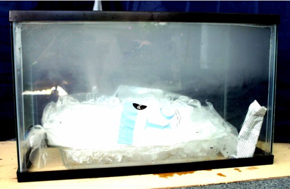 Forecasting Smoke-Fog To forecast smoke-fog, a forecaster should look for the atmospheric setup described above: a small dewpoint depression at the surface, overnight clear skies, light wind. The level of the inversion is also a factor; 200-400 feet is common for fog formation. If the temperature falls to the dewpoint, fog will form. In addition, the forecaster must be aware of the location of fires and the direction in which smoke will drift. The state of Florida identifies the locations of fires on a web page; many other sources of this information are available, including news reports. Where smoke and fog are together, especially in the area of a major highway, a smoke-fog warning should be issued. The National Weather Service office in Melbourne has considered elevating the status of smoke-fog advisories to warnings. Warning Coordination Meteorologist Decker told this writer more research is needed. He said the precise constituents of smoke-fog and the conditions for its formation are not well known. Achtemeier, in the forest service paper cited above, noted that superfog failed to form on a second consecutive night when the same atmospheric setup prevailed and the experiment was repeated. The NWS issues dense fog advisories whenever visibility is expected to fall below a quarter-mile; those advisories include the presence of smoke-fog. A researcher at the National Center for Atmospheric Research has suggested smoke-fog can be artificially dissipated using hygroscopic flares. The flares produce a set of nuclei for raindrops that are biased toward large drops, causing coalescence and rain. "Flares could be lit near the roadway... to intiate larger droplets... that would coalesce and DECREASE the optical thickness of the fog," writes NCAR's Richard Wagoner (http://knowledge.fhwa.dot.gov/cops/hcx.nsf/). Conclusion We cannot perfectly predict tornadoes; we cannot perfectly predict severe thunderstorms; we cannot perfectly predict fog. Smoke-fog is as different from fog as severe thunderstorms are from light stratiform rain. Part of better smoke-fog forecasting is education and warning. Forecasters must redouble efforts to educate the public and public agencies; public education is a duty of all forecasters. Highway managers must be made to understand smoke-fog does not "move in." It forms all at once, all around, out of "thin air." More research should be done. The public will be safer if smoke-fog is treated with the same importance as the other weather killers. Smoke-fog should be elevated to the same status as severe thunderstorms and tornadoes, and official National Weather Service warnings should be issued when smoke-fog is expected within one to two hours. |