
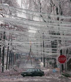
 Winter time in western Pennsylvania always poses a problem for drivers and meteorologist alike. Western Pennsylvania in the winter has been known for grey skies and snow, most of the time. This last winter was a different story for Western Pennsylvania, where a mixture of snow, sleet, and freezing rain occurred, that gave most meteorologists in the area gray hair. This freezing rain even is caused by the location of Pittsburgh, Pennsylvania in the general weather patterns. The contributor to Western Pennsylvania's freezing rain problem is the location of this region. Western Pennsylvania fills a void between the warmer tropic jet to the south and the polar jet to the north. During the winter time the Polar jet and the subtropical jet battle for supremacy in this region. This battle can cause a huge ripple in the flow pattern which is known as meridional flow and can keep this region flirting between freezing and unfreezing temperatures. This temperature extreme helps promote freezing rain when a cooler air mass moves into the area. This colder air mass will force the warmer air mass above it and set up a perfect atmosphere setting for freezing rain to occur. Also the great lakes as their role as the giant heat engine encourages any low pressure systems to travel up the Ohio valley and set in over the lakes. This ensures that western Pennsylvania will get its share of mid latitude cyclones during the winter time. The main problems for predicting freezing rain in this area would be topography. Western Pennsylvania is compiled of hills and different elevations which can cause headaches for freezing rain predictions. One location may be perfectly suited for freezing rain to occur and the just ten minutes north they could be receiving snow. This happens due to the warm layer the snow has to travel though. One location may experience enough warmer weather to have perfect warm layer to melt the snow into a water droplet while other areas may not have that thick of the warm layer. Freezing rain events were not so uncommon to the area, but last year they occurred about twelve times during the winter season. This is significant for the public, due to the school closings and others trying to get to work. Another effect this has is on the road crews who didn't anticipate this type of precipitation to occur. Meteorologist in this area try their hardest to get this prediction correct, but always have to face hurdles. The best aid a meteorologist in this area could have is upper level data. However, upper air data is only done twice a day and in limited locations, so it forces the forecaster to rely on radar data. Radar data also doesn't help the forecast in this situation because it can't predict the form of precipitation, but just show it. The forecaster has to rely on model data, and upper level flows to make their best guess on if freezing rain will occur. Before freezing rain forecast will get more predictable a new type of weather forecasting tool would need to be developed. It would be a type of radar equipment that could provide the forecaster with constant upper air data, such as temperature, humidity and wind speeds. This data would be the most useful for freezing rain prediction in our area. Until some form of prediction that fits these qualifications is developed, forecasters will still have to rely on what they have been using. This last winter in Western Pennsylvania was hammered by a series of freezing rain events. It caused most of our residents to stay indoors, and also caused a lot of accidents around our region. When people hear about freezing rain they stay inside and wait it out, but what can we really do about preventing freezing rain. In the larger picture we cannot change weather patterns significantly to stop the production of freezing rain, but we might be able to inhibit the effects it has on our lives. An idea that presents itself to prevent freezing rain would be for our transportation department to modify the way they handle this event. The common practice is for Penn DOT to salt the roads and hope for the best. Salting the roads can help after the weather system has passed to clear the roads, but does little in preventing freezing rain. They would be more effective if they used a liquid form of a salt. This would help the freezing rain to mix with this other liquid form and try to halt the freezing process. Also this product could be warmed before being applied to the surface of the ground to halt the one process of freezing rain. Rain would no longer be able to freeze on a super cooled surface and would flow as a normal rain. This idea could prevent a freezing rain even for our roadways in this region. Freezing rain is not uncommon during the winter time in western Pennsylvania. However this last winter tended to promote more freezing rain that this region has seen in a while. Forecasters are attempting to provide adequate forecast, but have problems due to the topography of this region. The main forecaster tool used for this prediction is upper air data, but only taken twice a day and not performed everywhere. New technology could help the prediction of freezing rain, but is still years away from being developed. Freezing rain cannot be stopped, but different approached can be taken to prevent it. Salt is the primary option for prevention, but has limited effects on actually preventing it. A liquid form of prevention could be more effective to prevent a totally freeze up of the roads by inhibiting the main causes of why freezing rain occur. We cannot change the weather patterns or even eliminate freezing rain forever, but we can change the way we view and prevent this phenomenon from effective our lives. Works Cited Weather Sense. 15 May 2005. 22 March 2008 http://www.pilotsweb.com/wx/w_sense.htm |