
1. Introduction Over the last few years a tremendous amount of research has been focused on mesocyclonic tornadogenisis. Focusing on many parameters, which have followed a standard for many broadcast and operational meteorologists. The terms land spout, waterspout and gustnados seem to have fallen into a category of non-supercell tornadoes (Caruso, Davies 1). However, it is also very important to keep in mind that the general public does not define a difference between land spout, waterspout or gustnado. The vast majority of the general public strongly believes that, “If it is spinning and debris is visible, it’s a Tornado!” Keeping this in mind, this paper is for the purpose of increasing the awareness of tornados that can occur in a non-mesocyclonic environment for future broadcast and operation meteorologists. When these types of tornados occur, many meteorologists have been caught by surprise and have to quickly find reasons that tornado watches or warnings were never issued. This paper is designed to increase awareness of the future broadcast and operation meteorologist of this type of weather event. Items covered below will include the geographical locations including an area of focus, the parameters that will need to be closely watched, how to apply the parameters into ones forecast, the negative impacts if a meteorologist chooses to ignore those parameters and finally a solution and the benefits from increasing ones awareness of the non-mesocyclonic tornado. 2. Geographical Location What geographical location are “non-mesocyclonic tornados” found? Different research and observations have placed these events from parts of South Dakota, south to central Texas, but for the purpose of this paper the area of focus will be contained to south central Kansas including the City of Wellington. This area is located within the region termed “Tornado Alley”. It should also be noted that the majority of these events coincide with timing of tornado season in the central plains, that being at anytime, but not limited to, between the months of April through June for the State of Kansas (NSSL 1). This paper will examine an event that occurred outside the normal “peak season” in south central Kansas. 3. Parameters After examining several case studies there appears to be a few common ingredients in the atmospheric environment to be favorable for formation of a non-mesocyclonic tornado. According to research by meteorologist Jon Davies (Davies 2), a forecaster should be aware of the following parameters: A stationary front or a very slow moving boundary with a very small temperature gradient, or even a wind shift boundary. A surface heat axis intersecting the boundary, A deep moisture sounding, Low surface based CAPE below 3000m but, just above the LCL Higher that expected LCL, above 2000m, followed very closely by a LFC elevation Steep lapse rates in the lower 2 to 3km And very small CIN readings Some of the above parameters are displayed on the skew-t chart (Figure 1). If one does not look for the above parameters, it would be easy to only see a “loaded gun” sounding and unknowingly ignore other parts of the sounding. It should also be noted that research has shown that an area of overlapping of steep low level lapse rates >7 C/km-1 and 0-3 km MLCAPE. > 30 J/KG-1, in Figure 2, should not be ignored. In addition to the above parameters it appears that these non-mesocyclonic tornados can form in the early updraft stage of a larger mesocyclonic storms life cycle as indicated in the radar image shown in Figure 3. It is interesting, as if one examines closely in Figure 3, a small southbound outflow boundary moving into the area of overlapping steep lapse rate and 0-3km MLCAPE. This “boundary” appeared to be the focus of sudden increased vorticity. It did produce tornado that caused F2 damage south of Wellington, Kansas. (CRH-1) Observers of the tornado commented that it formed on the ground first and then ascended into the high cloud base with a full condensation as shown in Figure 4. In addition, there was not an indication of a mesocyclone on radar before or during the time of the event; however, there was a severe thunderstorm watch in effect for the area as well as a tornado warning. The warning, according to WCM Chance Hayes (National weather service forecast office in Wichita, Kansas) was issued due to the very dedicated spotter network in the area. 4. Forecast Challenge Forecasting a non-mesocyclonic tornado should not be stressful. Instead, a forecaster needs to just be aware of the possibility that one could occur and occur very quickly. If the forecaster is aware of the possibility of a tornado, outside the standard mesocyclonic environment, the chances of a “surprise” tornado can be greatly reduced. Many times this can be challenging as the larger synoptic setup can easily draw the forecasters total attention. But the Impact on not being aware of the possibility if a non-mesocyclonic tornado could take place would be catastrophic! 5. Negative Impacts For broadcast meteorologists the result would be lack of confidence from the public. This could also involve the station as a whole. The possible loss of advertisers income, the damage to the stations reputation and even the dismissal of the “on-air meteorologist” involved is not out of the question. For the operational meteorologist the negative impacts could also be far reaching. Negative impacts could include lack of respect and confidence from the local and state media, emergency management personnel and storm spotters. Then residents of the damaged areas will be heard on newscasts across the state and nation stating “we had no warning!” 6. Solutions and Conclusion The solution is actually simple. To prevent the possible negative impacts, stated above, this paper offers some simple precautions to the broadcast and operational meteorologists. Take some time to increase ones awareness of the non-mesocyclonic tornado parameters. Make use of available data to look closer at all data on a skew-T chart as well as surface and model graphics. For the broadcast meteorologist this can be translated into simply making the viewer aware that there is a possibility of a tornado in an area of concern. For the operational meteorologist, this awareness will allow the information to be passed along to emergency management personnel in the area as well as their spotters being prepared as well as the broadcast meteorologist and their viewers. To conclude, ones awareness is a giant step to prevent being “surprised” by a tornado in a non-mesocyclonic environment. 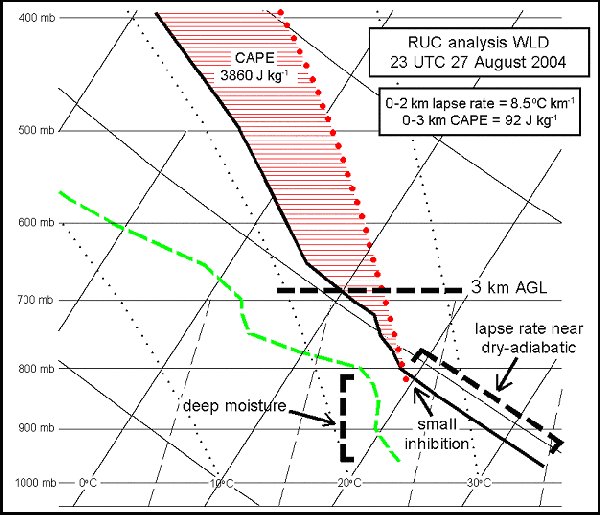 Figure 1 http://members.cox.net/jondavies2/nonmesotor_casestudies/nonmesotor_casestudies.htm 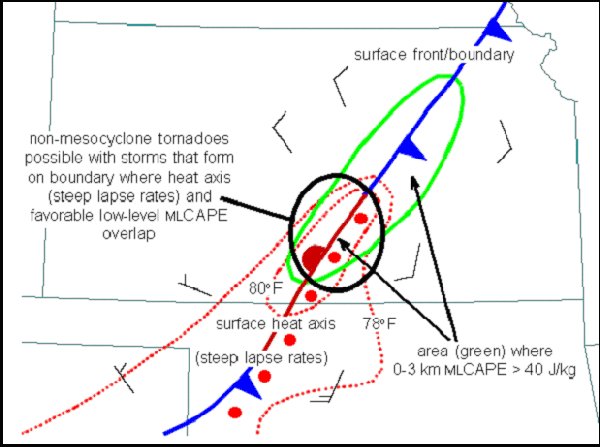 Figure 2 http://www.nwas.org/ej/cardav/figure1.html 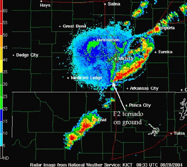 Figure 3 http://members.cox.net/jondavies2/nonmesotor_casestudies/nonmesotor_casestudies.htm 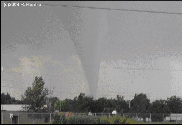 Figure 4 http://members.cox.net/jondavies2/nonmesotor_casestudies/082704wellingtontor1_rrenfro(c).jpg References: -NSSL 1: http://www.nssl.noaa.gov/users/brooks/public_html/tornado/#state -CRH 1: http://www.crh.noaa.gov/ict/newsletter/Fall2004.php#Section01 -Davies 1: Meteorologist Jon Davies Brief; Case Studies of Non mesocyclone Tornadoes in Small SRH and or High LCL Environments http://members.cox.net/jondavies2/nonmesotor_casestudies/nonmesotor_casestudies.htm -Davies 2: Tornados Associated with small SRH or High LCL Environments http://members.cox.net/jondavies2/4thSSSS.pdf -Caruso, Davies 1: Tornadoes in Non-mesocyclone Environments with Pre-existing Vertical Vorticity along Convergence Boundaries |