
The Santa Ana winds are a form of foehn wind, which occur when air is forced over a mountain range. As the air is pushed upslope, it expands and cools, causing water vapor to precipitate out. This dry air then passes over the summit and descends down the leeward side of the mountain range. As the air falls, it is condensed, which causes the air to warm adiabatically as the pressure increases around it. 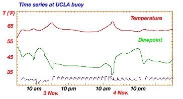 The Santa Ana winds are found in the Southwest California area, notably in the cities of Los Angeles and San Diego. Dominant high pressure over the high-altitude Great Basin leaks out of the basin and into the surrounding lowlands. The clockwise winds propel that air even faster over the southern Rockies and into the Los Angeles area. The hot, dry winds are typically 35 knots and have a humidity that can drop below 15%. Dewpoints can change drastically throughout the day with shifts in wind direction. This can be seen in the diagram above. Notably around noon there is a sharp drop in dewpoint followed by an increase. This fluctuation is directly linked to a shift in wind direction from the north/northwest to the west. These winds can be so intense and massive that they can blow dust and smoke from wildfires far out over the Pacific (as seen in photograph). 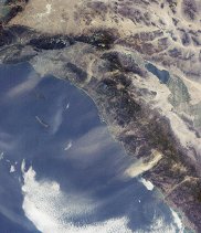 Contingent on the high pressure over the western US, the Santa Ana winds occur most often during the desert cool months of October through March. It is a common misconception that the winds are so warm because of the fact that they come from the hot desert. However, during these months, the desert southwest is actually cooler than Southwest California! The forecasting consequences of the Santa Ana winds are vast. Due to the proximity to the Pacific Ocean, the Southwest California region can experience drastically contrasted weather if these winds are forecasted incorrectly. This is due to the fundamental difference between the two possible air masses; the maritime Pacific air and the continental desert southwest air. Under normal circumstances, the westerlies will push the moist, cool maritime air from the Pacific Ocean over the area. Under Santa Ana circumstances, the area will be inundated with hot, dry air (as seen in picture). Because of this conundrum, proper forecasting is imperative. 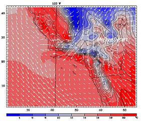 The two main forces that decide whether or not the Santa Ana winds will be felt in the Los Angeles Basin are the westerly winds and the high pressure over the desert southwest. If the westerlies are strong enough, they can prevent the east winds from crossing the peak of the Rockies and channeling down into the LA Basin. However, there are other factors to consider, for example, the temperature of the air blowing eastward from the Pacific. The colder this air, the more ōdammingö it will be to infiltration from less dense warm air blowing down from the Rockies. In the summertime, the high pressure over the Great Basin is not as intense, and the contrast of temperature from the maritime Pacific air is greater. This results in the infamous ōmarine layerö brought about by temperature inversion. In the autumn through early spring months, that high pressure system over the Great Basin can be much deeper, and the gap in temperature between the environmental air and maritime air blowing in from the Pacific is smaller. These seasonal variations are what enable the foehn winds to break the cap of the temperature inversion and plummet downward from the mighty Rockies and sprint through the Los Angeles Basin. The difference between whether the people of Southern California will feel the hot breeze of the Santa Ana winds or the cool, moist touch of the Pacific is so minute, that this phenomenon can be a daunting forecasting task. Even though the likelihood of Santa Ana winds is usually fairly straightforward on a day to day basis, there are isolated forecast periods where the probability of this event can be a forecasting nightmare. Santa Ana winds themselves can carry along with them many consequences. The airÆs intense lack of moisture and rapid speed can be nightmarish for wild fires. The danger of brush fires in Southern California is directly associated with the Santa Ana seasonality. The already dry climate of Los Angeles and Southwest California make for dangerous wild fire conditions. When you combine that danger with the bone dry, relentless winds of the Santa Ana, you have some of the most treacherous wild fire conditions in the world. 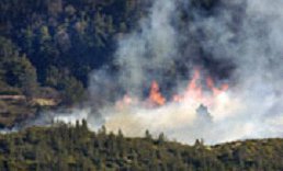 In the future, this forecasting difficulty could be improved upon with more extensive research into the relationship between the strength of high pressure of the Great Basin and the westerlies. More equipment in and around the region would also increase the amount of data received, which would help in future forecasting. Most importantly, the more accurate these forecasts can be, the better prepared firefighters can be to safely prepare and prevent wild fires. References University of California San Diego, ōClimate, Santa Ana Winds and Autumn Wildfires in Southern California.ö Eos, Vol. 85, No. 31, 3 August 2004. http://tenaya.ucsd.edu/~westerli/pdffiles/04EOS_Westerling.pdf University of California Los Angeles, ōThe Santa Ana Winds.ö Robert Fovall. November, 2002. http://www.atmos.ucla.edu/~fovell/ASother/mm5/SantaAna/winds.html Wikipedia, ōSanta Ana Wind.ö April 10, 2007. http://en.wikipedia.org/wiki/Santa_Ana_wind USA Today, ōSanta Ana winds raise SoCal fire fears.ö January 2006. http://www.usatoday.com/news/nation/2006-01-23-calif-fire_x.htm |