
Strong winds are nothing new or rare in a desert environment, where rapid heating and the mixing that accompanies them can boost breezes into the 15 to 20 mph range, especially during summer. But the Albuquerque metro area, because of its topography (i.e., especially the mountain ranges running to the east of the city) and location in New Mexico has a certain type of wind that has the capacity kick up wind speeds into the 30 mph range, with gusts up to 45 mph. They also have the capacity to foment precipitation and in many cases, limit visibility by stirring up dust. They’re commonly referred to in local meteorological circles as the East Canyon Winds or Canyon Winds for short. At times, they can perform like a katabatic winds, drying the topographically low Middle Rio Grande Valley that comprises part of the area, or in other instances even bring moisture to the area, or in many cases confuse the forecaster that hasn’t yet mastered the particulars of how they’re formed and when they appear. According to a National Weather Service report on East Canyon Winds from former lead forecaster Michael Ford, research from 1961 -1992 indicated that the strongest winds on average in the Albuquerque area came from the East or Southeast. They can appear in several ways. National Weather Service forecasters say East Canyon Winds most commonly appear as Gap Winds. That is, when the surface pressure builds to the east of the Sandia and Manzano Mountains that border the metro area’s east side and force air through the canyons. In particular, Tijeras Canyon, through which Interstate 40 and historic Route 66 pass through, is susceptible to being impacted by these winds. They most often appear in spring, summer or fall, when backdoor cold fronts make their way across eastern New Mexico. On surface progs, they commonly show up as a packing of isobars across eastern New Mexico (see attached graphic); although a packing of isotherms (thermal packing) or isohypses (thickness packing) can also be indicators of the potential for canyon winds. As they make their way down to the valley, they can lessen in intensity (Albuquerque’s West Mesa, which looms to the west over the Rio Grande Valley, often gets only a light breeze from Canyon Winds), but temperatures can sometimes increase on the order of several degrees Fahrenheit as the winds reach their lowest point and warm katabatically. They are not as frequent during winter months because the cold, polar air that tends to invade the lee side of the Rocky Mountains in New Mexico during the winter is often too shallow in depth to push its way over the mountains. Although surface pressure gradients may appear to be strong to the east of Albuquerque’s mountains, forecaster say such an air mass must attain a depth greater than 7200 feet for the winds to push through into Albuquerque, which at an elevation of 5,312 feet is America’s highest major city. 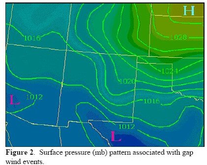 Another way East Canyon Winds can appear in Albuquerque is from outflow from thunderstorms in Eastern New Mexico. As these convective thunderstorms shed their rain-cooled air or collapse, one or several gust fronts can move toward and into the gaps in the Sandia and Manzano Mountains. The result is often sustained winds of 20 to 30 mph, with gusts of 40 mph +. While forecasters say the event only lasts a few hours (to as many as 12 hours), such winds often have other consequences. Since they are the product of convective storms, they carry high amounts of moisture, which if not mixed out by the next day, can cause anything from a few clouds to form to (with the proper heating) air mass thunderstorms by afternoon. If the Canyon Winds are strong enough, they can often push moisture-rich air all the way to the Continental Divide. Combined with heating or orographics, or in some cases dynamic lifting from other sources, they are capable of producing strong thunderstorms. As you might imagine, such a scenario is primarily limited to the summer months, though strong thunderstorms during spring and fall months have been known to produce such outflow/Canyon Winds. Forecasters have also identified a kind of East Canyon Wind event as the result of spill over winds, though they are not true gap winds in the sense that others mentioned are. These are winds that due to atmospheric circulation to the west and cold air pooling to the east, they often spill over the Sandia and Manzano Mountains. In many cases they can be stronger and more cover more of Albuquerque’s metro area than true gap winds. They most commonly form when a closed low in the upper atmosphere centers itself west of New Mexico anywhere from California and Arizona to just south of New Mexico’s boot heel. Meanwhile, strong high pressure in the Great Plains and to the east of Albuquerque’s bordering mountains creates a strong east to west gradient that can carry winds from the surface all the way up to the mid levels of the atmosphere (see attached). 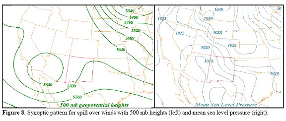 Forecasters in Albuquerque have documented 50 mph + gusts associated with such a scenario covering a span of up to 48 hours. According to former lead forecaster Michael Ford of Albuquerque’s National Weather Service office, such a setup can produce a major winter storm over the state and Albuquerque, though down sloping winds can often minimize the effects of the snow as they reach the Rio Grande valley and the city’s downtown area. In rare instances, such spill over winds can also produce turbulent, mountain waves coming off the Sandia and Manzano Mountains; downdrafts with a hit or miss nature which can kick up winds in excess of 40 mph and cause damage throughout parts of the city. How then, in the short term, can you nowcast for such events, other than looking at the synoptic scenarios presented in the progs? A formula attributed to former New Mexico television meteorologist Bill Isenhood handles this situation very well. It takes the hourly surface pressure reading at Albuquerque in millibars and doubles it (just the last three numbers, so that out of a reading of 1008.5, only the 08.5 would be doubled). Then, the hourly surface pressure readings in millibars from Amarillo and Colorado Springs are added together (again, just the last three figures, including the decimal). The Albuquerque total is then subtracted from the combined Amarillo/Colorado Springs total. If the result is a negative number, then there is no possibility of East Canyon Winds. But, if the result is a positive number, there is a definite eastward pressure gradient into Albuquerque. However, the figure needs to reach a threshold of 10 before it can truly be called an East Canyon Wind (figure 1 mph for every 1 millibar of pressure). The result is an almost-foolproof way of forecasting in the short term for East Canyon Winds. References Ford, Michael J., Lead Forecaster/National Weather Service, Albuquerque, NM; East Wind Storms at Albuquereque, New Mexico |