
In central to southern coastal California rainfall can be a rare event. The rainfall we do receive mainly falls from November to March, just about 80 percent of annual rainfall. Normal rainfall amounts are as follows: San Francisco- 21.5 inches Monterey Bay- 20.35 inches San Luis Obispo County- 24.26 inches Los Angeles County- 15.14 inches We owe our climate to a semi-high pressure area located over the eastern Pacific Ocean, which deflects storms northwestward, along with the precipitation. During the winter months, this high breaks down allowing the jet stream to steer mid-latitude weather systems along with the track of the prevailing westerly's. During the winter months, the rains can be very heavy. The weather pattern most likely to trigger heavy rainfall events is the "Pineapple Express". In winter, a high-pressure system over the Gulf of Alaska blocks the polar jet stream, which may split and form a southerly branch across the mid-Pacific. This polar high may weaken and shift westward, forcing this southern branch even further south to form a subtropical jet. As it flows around the blocking high, the subtropical jet heads northeastward, across or near the Hawaiian Islands. On its track through the tropics, the air mass warms and gathers moisture. Once formed, the Pineapple Express may persist for several days to more than a week, delivering copious, intense rainfall. These rainfall events are associated with the Madden-Julian Oscillation (MJO). The MJO is an equatorial traveling pattern of anomalous rainfall. This is shown by large regions of both enhanced and suppressed rainfall cycles. Each cycle lasts approximately 30-60 days. The MJO is most active during neutral-El Nino years and La Nino winters. La Nina is part of the El Nino Southern Oscillation (ENSO), a coupled ocean atmospheric phenomenon. La Nina, "Little Girl" is characterized by unusually cold sea surface temperature is the equatorial Pacific. 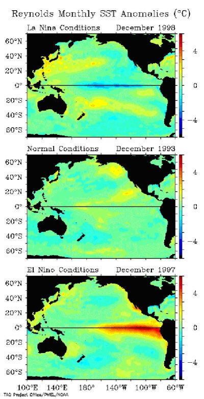 The typical weather pattern of the Pineapple Express is as follows: 1- 7-10 days prior- Heavy tropical rainfall associated with the MJO shifts eastward from the eastern Indian Ocean to the western tropical Pacific. A moisture plume extends northeastward from the western tropical Pacific towards the Hawaiian Islands. A strong blocking high is located in the Gulf of Alaska with a strong polar jet stream around its northern flank. 2- 3-5 days prior- Heavy tropical rainfall shifts eastward of the dateline and diminishes. The associated moisture plume extends further northeastward through the Hawaiian Islands. The strong blocking high weakens and shifts westward. A split in the Polar jet stream develops with an increase of the westerlies on its southern flank. The tropical and extra tropical circulation "phase" with each other, allowing a midlatitude trough to tap into the moisture plume extending from the tropics. 3- Precipitation event- As this pattern continues to shift further to the east this moisture feeds into the midlatitude trough located of the west coast of North America. Deep low pressure located near the Pacific Northwest coast can bring up to several days to a week of rain with possible flooding and landslides or debris flows. 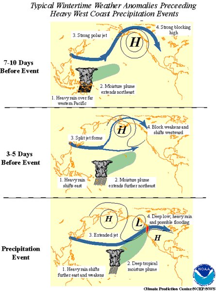 The combination of moisture laden air, atmospheric dynamics, and orographic lifting over the mountain ranges of the West Coast result in some of the most torrential rains to occur. These mountain ranges can reach elevations of up to 3,280 feet. As a storm system moves eastward, the air mass rises over the mountain, cools, and condenses outs on the windward side. One of the most recent events occurred from January 7 through January 11, of 2005. The San Gabriel Mountains of Los Angeles County was deluged with 31.61 inches in a five day period. Some locations on south and southwest facing mountain slopes in Santa Barbara County received up to 26 inches of precipitation. Satellite-derived data from polar-orbiting and geostationary satellites are used to indicate regions of strong tropical convective activity, and regions in which the convective activity departs substantially for the long-term mean. This is one of the best tools in order to directly monitor and predict the MJO as it propagates around the tropics towards the West Coast. 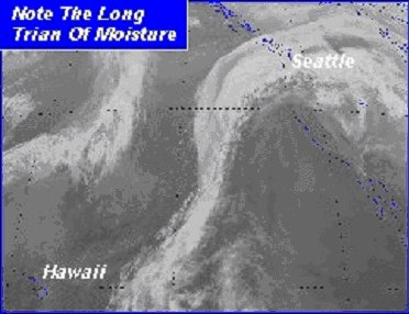 Lending a hand to California's landslide climate, is the seasonal variation in the rate of evapotranspiration, which is the loss of moisture by direct evaporation from the soil surface plus what is transpired by vegetation. Although this drying reflects a complex interaction of disparate processes, it is most strongly influenced by air temperature and solar radiation, which both reach a maximum in summer and a minimum in winter. The soil moisture stored in a hillslope reflects the balance between input of water from precipitation and loss of moisture from evapotranspiration. In California's Mediterranean climate, the precipitation and evapotranspiration cycles are about six months out of phase: Precipitation peaks in midwinter, whereas evapotranspiration reaches its maximum during the summer. The resulting phase shift yields a variation in soil moisture from fairly arid conditions in midautumn to near saturation in midwinter. This seasonal contrast profoundly affects the relationship between rainfall and slope instability in California. The antecedent rainfall or rainfall needed for debris flows to occur is a direct result of this type of climate. When the rainfall season begins in late October, hillslope soils are partially dehydrated by the long summer drought. Early seasonal rainfall is simply absorbed into the soil with little effect on slope stability. As the rainfall season progresses, soil moisture content increases until the summer deficit is erased. Subsequent heavy rainfall may saturate the void space in the soil, creating positive pressures that can destabilize the slope. With lack of rainfall in the spring and summer and warmer temperatures, along with longer daylight hours increase evapotranspiration, leading again to drier soils. All of these factors create the wacky weather bringing a year's worth of precipitation often resulting in catastrophic damage and loss of life. References: Wikipedia.Org http://www.wikipedia.org/wiki/Climatological NOAA Climate Prediction Center http://www.cpc.ncep.noaa.gov/products/intraseasonal/intraseasonal_faq.html National Weather Service/California Nevada River Forecast Center http://www.cnrfc.noaa.gov/dec2005storms.php National Weather Service Forecast Center/San Francisco/Monterey Bay http://www.wrh.noaa.gov/mtr/ |