
GRAPHICAL AREA DISPLAY:
LFC (LEVEL OF FREE CONVECTION)
| |||||||||||||||||||||||||||||||||||||||||||||||||||||||||||||||||||||||||||||||||||||||||||||||||||||||||||||||||||||||||||||||||||||||||||||||||||||||||||||||||||||||||||||||||||||||||||||||||||||||||||||||||||||||||||||||||||||||||||||||||||||||||||||||||||||||||||||||||||||||||||||||||||||||||||||||||||||||||||||||||||||||||||||||||||||||||||||||||||||||||||||||||||||||||||||||||||||||||||||||||||||||||||||||||||||||||||||||||||||||||||||||||||||||||||||||||||||||||||||||||||||||||||||||||||||||||||||||||||||||||||||||||||||||||||||||||||||||||||||||||||||||||||||||||||||||||||||||||||||||||||||||||||||||||||||||||||||||||||||||||||||||||
METEOROLOGIST JEFF HABY
The LFC (Level of Free Convection) is the height at which the region of instability begins when the CAPE profile is known. This marks the
elevation at which a parcel of air will rise on its own due to positive buoyancy. The Level of Free Convection value will depend on several
factors such as temperatures in the PBL, dewpoints in the PBL, and the temperature profile from the PBL to the middle levels of the
troposphere. Contributors to instability are high PBL temperature, high PBL dewpoint and relatively cool air in the
middle troposphere (i.e. 700 to 500 mb). When instability is present, the LFC marks the bottom of the region of instability. The
LFC value is given in meters and this value indicates how high above the ground the region of instability begins. A low LFC value
indicates the LFC is relatively close to the surface while a high LFC values indicates the LFC is relatively high above the surface. Values
less than 1,000 meters are relatively close to the ground surface while values above 2,000 meters are relatively high above
the ground surface.
The Level of Free Convection is looked at in the context of a thunderstorm situation. If there is no instability, then there will
be no LFC. Thus, surface based thunderstorms have to be possible before the LFC is relevant to study. If thunderstorms are expected, then
the next step is to determine if those storms could be severe and what severe characteristics they will have. LFC is looked at when making
a tornadic thunderstorm forecast. If no other limiting factors are present for tornadic thunderstorms, then a LFC relatively close to the
surface will increase the tornadic threat. This is because there is better overlap between instability and wind shear in the lower
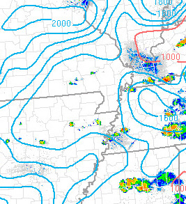
troposphere. The image below is an example of how contours of LFC will look on a map.
|
|
|