
METEOROLOGIST JEFF HABY
Florida is a peninsula, meaning it is surrounded on three sides by water. This makes for an interesting set-up since a sea breeze
can come from three different directions. A sea breeze is a flow from the sea toward the land that typically peaks in intensity
during the afternoon. It brings in a little cooler and moist air from the ocean. The sea breeze is created by a pressure differential
between the land and water caused by a varying vertical temperature structure over land as compared to sea. During the day, the
land warms more than the sea. This creates less dense air and a taller troposphere over land. This in turn creates a flow from
higher pressure toward lower pressure aloft. With this movement of air aloft away from land, the air closer to the surface has
to fill the air that is leaving and thus at the surface the wind flow is from sea toward land. A forecast implication is that
the sea breeze can act like a weak cool front that serves as a lifting mechanism. Since the air is typically warm and moist
over Florida, this lifting can aid in the development of storms.
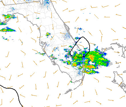
The image below shows an example of a weak sea breeze set-up that can aid in thunderstorm development. Since there are sea breezes
coming from three different directions, widespread low level convergence occurs. Notice many of the wind plots moving from the
sea toward the land. This air piles over the land and then rises with the sea breeze circulation. This helps initiate and/or
enhance the generation of storms that can be seen on the image.
|
|
|