
| WX MODEL 22: Sideways Trough
| |||||||||||||||||||||||||||||||||||||||||||||||||||||||||||||||||||||||||||||||||||||||||||||||||||||||||||||||||||||||||||||||||||||||||||||||||||||||||||||||||||||||||||||||||||||||||||||||||||||||||||||||||||||||||||||||||||||||||||||||||||||||||||||||||||||||||||||||||||||||||||||||||||||||||||||||||||||||||||||||||||||||||||||||||||||||||||||||||||||||||||||||||||||||||||||||||||||||||||||||||||||||||||||||||||||||||||||||||||||||||||||||||||||||||||||||||||||||||||||||||||||||||||||||||||||||||||||||||||||||||||||||||||||||||||||||||||||||||||||||||||||||||||||||||||||||||||||||||||||||||||||||||||||||||||||||||||||||||||||||||||||||||
METEOROLOGIST JEFF HABY
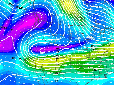
The trough in the 300-mb model image below has a unique orientation. Instead of having a trough axis that is more or less north-to-south,
the trough axis in this image is orientated east to west. A cut-off low has been in the southwest U.S. for several days. The jet stream
flow around the cut-off low produces this unique flow pattern. Cases where winds at the jet stream level are flowing opposite to normal
are called a retrograde flow. The central portions of the western U.S. in the image are experiencing the retrograde jet stream flow. The
winds are stronger in this case on the south side of the sideways trough. This is due to the stronger temperature gradient south of the
trough. The flow pattern is not conducive to moving the cut-off low out anytime soon. It will be stuck in the same region for several
more days. Not only is there a sideways trough, but to the north there is a sideways ridge. This is a reflection of the cold temperatures
across the continental U.S. with warmer temperatures over the Pacific Ocean. This is producing a unique jet stream over this region
that flows from north to south instead of the typical west to east. Air flowing into western Canada eventually ends up
in southern California! This type of blocking pattern is called a Rex Block.
|
|
|