
| WX MODEL 11: Wave on Cold Front
| |||||||||||||||||||||||||||||||||||||||||||||||||||||||||||||||||||||||||||||||||||||||||||||||||||||||||||||||||||||||||||||||||||||||||||||||||||||||||||||||||||||||||||||||||||||||||||||||||||||||||||||||||||||||||||||||||||||||||||||||||||||||||||||||||||||||||||||||||||||||||||||||||||||||||||||||||||||||||||||||||||||||||||||||||||||||||||||||||||||||||||||||||||||||||||||||||||||||||||||||||||||||||||||||||||||||||||||||||||||||||||||||||||||||||||||||||||||||||||||||||||||||||||||||||||||||||||||||||||||||||||||||||||||||||||||||||||||||||||||||||||||||||||||||||||||||||||||||||||||||||||||||||||||||||||||||||||||||||||||||||||||||||
METEOROLOGIST JEFF HABY
One place a low pressure system can develop and intensify is along an elongated cold front. When this occurs the low pressure will
initiate a cyclonic circulation on the frontal boundary. This will cause warm air to be drawn closer to the system on one side and
cold air to be pulled farther down on the other side. This has important forecasting implication since the strength and path
of the low will influence how much precipitation a location receives and the precipitation type(s) that a location receives.
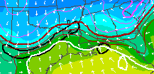
The model image below shows the reflection of a low pressure system developing along an elongated cold front boundary. This produces
a northern bulge along the cold front. This is a reflection of the warm air advection that is being drawn toward the low pressure
system on its right side (centered over Louisiana). Colder air is being drawn from the north on the left side and can be seen
by the colder air and cold front progressing to the south over Texas.
|
|
|