
This lesson covers the geostrophic wind, surface wind, gradient wind, sub and supergeostrophic winds and the cyclostrophic wind. THE GEOSTROPHIC WIND The geostrophic wind is the wind flow that occurs in the middle latitudes aloft in the troposphere. The winds have a more difficult time obtaining geostrophic balance in the equatorial latitudes since the Coriolis force is weak. The geostrophic balance also does not occur at and near the surface since the force of friction is significant there and the geostrophic balance does not occur in a curved flow since a centrifugal force is introduced in that situation. What the geostrophic wind includes is a balance between the PGF (Pressure Gradient Force) and the Coriolis force. This flow results in the wind staying parallel to height contours. The PGF is the force resulting in the pressure difference between higher and lower pressure. The PGF points directly from high to low pressure (or heights). The Coriolis force results from the spin of the Earth and is directed to the right of the path of motion in the Northern Hemisphere. The diagram below shows an example of geostrophic balance in the Northern Hemisphere. The wind flows with higher pressure (heights) to the right of the path of motion and lower pressure (heights) to the left of the path of motion. The PGF points from higher toward lower pressure (heights) and the Coriolis points to the right of the path of motion (which is equal in magnitude but in the opposite direction of the PGF in order to balance it). The height contour spacing determines the magnitude of the wind. Closer spacing results in stronger wind. 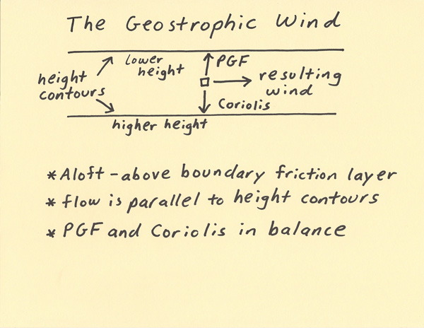 THE SURFACE WIND The surface wind is the balance of forces on the wind that occurs at and near the Earth’s surface. The contrast to the geostrophic wind is that the surface wind introduces the force of friction. In the diagram below labeled (1) we start with geostrophic balance and introduce friction. Friction is a force that slows the wind and this is why the friction vector is in the opposite direction to the resulting wind labeled on (2). When friction slows the wind it causes a reduction in the Coriolis force since the magnitude of the Coriolis force is directly related to the wind speed. Although the Coriolis force decreases, the Pressure Gradient Force (PGF) stays the same. This results in an imbalance between the Coriolis and Pressure Gradient Force. The PGF has a greater magnitude as compared to Coriolis. This results in the wind crossing the isobars at an angle from higher pressure toward lower pressure. In the diagram (2), it shows the balance of the forces between Coriolis, friction and PGF along with the resulting wind. The result is that at the surface, air flow convergences into low pressure systems and divergences from high pressure systems. 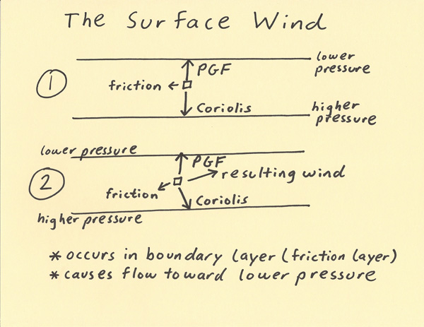 THE GRADIENT WIND The gradient wind is a balance of the Pressure Gradient Force, centrifugal and Coriolis. A geostrophic wind becomes a gradient wind when the wind begins flowing through curved height contours. The curving motion introduces a centrifugal (outward fleeing) force. The centrifugal effect can be felt when turning through a curve in a car. You stay with the car but it feels like you are being pushed sideways. The gradient wind occurs aloft (no friction) within curved height contours. The wind stays parallel to the height contours throughout the curve. The two examples below will be used to show how the flow stays parallel to the height contours. In the first diagram below (the trough), the outward fleeing centrifugal force is pointing in the same direction as the Coriolis (Northern Hemisphere, Coriolis is to right of path of motion). PGF must balance both centrifugal and Coriolis. For this to happen, the Coriolis needs to shorten so that Coriolis + centrifugal stays equal to the magnitude of the PGF. Since the Coriolis decreases, the wind speed decreases. This allows the wind to stay parallel to the height contours. Without this wind speed reduction the wind would follow a more straight line path that would cause it to move from lower toward higher height contours. Another way to think of this is that the PGF is greater in magnitude than the Coriolis thus the wind is going to bend more in the direction of PGF and this causes the flow to stay parallel to the height contours. In the second diagram below (the ridge), the outward fleeing centrifugal force is pointing in the same direction as the PGF (Northern Hemisphere, to left of path of motion). PGF and centrifugal must balance Coriolis (Northern Hemisphere, Coriolis is to right of path of motion). For this to happen, the Coriolis needs to get longer so that Coriolis = centrifugal + PGF. Since the Coriolis increases, the wind speed increases. This allows the wind to stay parallel to the height contours. Without this wind speed increase the wind would follow a more straight line path that would cause it to move from higher toward lower height contours. Another way to think of this is that the Coriolis is greater in magnitude than the PGF thus the wind is going to bend more in the direction of Coriolis and this causes the flow to stay parallel to the height contours. 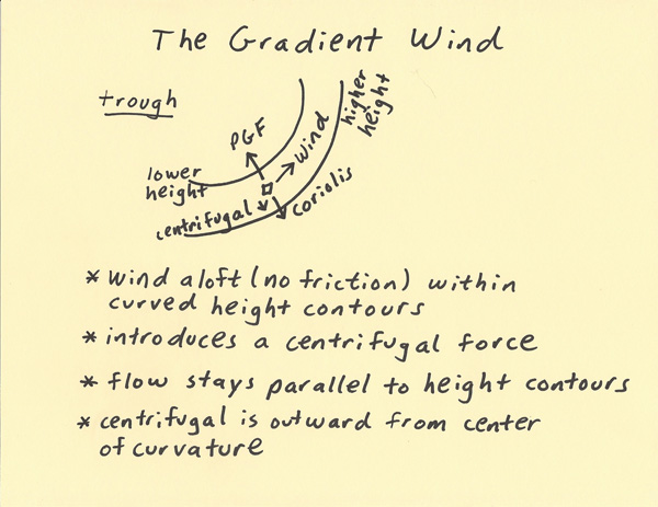 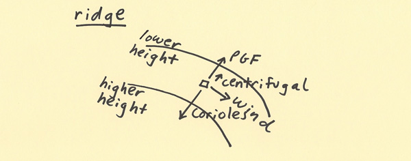 SUBGEOSTROPHIC AND SUPERGEOSTROPHIC WIND The information in this lesson is an extension of the previous lesson on the “Gradient Wind”. A gradient flow through a trough is termed “subgeostrophic”. The “sub” means the wind speed is less than what would be expected if the wind was geostrophic. In the first example below (“subgeostrophic wind”), the wind is flowing through a trough. In this diagram below (the trough), the outward fleeing centrifugal force is pointing in the same direction as the Coriolis (Northern Hemisphere, Coriolis is to right of path of motion). PGF must balance both centrifugal and Coriolis. For this to happen, the Coriolis needs to shorten so that Coriolis + centrifugal stays equal to the magnitude of the PGF. Since the Coriolis decreases, the wind speed decreases. This allows the wind to stay parallel to the height contours. Without this wind speed reduction the wind would follow a more straight line path that would cause it to move from lower toward higher height contours. Another way to think of this is that the PGF is greater in magnitude than the Coriolis thus the wind is going to bend more in the direction of PGF and this causes the flow to stay parallel to the height contours. A gradient flow through a ridge is termed “supergeostrophic”. The “super” means the wind speed is greater than what would be expected if the wind was geostrophic. In the second diagram below (“supergeostrophic flow”), the outward fleeing centrifugal force is pointing in the same direction as the PGF (Northern Hemisphere, to left of path of motion). In this example the wind is flowing through a ridge. PGF and centrifugal must balance Coriolis (Northern Hemisphere, Coriolis is to right of path of motion). For this to happen, the Coriolis needs to get longer so that Coriolis = centrifugal + PGF. Since the Coriolis increases, the wind speed increases. This allows the wind to stay parallel to the height contours. Without this wind speed increase the wind would follow a more straight line path that would cause it to move from higher toward lower height contours. Another way to think of this is that the Coriolis is greater in magnitude than the PGF thus the wind is going to bend more in the direction of Coriolis and this causes the flow to stay parallel to the height contours. The point of this discussion is that the wind flows slower through troughs and faster through ridges when height contour spacing is the same for each. In reality, the height contour spacing is typically much closer together in a trough. Thus, in reality, wind speed is stronger in troughs since the Pressure Gradient Force is typically much higher in troughs. 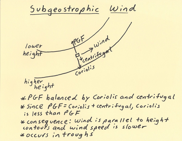 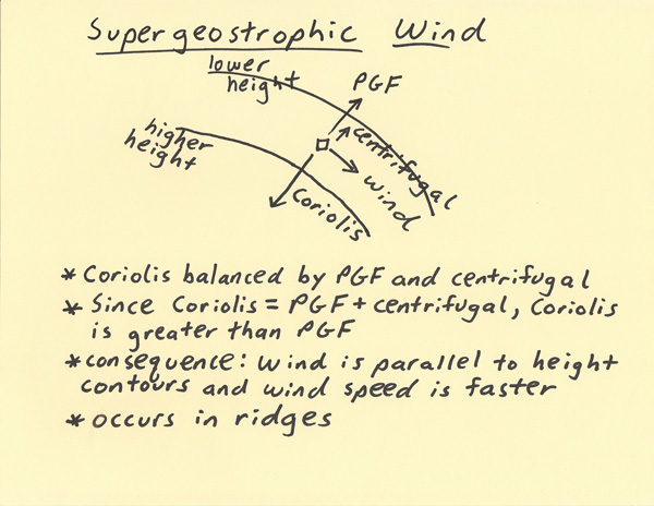 THE CYCLOSTROPHIC WIND The cyclostrophic wind differs from the gradient wind in that the Coriolis force is not involved. The Coriolis force requires long time periods (hours) in order to become firmly established. Rotations that occur in the time scale of minutes or less will not be significantly influenced by Coriolis. The cyclostrophic wind is a balance between the Pressure Gradient Force (PGF) and the outward fleeing centrifugal force. A cyclostrophic wind also tends to have a “tight” curvature compared to curvatures within troughs and ridges. This occurs since the wind motion is not only over short time scales but also over much shorter distance scales. Examples of cyclostrophic weather events include circulations within thunderstorms, tornadoes and wind eddies. A cyclostrophic circulation can result in a brief but rapid drop in surface pressure due to the rising motions these circulations can produce. 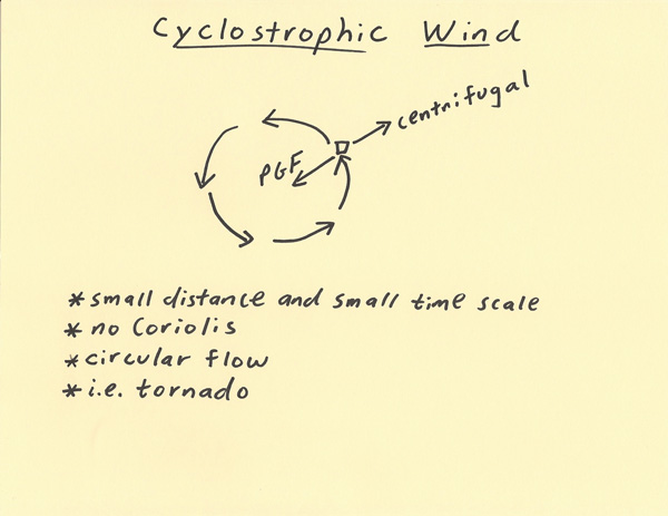 |