
| PRECIPITATION UNDER THE RADAR
| |||||||||||||||||||||||||||||||||||||||||||||||||||||||||||||||||||||||||||||||||||||||||||||||||||||||||||||||||||||||||||||||||||||||||||||||||||||||||||||||||||||||||||||||||||||||||||||||||||||||||||||||||||||||||||||||||||||||||||||||||||||||||||||||||||||||||||||||||||||||||||||||||||||||||||||||||||||||||||||||||||||||||||||||||||||||||||||||||||||||||||||||||||||||||||||||||||||||||||||||||||||||||||||||||||||||||||||||||||||||||||||||||||||||||||||||||||||||||||||||||||||||||||||||||||||||||||||||||||||||||||||||||||||||||||||||||||||||||||||||||||||||||||||||||||||||||||||||||||||||||||||||||||||||||||||||||||||||||||||||||||||||||
METEOROLOGIST JEFF HABY
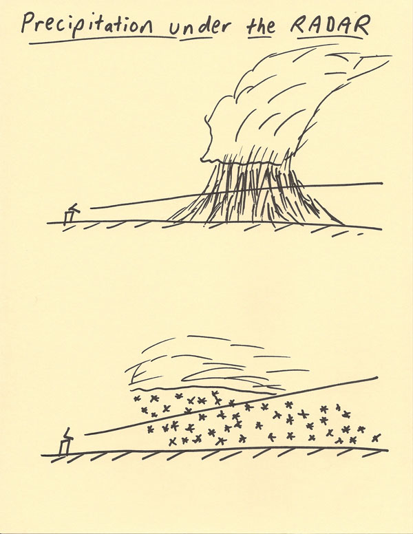
The diagram below shows a pedagogical model of the lowest beam angle available to a particular radar. Due to several factors, the beam typically
climbs progressively higher into the atmosphere as the beam moves away from the radar. This occurs due to Earth’s curvature, the beam starting
with an angle higher up than the horizon to reduce the chance of the beam hitting Earth’s surface, and cases where refraction causes the beam
to bend more upwards. The consequence of this is that the radar will not be able to detect precipitation under the lowest beam angle. What
appears on radar can be experienced differently for a surface observer. One factor that causes this is wind. Wind can move precipitation
a significant horizontal distance as it is falling. A no precipitation area on radar can experience precipitation observed on the ground
due to the wind. The opposite is true also. Precipitation shown on the radar for a particular location may not reach the ground at that
location due to wind. It is cases of convective storms and snowfalls that this effect can be most noticeable. Other examples of factors
that can cause the precipitation observed on radar to be different from what is observed at the surface include: precipitation
evaporating before reaching the ground (virga), the radar map not perfectly contouring to Earth’s curved surface, strong refraction
of the radar beam, convective air currents, and ground clutter. In the diagram below, a visual representation is shown for how the
precipitation detected aloft will undergo the process of moving to another location by the time it reaches the ground.
|
|
|