
The jet stream is one of the most interesting features that a weather forecaster analyzes when forecasting for the mid-latitudes. It develops on a global scale while also having a significant influence at the local scale. The polar jet stream is a ribbon of high velocity upper level wind (i.e. generally found between the 500 and 150 millibars levels). The polar jet stream influences the weather in the polar and mid-latitudes but typically does not influence the tropical latitudes as much. The strong winds of the jet stream are generally strongest when polar/arctic air is adjacent to mid-latitudinal/tropical air. This contrast in air mass sets up an enormous pressure gradient force that causes strong wind speeds (over 100 miles per hour). When analyzing the jet stream, it will be noticed that it looks like a wave pattern. Where the wave is displaced to the south (trough) then cold air will advance into lower latitudes. Where the wave is displaced to the north (ridge) then warm air will advance into higher latitudes. Thus, the polar jet stream has a huge impact on weather. This is especially true in the late fall, winter and spring when cold air is adjacent to warm air. 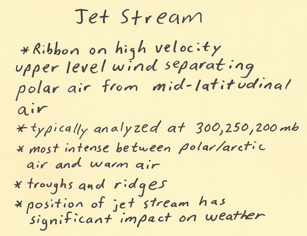 The diagram below depicts the polar jet stream flowing between the polar and mid-latitudinal regions of the Northern Hemisphere. To the north of the jet stream is cold air while to the south of the jet stream the air is warm. The air flow is counterclockwise around the Earth when viewed above the North Pole. 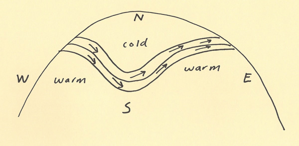 This paragraph will explain how the winds of the jet stream are created. Cold air is denser than warm air. Thus, the depth of the troposphere is less in cold air and the pressure levels are closer together in the vertical. Warm air is less dense than cold air. Thus, the depth of the troposphere is greater in warm air and the pressure levels are spaced farther apart in the vertical. When cold air is next to warm air, a huge pressure gradient will develop. In the diagram below, if you follow the dashed line from one side to the other then the warm column will have a higher pressure than the cold column will have at that same elevation. The flow will be from higher pressure (warmer air) toward lower pressure (colder air). It is also important to point out that the difference in pressure is more significant with height. At the surface, the cold and warm air will have about the same pressure. However, in the vertical the pressure difference between the cold air and warm air becomes magnified. Thus, this is why the winds of the polar jet stream are strongest in the upper troposphere (i.e. 300 millibar level). To complete the understanding of the polar jet stream winds, the next paragraph will discuss the influence of the Coriolis effect. 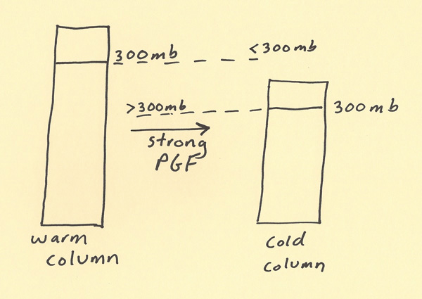 Since the Earth rotates, air that is closer to the equator will move a longer circular distance than air closer to the pole. This is like a spinning CD. When the CD goes around one time, the outer edge of the CD will have to travel a greater circular distance compared to a place closer to the center of the CD. The air on Earth stays in place since the air is moving basically with the Earth as it rotates. The air does not stay in place though when the air has to move to a different latitude (since there is a different circular distance to cover as latitude changes). In the diagram below, the warm air to the south will initially move toward the cold air to the north. The Coriolis effect will then turn this wind to the right of the path of motion. Thus, a basically south to north flow will become basically a west to east flow. As air moves toward the north, it is moving from a region where the circular distance to go around the Earth is a longer distance and is moving into a region where the circular distance to go around the Earth is a shorter distance. Thus, the air moves ahead of where it would go compared to if the Earth did not rotate. The polar jet stream is created from warm air to the south moving toward cold air to the north and then the Coriolis deflecting the wind flow toward the east. The winds of the jet stream will vary in exact magnitude and exact direction depending on the positions of the warm and cold air masses and how close these air masses are together. 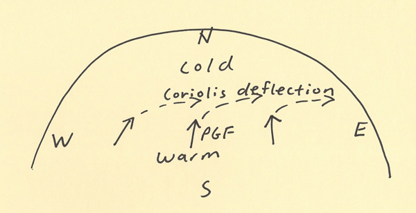 |