
When it comes to satellite meteorology it is all about the clouds. Imagine just a few decades back and all the time before that we had no way of seeing the earth from space. What an amazing perspective it is to be able to see the earth from space, where the storm systems are and how they are moving. We can see exactly where hurricanes are in the open ocean, the entire cloud structure of mid-latitude traveling cyclones and all the interesting characteristics of clouds. Can you imagine not having satellite data today? The satellite is by far the most important tool for monitoring hurricanes over the open ocean. Loss of life has decreased dramatically since weather satellites have been used. Can you imagine how much worse the hurricanes over the last several decades would have been to loss of life if no one knew they were even coming. It is bad enough when we know they are coming. But knowing it is coming or at least the potential of it coming gives some time to prepare. The cost of weather satellites is all worth it just on hurricane monitoring alone. 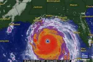 Satellites make seeing the big pictures of synoptic meteorology clear. We can see entire pressure systems and the cloud formations. We can see how they move. The developed low pressure systems have a comma shape with cloud bands often extending along the frontal boundaries and around the center of low pressure. With data more lacking over the open ocean, satellite data is used to monitor low pressure systems as they approach the coast (such as the example below with the low moving into California). On satellite we can see the influences from topography and clues to where the air masses are moving. What is so great about satellite data also is that it is pure data of what we are seeing in the atmosphere. It is not a model nor a chart nor a depiction. It is the real raw deal!... just like looking outside to see what weather is going on. 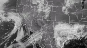 Satellites can see all the interesting cloud characteristics. In operational use this happens to a great extent in severe weather monitoring. The explosive updraft, overshooting top, anvil and storm pattern can be seen on satellite. This data along with radar gives us the first indication of where storms are actually firing up and where they are moving. Boundaries that are the focus of thunderstorm develop can often be seen clearly on satellite especially as the storms start firing off. These boundaries may be outflow boundaries, topographic boundaries, fronts, a dryline, a sea breeze or some other sort of boundary. With high resolution the entire severe storm structure can be examined along the boundary of the clouds. Satellites also supplement synoptic data. They can estimate moisture, temperature, wind speed, and instability over cloud free areas. |